

| Oliver's Cornwall |
|
in the country |
|
|
|
|
|
Most I like but a few reviews are distinctly critical. |
Text and images should align. To view this page at its best, adjust your zoom to fill page width
CORNWALL REVIEWS INDEX and SITE CONTENTS
|
|
|
|
|
|
|
|
|
|
|
|
|
|
|
|
|
|
|
 |
Altarnun is an attractive
village, along with Blisland the most interesting
on this part of Bodmin Moor. Aalong the main street there is a straggle
of houses, stone or slate built, some slate-hung, one or two of them substantial
Georgian homes. At the lower end of the street is the church, dedicated
to the mother of St. David, St. Nonna, said to have founded this church
in 547AD. Her Holy Well is just off the road that heads north.
Known as ‘The Cathedral of the Moor’, the church is approached by a narrow
and ancient packhorse bridge over the fast-flowing little Penpont Water.
Outside, unexpectedly exotic trees thrive in its churchyard and a Cornish
cross stands at the top of a bank. A little way up the hill in the
village is a former Wesleyan chapel, over its door a stone likeness of
John Wesley, a regular visitor, carved by local man Nevil Northey Burnard.
Wesley stayed often in the nearby village of Trewint in Digory
Isbell's home, now a museum to Wesley and Methodism. Altarnun,
surprisingly, has three shops but no pub or teashop. Perhaps it doesn't
really welcome visitors, although I felt welcome enough when enquiring
about a trail leaflet for the Inny
Valleys Walk, which I did in July 2006 - there wasn't one, nor
a sign from the village which, for a walk shown as a trail on the Ordnance
Survey map, really quite shocked me. St. Nonna's Church & Holy Well |
|
|
Signed (1 mile) off A30 7 miles
west of Launceston. |
| Inny Valleys Walk: Full detailed directions, and a 2 mile extension by way of Polyphant, see my Bodmin Moor Walks page |
 |
There is a lot that is both unusual and admirable about Blisland, one of Bodmin Moor's, and indeed Cornwall's, most charming villages. To take the unusual first, you don't find many proper village greens in Cornwall - but you do find one in Blisland. Roughly triangular, the church is on one side, the Blisland Inn on another, the Manor house is on the base. The church has an odd dedication, to Sts. Protus (or Pratt) and Hyacinth, and an interior like a pre-Reformation church. The Blisland Inn has a reputation for its real ales and the atmosphere of a real welcoming local pub. The Manor house has the four-square appearance of a Georgian home with a two storey Elizabethan style porch - and, most unexpectedly, on its north face two Norman windows and a Norman arch. Now for the admirable. It looked at one time as if Blisland was going the way of so many villages, dormitories with no heart, soul or amenities. But Blisland fought back and now it has not only its pub but a school and, since 2006, a community centre in the real sense of that phrase. A great effort replaced the lost village shop with a brand new convenience store, whose groceries include local produce, plus cafe, doctor's surgery and internet café. Pub, church, school and store make Blisland a real village. |
|
|
Leave the A30 shortly before Bodmin |
 |
Passing through now, on the road to Wadebridge, Bodmin appears at first glance to be a rather scruffy, inconsequential town. But first appearances can deceive. Heading west into Bodmin, as you drop down into the town, look to your right and you will see Cornwall's finest and most important parish church, dedicated to St. Petroc, who founded a monastery here around AD550. Turn left by it and you will find yourself in Mount Folly Square, filled with handsome Victorian buildings: The Shire Hall housed the county's Assize Courts until 1988, the Public Rooms were once the social heart of the town. Continue past these, along the Lostwithiel Road, and you will discover former county regiment barracks and a railway station that served a line to Wadebridge, opened in 1834. Or follow the road to Wadebridge and you will see signs for Bodmin Jail and pass Westheath Park, now an upmarket housing development and technology park but once site of the county lunatic asylum. Put all these together and you will realise that this was once once a place of great significance, the County Town from 1836 to 1988. There are several things for the visitor to see and do, though little advertised. The Shire Hall houses the TIC, exhibitons and a Court Room Museum. Bodmin Jail is now a museum with restaurant. The Town Museum is in the Public Rooms. Do not miss St.Petroc's Church. Bodmin & Wenford Railway operates steam trains on the old Wadebridge line. |
|
|
Bodmin is signed from the A30 in both directions |
| Bodwen scarcely qualifies as a Town or Village; in reality it is no more than a hamlet. You could easily miss most of Bodwen, whose name means the old dwelling. Part of it, the part of greater interest, is down an unsigned dead-end turning. Here is a small farm, a couple of converted barns and some renovated cottages. I would guess that Bodwen is a dormitory village for Bodmin. There are some cottages on the road through to Luxulyan and, at a cross roads south-east of the village, a former chapel now serves as a cold store for a food producer across the lane. |
 |
 |
|
|
|
| When I started this web site I didn't like Boscastle very much. I was about ready to post a critical item when the dreadful flood of August 2004 happened. That was no time for criticism so I decided to leave it until repair and restoration were complete. I am glad I did because, before and after a walk up the Valency Valley in June 2008, I took time to explore the village. Now not only am I most impressed by the way Boscastle has recovered but I also find that I now like it. It may be very tourist oriented - Visitor Centre, National Trust shop, Witchcraft Museum, art and craft galleries, gift shops, restaurants, cafés - but it looks terrific. Scenically it is hard to beat thanks to its setting in a steep valley, the River Valency winding down to a small harbour (dry at low tide) with a few fishing boats, beyond it two high headlands, both on the coast path, and the sea. In the photo a lime kiln stands in front of the former 'pilchard palace'; the latter now houses the TIC, a National Trust shop and café and a Witchcraft Museum. And don't miss walking up Old Road, a narrow no-entry street, to admire its charming cottages. I can't comment on eating places as I have only had coffee here, but for sociability the Wellington Hotel bar is probably top; other pubs are the Cobweb and the Napoleon at the top of the village. | 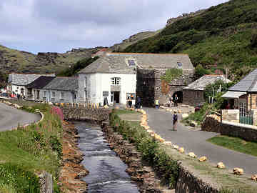 |
| Coastal Round Walk from Boscastle includes St. Juliot church. |
|
| On the last Saturday in October 2016 I headed towards the River Tamar and Cornwall's boundary with Devon. I was fortunate with a warm sunny day but disappointed when I found the first object of my expedition, St. Stephen's Church in Launceston, firmly closed. What is it about town churches that mitigates against their opening; I have had the same problem elsewhere, most notably in Lostwithiel. I continued to Yealmbridge for a photo of the attractive bridge. Built around 1350, it is considered the oldest surviving and best built of medieval Cornish bridges. Nikolaus Pevsner described it as Cornwall's "most ambitious" bridge. A pity he felt unable to visit and comment on my next port of call, Werrington Church which, most disappointingly was, like St. Stephen's, firmly locked with no indication of where a key might be found. I say disappointingly because it is suggested that the church may be one of William Kent's last works; indeed, the exterior with its pair of low towers and its statuary suggests that could well be the case. Happily, when I continued to Boyton, although the church was locked, I found the key with a helpful nearby resident. Inside both nave ansd aisle have barrel vaulted ceilings with carved roof bosses. Only a little remains of the original screen and both pulpit and chancel pews have unexpected froated glass panels. A plain circular font is probably of Polyphant stone. In the village attractive homes include the former forge and the old Post Office. Follow the road downhill, cross a recent bridge over the infant River Tamar into Devon and you come to beautifully set Boyton Mill, now an attractive home but still with mill and waterwheel intact. |
 |
 |
|
|
|
 |
Some would spell it Bradock, some Braddock; I prefer Bradoc. Whichever way you prefer it the name is English rather than Cornish and is simply a corruption of Broad Oak. It is a very strange little place. Miles from habitation of any size, 1½ miles from the nearest road (as opposed to lane), and consisting only of three proper buildings: the church, the Old Rectory and the rectory's former Coach House. It's farm, the organic Penventon, is the best part of a mile away by lane and track; further along the track is Killboy Cross. St. Mary's church consists of nave, south aisle, north transept and tower. It is attractive and has a pretty little north lych gate. When I went to see the church in January 2016 it was locked and I was unable to see the inside but got some good photos in good light. I was later able to see inside the church - see item immediately below. The building is a mix of Norman to 16th century, with original wagon roofs, a Norman font, Elizabethan pulpit and remains of a rood screen. A number of carved bench ends have been joined as a panel on the front pew. There are some unusual panels in what remains of the rood screen (the rest is in Boconnoc church), one of a woman holding a snake's tail. West, in Boconnoc Park, is the site of a civil war battle of 9 January 1643 when Hopton's Royalist forces defeated a Parliamentary army. |
|
|
Signed from A390, Lostwithiel - Liskeard, at West Taphouse |
| I returned to Bradoc in late February 2016, thanks to Churchwarden Carol Spear who very kindly met me at the church with the key. Before meeting Carol at the church I had taken the opportunity granted by a sunny morning to seek out Killboy Cornish Cross (at grid ref: 16482/62281). This is accessed by a grassy track from Polventon Farm on the Fortescue's Boconnoc estate. The cross, set into a circular base, though not long restored, is badly degraded, lichen covered and difficult to photograph, thanks to its proximity to a hedge. |
| I visited Breage, on the Marazion and Penzance road beyond Helston, in mid-May 2017. My purpose was to add to my collection of Cornish Crosses by finding the one in Breage. As it turned out, the first one I found wasn't in Breage at all but on the Helston to Marazion road, on the corner of a lane heading for Trevena, opposite the car park of a garden centre. Having photographed the cross, I continued on to Breage village where there was indeed a Cornish Cross in the churchyard, near the porch. The church its, as so often in Cornwall, stands on a high mound, suggesting an older pre-Christian site. On Shute Hill, leading up to the church, there are attractive cottages; beyond the church is the Queens Arms Inn. The church itself consists of nave, two aisles and a three-stage tower. The lych gate opposite the pub lacks roof and coffin rest but does have a coffen stile. Inside, the nave is impressive and the chancel is approached beneath an elaborate rood screen, complete with rood, beyond it an elaborate reredos. On north and south walls is a fine collection of frescoes, wall-paintings, unusual for Cornwall, and an inscribed "Roman" stone stands in a corner of the south aisle. A carved stone, possibly part of a headstone, with a Christ figure, flanked by two others, stands beneath a window. |  |
| Breage is off A394 Helston to Penzance road |
Breage Church |
Bude - a once run-down town which gets steadily better and better
 |
Our original
2003 report - but please read also the 2009 update box below
Like Portreath and Hayle, Bude is a run-down town for which we have great affection. When the railway arrived in 1898 Bude developed as as resort, with hotels and villas with sea views. After World War II, and the later loss of its railway in 1966, it went downhill and now has no quality hotel but caters rather to the lower end of the bus tour trade. However, Bude has many saving graces, not the least its superb Summerleaze Beach, where the tide recedes a full quarter mile. A sea lock there is the start of the Bude Canal (2 miles restored) that once carried sand inland. Behind the beach look out for the Bude Light, which remembers Sir Goldsworthy Gurney who lived in the castle, built a steam road vehicle in 1829, and devised a complex system of arc lights and mirrors which lighted Parliament for 60 years before electricity. Above the beach, to the south side, the Pepper Pot stands high on Efford Down, its sides marked with the points of the compass, some 7 degrees out of true; good views. Little good eating, except at the bar of the Falcon Hotel by the canal. An easy round walk takes in Bude, Widemouth Bay and the Canal. It follows the coast from the Pepper Pot to Widemouth Bay, crosses fields to the excellent Weir café/bistro at Helebridge, then follows the canal back into Bude |
|
|
Signed from A39 'Atlantic Highway' |
| BUDE UPDATE JULY
2009 When my sister May stayed with us in July 2009 we
spent a day in Bude, a place we always enjoy. In the morning we walked
the beaches, then lunched at the Castle. In the afternoon we walked
the canal and had tea at Woodlands Tea Rooms at Helebridge (2013, now
superceded by The Weir). We found that, even since our last visit,
Bude had improved. The storm damaged canal sea lock has been restored
and more work done on the canal. The Quay is smarter, the Castle
is now Heritage Centre, gallery, museum and restaurant.
Hotels: 2013 - improving. Hebasca is a boutique hotel in the modern style. The Beach describes itself as 'Luxury Hotel' and looks good. Bude Castle: We were delighted to find that the town has now taken full advantage of the possibilities of the Castle. Exhibitions on Bude as port, resort and surf centre; Sir Goldsworthy Gurney exhibition; research centre; art gallery; shop; Café Limelight. Helpful staff. Wheelchair access. The Quay: New paving makes it feel more spacious and there is now a row of craft and similar shops. Castle Restaurant: We lunched there and recommended it strongly. Apparently re-opened as Café Limelight 2014. Olive Tree cafe: We first tried it in 2019 and like it very much. Good food, good coffee, good value. Bude Canal: Now fully restored for its 2 miles to Helebridge, including the two locks along the way. Wouldn't it be wonderful if restoration could take place on the Marhamchurch incline plane and all the way to Tamar Lakes. The Visitor Centre in the car park now has a Canal Heritage Centre. One (walkers) criticism - The tarmac towpath, while wheelchair-friendly, now makes the walk to Helebridge feel noticeably less rural. Walks: Coastal Round Walk from Bude. Inland Walk Helebridge, Bude and Canal. More walks on the Bude Canal. |
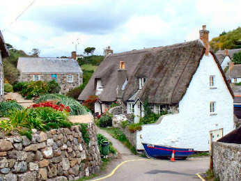
| One of the most popular
villages on the Lizard peninsula - along with Coverack,
which I don't much like, and Mullion, which I do (my favourite is St.
Keverne) - pretty Cadgwith is tucked away on the east coast between
Lizard Town and Coverack. There are two roads down to the village
and cove; the car park is on the western of the two and may
appear to be a long way from the cove but there is a fairly short footpath
down. Once at the cove there are several pretty thatched and whitewashed
cottages; one stands on the Todden, a small point overlooking the
harbour. Old net lofts and pilchard cellars are now shops, a tea
shop and a restaurant. The Cadgwith Cove Inn has folk music on Tuesday
night, traditional Cornish singing on Friday. Cadgwith has the largest
fishing fleet on the Lizard, inshore boats no longer after the pilchards
but now seeking crab, lobster, mullet, mackerel, sea bass and occasionally
shark. They are quite a sight drawn up on the beach. If you
haven't seen The Fisherman's Apprentice, do watch for it, set in
Cadgwith. A mile north on the coast path is Carleon Cove where part
of the old serpentine works still stands. A few hundred yards south
is the Devil's Frying Pan, a massive blow hole formed when a large cave
collapsed. Try to catch the sea at the right state of the tide to
appreciate the impressive effect.
A coastal round walk includes Cadgwith. |
|
| Signed from B3293 Helston to St. Keverne road |
|
 |
During a walk in November 2007 from Zelah to Chiverton Cross, as part of the Land's End Trail, I passed through a lot of places with the Callestick (or Callestock) name. Originally they would all have been the Callestoc recorded in Domesday Book. I counted Little Callestock, Callestick, Old Callestick Mine and Callestock Veor (Great) plus Callestick Vean (Little) which wasn't on my route. The present village of Callestick, the largest of the settlements, was presumably originally Callestock Veor. It is an attractive place in more senses than one. A handsome Georgian farmhouse, beautifully presented cottages, a former Methodist chapel converted to a home, a well kept Methodist graveyard, a small maker of quality ice cream and the Cornish Cyder Farm. I stopped at the latter for a coffee and cake when on the Land's End Trail in 2007. In September 2008 I was again walking the Land's End Trail - this time west to east - with my friend and neighbour Richard. It was a warm day and, feeling in need of refreshment, we stopped at Callestick Farm for a first-class ice cream. They also do bacon baps and cream teas. They are open all year (though in winter just Wed to Sat). I used to recommend Callestick Farm - until Jane and I were short-changed on a cream tea. |
|
|
Signed from A30, 5 miles west of Carland Cross |
| I was in Callington on a mid October 2016 day when I also looked at Merrymeet, St. Ive Churchtown, West Harrowbarrow and Dupath Holy Well. It is a very ordinary small town with a populatrion of around 5,000. I had hoped to see inside St. Mary's Church, fairly impressive from the outside, but it was locked so I had to content myself with views of a much-weathered lantern cross and the adjacent clink, once the town lock-up, now home to a small business. Opposite the church a lane leads to the Pannier Market. In Well Street s the old Pipe Well, once the town's water supply. The town holds a Honey Fair on the first Wednesday of October; it is a major street fair but I haven't been able to discover its origins. The two most noticeable features of Callington are the occasional view north to Kit Hill and a series of murals, three of which are seen below. The town hall has a mural trail leaflet. |
 |
 |
 |
|
|
|
|
 |
I
revisited Calstock in early February 2018, after seeing St. Dominica's
Church. I had hoped to look inside St.
Andrew's Church, half a mile up the hill from Calstock itself; sadly, like too many Cornish churches, it was
locked. So I headed down the hill to the
village. I note from the Church of
England's web site that the church should be open each day between 12 and
2. I was there at 1.30 so I have emailed
the incumbent to ask for more information on opening days and hours. Anyway, I enjoyed my visit to Calstock
village, where the sun was shining and the Tamar sparkling. Last time I was in Calstock was with Jane,
when we walked along the river from Cotehele and enjoyed a pleasant light lunch
sitting in the sun on the terrace of the Tamar Inn. At one time Calstock was a very prosperous
port, serving local tin and copper mines. Now it is a quiet spot most of
the time, its former wealth shown only by some big three storey homes and a
main street that was once clearly full of shops and inns. Near the water,
the Tamar Inn, quite ordinary when we first encountered it, has much improved
with good food and a pleasant outside seating area. An annual regatta
remembers the days of the pilot boats that guided the ships into the
wharves. Probably best to avoid Calstock at holiday times and summer
weekends; it then turns into a bustling resort. |
|
|
Signed from A390, just west of Gunnislake |
| Last time I was in Camborne town, as opposed to the many locations round and about such as Heartlands and Carn Brea, was when Jane and I attended Trevithick Day there in April 2006. This time, in November 2016, I was there to pursue my imterest in the works of the Thrussells. Unlike all their other work that I have seen, this was indoors: a thorn tree in the middle of the raised area in the vast Wetherspoons, the John Francis Basset (mining magnate). This building was once the New Market House, later housing St. George's Hall and the Scala Cinema. Round the corner is St. Meriadoc's church, where there was a Christmas Tree Festival in progress, dozens of decorated trees spread around the nave and aisles. My main interest here was the churchyard where there are two fine, and very different, Cornish Crosses. Until the 19th century Camborne was a tiny hamlet but the tin and copper boom of that century saw rapid growth. The last mine closed in 1991 although it is hoped (2016) to re-open Wheal Crofty soon. Good public buildings include the Josiah Thomas Memorial Building and the Centenary Wesleyan Church. Outside the Passmore Edwards Library, at the foot of Basset Street, stands a statue of Camborne's most famous son, Richard Trevithick. His childhood home in Penponds, open on occasion in summer, is now in the care of the National Trust. |
 |
| More images of Camborne |
|
 |
 |
 |
| Camborne Vestry or Clink |
Camborne Centenary Wesleyan Chapel |
Dolcoath Wheal Harriett Wheel |
 |
I had been through Carharrack on several previous occasions when researching the Redruth and Chacewater Mining Trail, though the very first time was on a walk from Lanner Hill to Bissoe, led by Mark Kaczmareck and Kingsley Rickard. That was one of the relatively few guided walks we have ever joined but one which we were glad to be part of because it gave us our first proper, and most informative, introduction to Cornish Mining and the Mining Trails. On this occasion, in early November 2016, I was pursuing my interest in the marvellous metalwork of father and son team Gary and Thomas Thrussell which brought me to Carharrack Park Playground. What I came to see in the archway in the photo on the left. But I was amazed and delighted to find there was much more in the playground: Mosaic work, butterflies and bees in the path, giant wooden mayfly and spider and other work worthy in its way of the Thrussells. In an odd way my favourite piece was a waste bin in the form of a blue dotted yellow mushroom. There were also stacked wooden cubes carved with entertaining speed statistics. Although I was disappointed that the church was locked, my visit to Carharrack was rounded off by spotting a modern Cornish Cross on the road junction opposite. From Carharrack I continued to St. Day, Gwennap and Gwennap Pit. |
|
|
On B3298, about 4 miles south of A30 at Scorrier |
| I deal with Charlestown in some detail on my Museums page, under maritime museums, largely because of the Shipwreck and Heritage Centre there. But it is certainly worth an entry in its own right and another photo. Originally known as West Polmear, you might normally expect that the name of Charlestown would have been acquired in the 17th century and would reflect a connection with King Charles I or II. But the man it is named for is Charles Rashleigh, landowner with interests in mines, china clay and railways. Employing engineer John Smeaton, during the early 19th century he transformed a small fishing harbour into what you now see. The surprise is that Charlestown has retained its Georgian flavour so strongly, despite the presence of 21st century tourism. There are a couple of pubs; the Rashleigh Arms, on Fore Street above the harbour, is preferred, particularly since its make-over. There are several restaurants and cafês, most open all day and serving good local produce. Charlestown is a lovely place to visit but it can get very busy, so you would do best to avoid the height of the holiday season. The village is signed from the halfway along the A390 St. Austell by-pass, a busy and often congested road; given the choice and a nice day I would always prefer to approach it along the coast path. |  |
| Signed from A390 St. Austell bypass |
|
 |
Once part of the Stowe estate of the Grenvilles, the hamlet of Coombe is now owned by the Landmark Trust, which specialises in restoring interesting buildings of historic and architectural importance and letting them as up-market holiday rentals. The surrounding land is part of the National Trust’s Stowe Barton estate. The hamlet consists of a tall watermill, once known as Stowe Mill, the mill house, two semi-detatched cottages and a couple of converted barns. All, apart from the mill, are rentable. The mill is intact, including all its machinery and a large waterwheel, but large a colony of bats prevents its conversion at present. However, the Landmark Trust hopes to use the mill to provide Coombe’s electricity. The hamlet is divided by a small river with a shallow paved ford and a footbridge. Cottages are thatched and whitewashed, all are quite charming and easy to photograph. One pair of cottages is known as Hawker’s Cottages. For a while Rev. Stephen Hawker, rector of Morwenstow, lived in the left-hand one. Coombe is just half-a-mile from the coast at Duckpool but, if on foot, the most enjoyable way to approach is from Stowe Barton, on a path through broadleaf woodland. You can do this as part of a round walk from Northcott Mouth. |
|
|
Near the coast, on the way to Steeple Point |
| When I posted this
report, back in October 2005, I never expected the furious response I received
from lovers of Coverack. So, in December 2010, I am updating my report.
Personally, and that's what this site is all about, I still don't much
like the village. The feeling I get from many visits is of drabness
but clearly I am in a minority so I shall now try to be fairer. Many
families holiday here year after year and love it. The beach can
be more rock than sand, even at low tide, but that varies from year to
year. I have often noticed wind-surfers here, the sheltered bay makes
a good spot for that. There are several attractive thatched cottages
on and off the main street. Views are a bit restricted but are best
from Dolour Point. Coverack's one serious claim to fame was its lifeboats
which, over the centuries, saved countless lives, many from ships wrecked
on the dreaded Manacles reef. In 1898 the SS Mohegan was wrecked
there with the loss of 106 lives. The following year American liner
SS
Paris went aground on Dolour Point but no lives were lost. The
village's pleasant pub, the Paris Hotel, commerorates the occasion.
Sadly, there is no longer a lifeboat in Coverack and the former lifeboat
station is now a restaurant (good reputation for its fish). Harbour
Lights café is open all year. Below is an email from my first
critic, her view supported in 2010 by Matt Tonkins of St. Keverne.
|
 |
| Another
view of Coverack entirely - Coverack Revisited 2017 |
|
Another View of Coverack - From Tess Warburton
 |
Hi Oliver, I
was just reading your rather critical review of Coverack. I holiday
in Coverack every year, along with many other families who return there
each summer to enjoy beautiful surroundings and friendly inhabitants.
I have been going to the village for almost twenty years and although I
have travelled to many places in the south west it is still my favourite.
In many ways I am pleased you don't like it. If you had stayed long
enough in the village and been bothered to find out what it is really like
you would have written a more far more colourful description. This would
however have encouraged lots of other people to holiday there, including
people like yourself (who think it is possible to understand and make judgments
about a place within a paragraph). I wish you luck with your touring.
However, maybe you should 'stay put' in some of the places you visit before
you judge them and influence the decisions of others.
ps. There are two beaches in Coverack, the beach in the village and the headland beach (named by local people as 'Mears' beach). The sand washes from one beach to the other anually so that one year it will be on Mears and the next it will be in the harbour. |
|
|
Thanks for your input Tess. Clearly families love Coverack. |
My original report on Coverack was way back in 2005. I was there again a couple of times in 2010, researching a pair of Coastal Round Walks, one by Proustock and St. Keverne, the other by Porthkerris, Porthallow and St. Keverne. On Tuesday 8th July 2017 there was heavy overnight rainfall followed by disastrous flooding which was reported even on national television. It may not have been as bad as the notorious Boscastle flood of 2004 but a great deal of damage was done. The large car park and the road into the village were torn up but Cornwall Council and their engineering agency Cormac pulled out all the stops and within a very few days access was fully open again. We felt we should show solidarity so on 1st August we made the almost 2 hour trip (the return took much less time) to Coverack to see how it was faring. The (honesrty box) car park was fully open and you would never guess that the road had been torn torn up only three weeks before. The sun was shining as we walked down into the village and everywhere was looking lovely, far better than my memory of the place. On the way we stopped at Elizabeth's (below left). I had a well filled bacon bap, Jane crab sandwiches - excellent. When I had been in Coverack previously, each time the weather had been dull. and photographs had disapppointed; this time the day was ideal and I got some really good images.
 |  |
| Elizabeth's Tea Cottage | Boats in Coverack Harbour |
| Jane
and I were in Truro in Mid-October 2017 and, having finished our business
early, decided to follow up a news item we had heard on local radio recently
and visit the village of Crantock, just to the south-west of Newquay. The news item concerned St. Carantoc's Holy
Well and we were able to park close by. The
well is right in the centre of the village, in a small enclosure alongside
attractive Well Cottage. The well itself
has a small wooden door; sad that there
was no water. We then walked round to
the church, standing in a large graveyard;
an abundance of crosses but no old Cornish Crosses. St. Carantoc's is an odd looking church,
seemingly added to randomly over the centuries.
After such a lowly exterior, the rich interior is a great surprise. As you enter, you face a carved St.
Christopher. To your left is a Norman
font, heads at each corner. To your
right, the rood screen immediately stands out, richly carved. with its rood
intact and a curve of painted ceiling above. Sadly, there are no original bench ends, though a gilded one
is displayed in the chancel. The minister's
stall and choir stalls are attractive. Just
a short distance away by a road past the church is Crantock Beach, a vast
stretch of pristine sand between Pentire Points East and West, where the Gannel
River joins the sea. From May to
September a ferry crosses from the Fern Pit cafe on the Newquay side. At low neap tide you can walk along the shore
of the river to a wooden footbridge to the Newquay side. More images of Crantock |
 |
 |
| St. Carantoc's HolyWell |
Crantock Beach |
|
While
so many Cornish villages sadly have little or nothing left of the facilities
that villages once had, Crantock retains many of the features that make a
village - church, village stores and post office, tea garden and art and craft
gallery, and two pubs, the Old Albion and the Cornishman. Oddly church (described and pictured on my Holy
Sites page), and pubs are away from the circle that appears to be the
village centre; fortunately a sign points down a tiny lane
towards them. The circle in question is
a small garden, enclosed by hedges.
Equally oddly, for such a small village, there are two pubs, the Old
Albion and the Cornishman. When I
visited the village and church in November 2018, I enjoyed lunch at the Old
Albion. From the village a lane leads
out to West Pentire headland, another down to quiet, sandy Crantock Beach at
the mouth of the Gannel estuary, a lovely spot with a handy large National
Trust car park. |
 |
 |
| Lychgate Cottage and the Old Albion Inn |
The Old Albion Inn |
| Jane and I visited Creed for an NGS open garden day way back in August 2006. Spotting that the garden opens in mid-June this year, 2016, we decided to make another visit. But first, I decided I would return to re-visit the church and to look around the nearby village of Grampound. I had a fine sunny day for it and was able to get some good photos. Oddly, while you might reasonably expect that tiny Creed, a mile south of Grampound, would be no more than an adjunct to it, it is Creed which is the original settlement, with the major church, while Grampound's church is no more then a Chapel of Ease. There is very little to Creed, just the handsome airy church, the big house, Creed House, and its lodge east of the church, Creed Farm, one of it's barns converted to a dwelling, and a small but handsome old barn with tallet steps abutting the churchyard. Creed House has a pleasant garden with fine specimen trees. I had always known that my father's cousin Bertie had, as Rev. A. E. Coulbeck, been rector of St. Just in Roseland. In 2006 it came as a surprise to me that he had previously been rector here and that Creed House had been his rectory. Notable figures connected with Creed were William Gregory, discoverer of titanium, and Parliamentarian John Hampden who represented Creed and Grampound in the time of Cromwell. |  |
| In Grampound, on A390, a small sign points south to Creed |
|
 |
In mid-May 2017 I visited Crowan and Clowance. I had only been here previously when walking the Land's End Trail in 2009 and had not then lingered in either place. This time I was in search of Cornish Crosses. First I visited Crowan Church where I found a cross head on a plinth near the porch. Inside the church the rood stairs are still in place but, of course no rood loft. There is some colourful stained glass and an elaborate St. Aubyn memorial. Down the road towards Clowance is a former mill, still with its water-wheel in place. Then I parked in the car park near Clowance House and spent a couple of hours walking the estate, primarily in search of more Cornish Crosses. There are three stone crosses, one near the Golf View Apartments, one behind cabin number 17 and a third, sadly invisible, on an island in the lake. By the path, to the north-west of the lake, a sign explains the Cornish Crosses and has a few words about Cornish saints, too. I walked around the lake and took photos of its little boathouse. There is an entertaining feature in the grounds to the west of the house: a Greek temple, one side of it a chess board, the other draughts. |
| A barn at Crowan Glebe Farm | Signed from A39 Truro to Falmouth road |
Return to Towns and Villages
 |
A charming village, tucked quietly away from the busy Truro to Falmouth road, Devoran's present belies its past. Now a quiet and beautiful creek-side village, boasting a fair number of small-boat sailors, Devoran was once a busy commercial port, shipping copper ore from mines on the Great Flat Lode around Redruth, linked by the horse drawn Redruth and Chacewater Railway, now part of a Coast to Coast trail. When you see how the creek has silted up - ironically with mine spoil - it is hard to imagine how any cargo boats ever got as far as Devoran - let alone Bissoe further upstream. The old village is a triangle of streets, Quay Street and the higher St. John's Terrace linked by Market Street. Along Quay Street several homes are interesting conversions of old warehouses or of former port worker's cottages. On the Quay, a series of odd stone enclosures are the old ore hutches where the copper ore awaited shipment. West down Restronguett Creek there are some mining related remains and at low tide you can see an odd causeway of stepping stones. The Old Quay Inn has an enjoyable local atmosphere; food is fairly ambitious gastro-pub. We have eaten there on several occasions and have always liked it. If there is no space in the pub's car park, you should be able to park by the village hall at the start of Quay Street. A round walk from Devoran |
|
|
Signed from A39 Truro to Falmouth road. |
| Unusually, this entry appears on three different pages: here under towns and villages but also on my antiquities page and my churches and holy places page. The reason is that, for such a small village, there is so much variety of interest. The form of the church, while not unique to Cornwall, is most unusual. It consists of nave, north aisle, south transept and a strange leaning tower attached to the south transept. The tower was once taller but the top stage was replaced by a pyramidal roof in the 19th century. It leans northwards at a sharper angle than the Leaning Tower of Pisa; fortunately the rest of the church holds it up. Inside, behind an elaborate parclose screen, possibly made from the former rood screen, the chancel aisle was built as the Colshull family chapel and contains Sir John Colshull's tomb, his recumbent effigy on it, and several elaborate slate memorials. The rood loft may be gone but the stair and loft doors remain. About 600 yards south of the church, alongside the road to Looe, is St. Cuby's Holy Well. What is claimed to be his original font was moved from the well site and now stands in the church. A few yards north of the church a sign directs you to Duloe Stone Circle, a small circle of 8 stones, believed by some once to have enclosed a cairn. A storyboard, somewhat weathered, stands by the hedge behind the circle. |  |
| Duloe is on B3254, about 4 miles south of A38 at Liskeard |
|
 |
There are really several distinct Falmouths. Approaching from the north, first the boatyards and marinas of Penryn, once a separate fishing village. Next Dunstanville Terrace, its grand sea captains' homes looking across the water to Flushing. Next the much improved cobbled High Street leads to the diminished interest of Market Street and up-and-coming Church Street, its shops improving. Then opposite the Tudor manor of the Killigrews is a vast timber shed, looking to Flushing and across Carrick Roads to St. Mawes; this is the superb Maritime Museum, beyond it the dockyard. Next is fortified Falmouth, Pendennis Castle high on its headland. Finally, the sandy beaches of resort Falmouth, lined with hotels and apartments. A good Art Gallery is near High Street in the centre of town. What surprises about Falmouth is that, despite the world's third largest natural harbour and its ideal situation for international shipping, there was no such place until the 17th century. There were just three small settlements - with Penryn to the north, the Killigrew manor of Arwennack below Pendennis Head, and Henry VIII's Pendennis Castle. But when Falmouth grew it grew fast and by 1688 was the main Packet Ship port. The port declined with the advent of steam but from 1863 the railway brought tourists. Now cruise ships take advantage of the deep water to anchor here. |
|
|
Ferries operate to St. Mawes, Flushing, Trelissick and Truro |
| When I started this entry I couldn't claim to have explored Feock properly, having just stopped off briefly on my way to Trelissick for a Fal Creek walk. However, I returned in late September 2016 for a more thorough exploration. The village proper is inland; to its south is Loe Beach with seasonal parking, a slipway and a seasonal beach café. To the west, with a small car park above, is Pill Point, about the only public access to the expensive looking Pill Creek. Above Feock church, said to have been founded by St. Feoca, are its detached bell tower, some attractive white painted cottages and a book exchange in the old phone box. Beyond the church is the Old Vicarage, now a private home. There are upper and lower lych gates - the lower has a room above it - a massive yew by the east end and a fine Cornish Cross by the porch. Inside the church are hatchments of local notable families, a 12th century font of blue Cataclews stone, a wall banner of a 1576 map of Cornwall, a low marble (or alabaster) chancel screen, a carved wooden pulpit, a colourful chancel ceiling and an elaborat reredos. A charming village (there is actually much more of it, very expensive looking) with an equally charming church and churchyard, well worth a visit. Leaving Feock, I took a wrong turn looking for Kea and spotted an old toll house just off the Playing Place roundabouts. |  |
| From A39 S
of Truro, L at Playing
Place More Feock Images |
|
 |
 |
 |
| Pill Creek |
The Book Exchange |
Loe Beach |
| Originally called Nankersey, the village acquired its present name when Dutch engineers were employed to build the village’s quays. They were from Vlissingen, known to the British as Flushing. Oddly there is another Flushing on Gillan Creek south of Falmouth; no connection is known. This Flushing is an attractive village with some big houses on St. Peter’s Hill and Trefusis Street, many once the homes of Falmouth ship’s captains, now probably homes of commuters to Falmouth or Truro. One such, Rockside on Trefusis Street, looks like a handsome Georgian house but, according to Pevsner, it is a converted warehouse. Flushing is very much a small boat sailing village and an important annual regatta week is held in summer, complete with swimming and bath-tub racing as well as sailing. According to Wikipedia Henry VIII had planned to build a castle on Trefusis Point to complement those at St. Mawes and Pendennis in guarding Falmouth but never did. Flushing is no longer the fishing village it once was but there are still a few commercial boats. And, sadly, many of the houses are now, like so many in Cornwall’s more attractive villages, used as second homes. Happily there are still two pubs, the Royal Standard and the Seven Stars, and there is a nicely located restaurant on The Quay, the Waterside with tables outside. The Trefusis Estate, in which you walk much of the way to Mylor Churchtown, is part of Devon-based Clinton Estates; the Trefusis family holds the title Baron Clinton. St. Peter's Church |  |
| From Penryn, on old A39 follow signs for Flushing |
|
| Click here for a circular walk from Mylor Harbour, taking in Flushing. |
 |
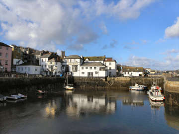
An attractive small town with very narrow streets and a one-way system. However, its quaint and scenic attractions are less easy to enjoy than those of St. Ives and St. Mawes, comparably pretty waterside towns. While they both cluster around a harbour and have walkable waterfronts, Fowey has no harbour as such but depends on its deep tidal river. And while St. Ives and St. Mawes face the water, Fowey's buildings back on to the river and almost nowhere can you walk by the water. There are attractive shops in Fore, North and Lostwithiel Streets and pretty alleyways climb the steep hill. Of the several pubs, the King of Prussia is best known and there are now some boutique hotels. The town has a long maritime history. In medieval times it provided ships for the Crusades and for the wars with the French. Henry VIII considered it of sufficient importance to fortify it with a pair of castles and a chain across the River Fowey. Now there are yachts, fishing boats and a china clay terminal up-river and, thanks to the deep water of the Fowey River, cruise ships visit occasionally. A major regatta takes place in August. Don't expect to park in the centre, instead follow car park signs on the periphery and be prepared to walk. A round walk - Lantic Bay and Polruan |
|
|
Signed from A390 from just west of Lostwithiel. More Fowey |
| There are also many literary associations. Kenneth Graham is said to have gained inspiration for 'Wind in the Willows' here whilst guest of Sir Arthur Quiller-Couch. Daphne du Maurier stayed at Ferryside House in Bodinnick and lived at three rented homes (one was Menabilly, her 'Manderley'). A Du Maurier Festival is held in May |
| Although I have been in Fowey many times since the above report, in April 2016 I decided it was time to revisit with a view to producing a further report. Here it is. I parked at Caffa Mill, where the Bodinnick ferry leaves from, much eassier to use than Fowey's other car parks. I was amused by the promotional hoardings for a new apartment development now being constructed on the north side of the car park. It promotes itself as having "beautiful estuary views". I hope someone like the Advertising Standards Authority will take Acorn Blue Developments to task over that: At that point the Fowey is river not estuary and, except from the upper floors, the view will be of the car park. I enjoyed wandering along Passage, North and Fore Streets to reach the heart of town. I admired the old buildings including Scallop Shell House (the former Post Office), the Well House, Noah's Ark, the Town Hall, the King of Prussia pub and the Ship Inn. I spent some time in St. Nicholas church (also dedicated to St. Fimbarrus) and admired the screen, the pulpit, the font, some fine bench ends, John Rashleigh's tomb and other Rashleigh memorials. Outside, high on the wall to the left of the porch, I spotted the head of, I think, a bearded fisherman. I ate my sandwiches on Town Quay, watching the activity on the water, then enjoyed coffee in the Galleon. |  |
| Back to main Fowey entry |
|
| I first encountered Golant many years ago, at a time when Jane and I were first looking for a home in Cornwall, she as a returnee, I as an incomer. Then we stayed at the Cormorant Hotel, in a room overlooking the Fowey River. And not just the river: A railway passed in front of the hotel as well, carrying china clay to the deep-water terminal on the river just north of the Fowey to Bodinnick ferry. I next encountered Golant when walking the Saints Way, a thirty mile walking route from Padstow on the north coast to Fowey on the south. Golant is a slightly odd place, its church way out of the village, almost half-a-mile north up a steep hill. Golant itself is a sailing place with two pools separated from the river by the railway line; to get to the river proper boats have to pass under the railway. The Fishermans Arms is a pleasant pub, with views over the river, where I have enjoyed lunch when walking the Saints Way. Their online menu looks attractive, comprehensive and reasonably priced featuring, at lunchtime, Cornish pasties, burgers, sandwiches, panini and ploughmans. There is a Kayak hire business, a cafe and two art galleries, not bad for a village with a population of little more than 200. |
 |
 |
| Golant's upper harbour |
Golant's lower harbour |
Return
to Towns and Villages
Return
to Home Page for Cornwall Reviews Contents
| I would never have thought of visiting Golden, were it not that, when operating my touring business for visiting Americans, I drove Kenneth and Anne Golden from San Diego, California. His Morley ancestors were from Minstead in the New Forest and I took them there. By remarkable coincidence, not far from MInstead was a Golden Farm but there was no connection. Kenneth believed that his Golden ancestors were from Cornwall but had no idea where. This tiny hamlet must have been his ancestors' Cornish home. Golden is an odd and unexpected little place. A sign on the road from Grampound Road to Tregony points to Golden Mill. On the way down the hill, first comes Golden, consisting of Golden Manor Farm, its farmyard and a massive former chapel, now used as a barn. At the bottom of the hill, just before you come to the little River Fal, is Golden Mill itself with a range of buildings, including Manor Farm Cottage and some handsome barns. One barn, with the "Vicar and Spaniel" sign in the photo below, may have been the miller's house and is now where the hunt takes its refreshments. This is all part of the Galsworthy's Trewithen Estate and is a centre for the Trewithen Hunt. There is a large car park used by the hunt on shoot days, when the game is pheasant - and all sorts of wildfowl, as well as woodcock and partridge. |
 |
 |
 |
|
|
|
|
| On my way to Golden,
I looked at Cornelly where the church might be of interest.
It was locked! But open at a later date! |
Gorran Haven and Gorran Churchtown
 |
Jane and I had been
here in 2002 on a round walk from Porthluney Cove. Then we thought
little of Gorran. I repeated the walk in March 2008 and lingered
long enough to revise my impressions somewhat. Gorran Haven is attractive
with nice old fishing related buildings clustered around the harbour.
Facing south-east, the harbour dries out at low tide and provides a safe
bathing beach with a seasonal café. Some narrow old streets
climb the hill from the harbour and there is a lot of recent development
beyond. Undoubtedly many of the houses are second homes and holiday
rentals. On the way up the hill is the little St. Justus Church,
a chapel of ease once used as a fish cellar and net store. Further
up, the former Llawnroc Inn is now the boutiquey Lawnwroc Hotel.
Keep going for another mile and you come to Gorran Churchtown. Here
is the Barley Sheaf Inn (restored and re-opened 2012 by a descendant of
the 1837 founder) and the handsome St. Goran's Church. St. Goran
(or Goranus) is probably the Guron of Bodmin, who moved here when St. Petroc
arrived there. His 13th to 15th century church is typically Cornish
with its crenellated and pinnacled porch, a fine collection of original
bench ends and some good modern wood carvings. Outside there is an
unexpected vault dated WSG 1813 and, when I was there, a lovely display
of daffodils. Short round walk from Porthluney. Short round walk incl. Gorran Haven. |
|
|
From A390
at St. Austell, take B3273 through Mevagissey |
| In early June 2016
I visited Creed Church, where my father's cousin Bertie - the Rev. Albert
Edward Coulbeck - was rector for three years from 1947 before he moved
to St. Just in Roseland. Creed
is down a narrow country lane, a mile south of Grampound, so after looking
around the church, I carried on to Grampound and parked by the Village
Hall. I walked up one side of the long hill that is Grampound's Fore
Street and back down the other, stopping for an excellent light lunch and
coffee in the St. Austell Brewery's Dolphin Inn. A pleasant pub,
with car park behind, with something of a gastro-menu but enough ordinary
fare to appeal to me. I enjoyed an excellent, reasonably priced bacon
butty. The name of the village is thought to derive from the Norman
French Grand Pont,
the great bridge over the little River Fal at
the bottom end of the village. Grampound appears larger than its
population of around 700 would suggest but, then, it is not much more
than
a one street village, climbing a moderate hill up from the river.
For a village which lines a busy main road - the A390 from Truro to St.
Austell - it is surprisingly attractive, filled with what appear to be
18th century houses and cottages but are probabaly, like the thatched
Manor
House, far older. But it can't be a lot of fun living on such a
busy
road.
Grampound Revisited |
 |
| Car parking by village hall, village shop and café |
|
|
I
was back in Grampound at the very end of September 2018, puspose to take a look
at the former Grampound Mill. I parked
in the public car park at the bottom of the village, crossed the road and
headed up Mill Lane, an attractive residential street, parallel to, but
unfortunately out of sight of, the little River Fal. At the end of the lane. after just under half-a-mile,
the lane comes to a dead end at the former Town Mills. Unfortunately there is no access, the site being
very securely gated so, for a description, I rely on its British Listed Buildings
description. The mill is mid-19th
century with later additions. It appears
to be largely intact with several ancillary buildings in its compound. What you see in front of you, as you look
through the gate, is the original building, with its hoist dormer still in
place. Apparently the overshot waterwheel
is still in place at the far end of the building but it is not visible. As a listed building, one of great importance
to the village, it is a great shame that nothing appears to have been done to
restore it, perhaps as a visitor attraction.
|
 |
 |
| Abandoned Cottage near Grampound Mill |
Grampound Mill - also abandoned |
 |
On New Year's Eve 2016 I headed down west to visit All Saints Church in Marazion to see an exhibition of works by a local artist - no sign of it. I didn't think much of the church either though I was impressed by a large collection of embroidered kneelers. I walked around Marazion and was tickled to see that three successive photos were all of buildings or shops with colours in their names - In the Pink, Out of the Blue and Silvermine! From there I went on to Gulval, an attractive late Victorian dormitory suburb of Penzance. I was there for the much older church of St. Gulval. It has an attractive painted chancel ceiling, two unusual reredos, a nicely carved wooden screen, a marble lectern, a carved pulpit on a marble plinth, and good memorials to members of the locsal Bolitho family. The particular interest to me, however was outside by the porch: an ancient Cornish Cross head and an inscribed stone. I wouild have liked to try the Coldstreamer Inn, named for a member of the Bolitho family killed serving in the Coldstream Guards, where Tom Franklin Pryce, formerly of Porthminster Beach Café, is a renowned chef, but time was pressing as I wanted to get on to Ludgvan.where the church has an attractive font and a wooden ceiling with carved bosses. In the churchyard are two Cornish Crosses. Adjacent is the simple but good White Hart Inn where I enjoyed a quiet coffee. |
|
|
Signed from the road in to Penzance off the A30 to Land's End |
|
I was in these two villages, shortly before Christmas 2018, only by accident. My intention had been to visit the National Trust's Cotehele for the Christmas Garland and for the Chapel, favourably described by Pevsner. However, the queue for the Garland was 100 strong and not moving and the Chapel was firmly locked. So, I decided to take a look at St. Anne's Church in nearby Gunnislake. Frustrated again; this, too, was firmly locked. A pity because, to judge by Pevsner's description, St. Anne's is a good example of the work of of Victorian Cornish architect J P St. Aubyn. I had to make do with photos of the impressive exterior and the sight of three good examples of St. Aubyn's trademark boot-scraper. From the outside, the church is impressive, seeming to tower over you. There is a small tower at the north-east corner, by the road. The bell tower, at the north-west corner, has a circular stair turret. Slightly surprisingly there is a railway station, linking Gunislake, by the Tamar Valley branch line, with Plymouth, passing through the Bere peninsula and crossing the historic Calstock viaduct. Bealswood Road in Gunnislake leads towards the River Tamar where it meets the southern end of the Tamar Manure (really) Navigation Canal, constructed in the early 19th century as part of a plan, which never came to fruition, to link the Bristol Channel at Bude with the English Channel. Disused locks and a lock keepers cottage still stand. Drakewalls is the western continuation of Gunnislake. Just south of the main road through is the new Tamar Valley Centre, a modern building but of traditional local materials, acting as an information and research centre. To its north-east and south-east are remains of Drakewalls Mine, chimneys and parts of engine houses still standing. The mine produced tin, copper and arsenic there was also some lead, silver, wolfram and molybdenum mined. |
 |
 |
| St. Anne's Church Gunnislake |
Tamar Valley Centre, Drakewalls |
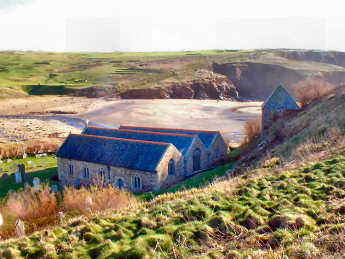
Gunwalloe
and Church Cove
I had an outing down
west in mid-February 2017, primarily to visit Mullion
but also to re-visit delightful Gunwalloe Church Cove on the west side
of the Lizard peninsula, not to be confused with equally charming Landewednack
Church Cove on the east coast of the Lizard. There is some name confusion
here, too, as both are named for St. Winwaloe, also know as Wednack and
commemorated elsewhere too: at Towednack
near St. Ives and at Poundstock near Bude.
I was last in Church Cove in 2010 in the course of walking the whole of
the Cornish Coast Path. Things
have changed a bit; there is now a large National Trust Car Park
with space for 100 cars and, linked to that, the Cove is much busier than
I remember it, even in February. Not surprising, with a sandy beach,
all that parking and, in season, refreshments. Between the car park
and the Cove is Winianton Farm, National Trust property but farmed by Roddas,
famed for their clotted cream. On this occasion I also looked around
Gunwalloe village, a most attractive and surprising place in that half
the cottages are thatched, including Toy Cottage (pictured left) where
Compton MacKenzie, author of Whisky Galore, lived in 1908.
A mile or so north of Church Cove is Gunwalloe Fishing Cove, where the
catch was hauled up to the pilchard cellars on the top of the cliff by
winch, recently enough for one winch to have been petrol driven.
At Chyanvounder, just south of Gunwalloe village is the Halzephron Inn,
a bit gastro-pub for my tastes but not unreasonably priced.
 |
 |
 |
|
|
|
|
 |
The name Gwennap occurs elsewhere. Gwennap Pit may make some sense as it is only about 2 miles away. Here it refers to St. Gwenap or Wenapa. Down on the south coast of West Penwith, the headland looming above the tiny Porthgwarra Cove, featured in the 2016 Poldark Series, is also Gwennap; the name thehe is a puzzle. After you turn off the Falmouth road, the church car park is straight ahead; up a drive to the left is the big house, Trevince. The graveyard is vast, the lych gate in the photo is halfway up it towards the church. Unusually you approach from the north side. The church consists of nave and two aisles. There is no tower but a separate bell tower stands to to south west. When I visited on a Saturday in early November 2016, when I also investigated Carharrack and re-visited St. Day and Gwennap Pit, I was disappointed to find the church locked, despite the usual 'Welcome' notice in the porch. Too often recently I have found churches locked; have those responsible wondered what God might think about his people being locked out of his house? I probably didn't miss much: Pevsner merely refers to rebuilding in 1862 and Cornish historian Charles Henderson took the view that "few Cornish churches are less interesting than Gwennap". |
|
|
From A393 Redruth to Falmouth, signed L at Comford |
| A tiny village on the road from Hayle to Godrevy, Hell's Mouth and Portreath, you are almost through Gwithian before you realise it. But it is worth stopping for a closer look. At the Hayle end of the village are the attractive Gwithian Farm, handsome Churchtown House, a thatched Methodist Chapel, recently restored and the rather ugly Red River Inn which (2015) has apparently had a makeover and is much improved with enterprising food. The inn, originally the Pendarves Arms, was renamed for the river that reaches the sea here, discoloured by mine spoil. At the Godrevy end is another handsome house, Churchtown Farm, and a charming church with a Cornish cross in the graveyard. The church remembers the 5th/6th century St. Gwithian or Gocianus. The saint's remains were said to have been found in the sands in the 19th century but lost again. The present church was originally built in the 15th century. It was rebuilt in 1866 though the tower is original. Gwithian Towans (dunes) lie between the village and the sea. The beach runs from just south of Godrevy Point for three miles to the mouth of the Hayle River. It is popular with surfers, swimmers and families. |  |
| From A30, heading west, take Hayle turning and then Ist right |
|
 |
I had driven past
Halsetown many times, on the B3311 road from St. Ives
to
Penzance, but knew nothing about it except
that it has a car park and a pub. Then, in November 2007, I took
a walk, with my sisters Mary and Frances, that took in Rosewall Hill, Trink
Hill and Halsetown. Fascinated by what seemed to be, unusually for
Cornwall, a planned village, I did a little research and came up with the
following (which I have re-interpreted somewhat) discovered on Genuki and
St. Ives Trust web sites.
James Halse was St. Ives' leading citizen: lawyer, mine owner and peddler of influence. As MP for St. Ives, he was afraid that the Reform Act (passed in 1832), in doing away with 'rotten boroughs', would probably lose him his seat. Determined to continue as an MP, he established Halsetown in the early 1830s as a 'garden village' to house his workers. Each householder had just enough land to qualify to vote. Dependent on Halse for their jobs and homes, they all voted for him and he retained his place in parliament. I haven't yet had the chance to explore Halsetown properly but it looks like a fascinating place with its series of 'green lanes' lined with attractive cottages. (I returned a couple of weeks later to explore more fully.) |
|
|
On B3311 St. Ives to Penzance. |
 |
We have a soft spot for run-down places - early industrial sites and shabby towns like Bude and Portreath. Despite proximity to colourful, lively St. Ives, Hayle has something of both. It takes its name from the estuary ('heyl') on which it stands. From prehistoric days of tin and copper trading it was a trans-shipment point, providing safe passage for men and materials across the peninsula to the port at St. Michael's Mount, avoiding the perils of Land's End. In early Christian times missionaries travelled through on their way from Ireland and Wales to Brittany. There was no town until the 18th century when copper smelting and heavy engineering, later explosives manufacture on Upton Towans created a boom town. The Cornish Copper Company is long gone but there are still remnants of Harvey's great foundry that built the massive beam engines for the mines, built Richard Trevithick's steam locomotives and later built ships. Harvey's remained in business well into the 20th century and Hayle continued as a port until the 1970s when the power station closed. The derelict former foundry buildings are now the centrepiece of a vast regeneration project going on in Hayle. In addition to the foundry, financial multi-national ING plans to regenerate the harbour area. King George V Memorial Walk, on the north side of Copperhouse Pool, has been colourfully restored. Walk to the head of North Quay to enjoy views of sweeping beaches, tall dunes, holiday shacks, St. Ives and Godrevy Lighthouse. |
|
|
Signed from A30, 5 miles west of Camborne |
| It was a dull Saturday at the very end of September. I had been planning to travel down west to Penzance, to find the Cornish Cross in Morrab Gardens, but decided not to take a chance on the forecast rain but to give myself a shorter journey - to Helland, just off the Washaway - Camelford road. It was as well that I did; by the time I left Helland the rain had started. I went first to Helland village, where the church, Old Rectory and cottages stand on a hill. The Old Rectory and Churchtown Cottages were attractive, the latter best seen from inside the churchyard. As so often, the church was closed so I rely on Pevsner but in vain. All he has to say refers to a medievaL font and a 16th century grave slab. I then headed down to Helland Bridge, where a 4-arch, 15th century bridge described by Pevsner as "one of the best in the county", crosses the River Camel. A little way up the hill towards Helland village the Camel Trail crosses the road, on either side of it attractive cottages, Cobblers and Silverstream. A little down the hill is the old forge, now a home with a couple of unusual roof-lights, and across the road a stile into the grounds of Riversmead, home to Studio Potter Paul Jackson. There is little on the other side of the bridge, except the old Mill House and a couple of fairly attractive cottages. |
 |
 |
| Churchtown Cottage, Helland |
Helland Bridge |
Return
to Towns and Villages
Return
to Home Page for Cornwall Reviews Contents
 |
I had been wanting to get to know Helston better for some time so, when Jane and I revisited Godolphin House in April 2007, we took the opportunity to have a wander around the town. Most people really only know Helston for its Flora Day when in May the whole town takes to the streets to celebrate spring with the ritual Furry Dance. There is a lot more to Helston than that - though, while I enjoyed the town's history and architecture, Jane disliked its shops and steep streets. Helston no longer has its former importance. In medieval times it was a stannary town, exporting tin from its own port. A 12th century castle guarded the crossing of the River Cober. But the port was lost when Loe Bar blocked the river mouth, the castle fell into disuse and was demolished, and the tin industry declined. What remains is a legacy of fine buildings. To enjoy Helston's architecture, call into the Guildhall and pick up the excellent Town Trail guide, hot on history. Best streets are broad, steep Coinagehall Street, winding Church Street and Cross Street with its handsome houses. Important buildings are the classical Guildhall, the Market House (now a folk museum), the Angel Hotel (once the town house of the Godolphins), the Great Office on Cross Street, Godolphin Hall, the Grylls Monument and the former prison. There is a large free car park just down the Porthleven road; opposite, at the top of the boating lake in Coronation Park, is the excellent Lakeside café. |
|
|
On A394, twixt Falmouth and Penzance. Helston Revisited |
| A FAVOURITE WALK: We like to park in the large free car park at the Helston end of Porthleven Road and enjoy a coffee at the excellent café by the boating lake in Coronation Park before setting off on this short walk through the Penrose estate to Porthleven. We prefer to follow the track (the old carriage drive) along the shorter western side of The Loe, passing Penrose House on the way to Bar Lodge. From here we simply follow the coast path west into Porthleven, then get the bus from the head of the harbour back to Helston. The walk is a mere 3¾ miles. If you prefer to take the longer east side of The Loe the walk would be about 5¼ miles. Buses from Porthleven go hourly so lunch in Porthleven if the wait allows, or back at the Lakeside café if it doesn't. |
Helston
Revisited
In
mid- February 2017 I returned to The Lizard, primarily to take a look at
the Daffodil Festival at Mawgan--in-Meneage.
First, however, I took another look at Helston, parking in Parc Eglos,
not far from St. Michael's Church. I had really come to find two
Cornish Crosses, so I headed first for the one on Cross Street, a lovely
street with some fine buildings in it. I particularly like the doorway
to a house called "Great Office", pictured below right. I
then walked back up the hill - Helston is very much a town of hills - to
St. Michael's Church, where I found another Cornish Cross on a grave near
the tower. From a distance the church looks conventional enough so
it is something of a surprise to enter and discover a Georgian interior.
The church was built for the Earl of Godolphin between 1751 and 1761.
The interior is dominated by an elaborate balcony and an unusual ceiling
with elaborate coving. There is an unusual and attrective font.
Memorials include a marble one to George Simon Borlase and a small War
Memorial Chapel. In the large graveyard, filled with spring flowers
when I saw it in late February 2017, is an elaborate memorial to Henry
Trengrouse, so moved by the fate of HMS
Anson that he devised his "Rocket" apparatus, precursor of
the breeches buoy.
 |
 |
 |
|
|
|
|
| The
small village, four miles south-west of Liskeard, nestles in a wooded
valley. Oddly, its church and the former
rectory are up a steep hill well above the village with nothing else near. The little River West Looe runs through the
village. The name derives from the Cornish
Hiriard, meaning long ridge, with the village at its foot. This was mining territory and had its heyday in
mid to late nineteenth century,
when considerable quantities of lead and silver were mined. There are still the
remains of mine chimneys, engine houses and mine workings from the four mines
that were active in the vicinity of the village. The Herodsfoot mines were renowned world-wide for
examples of two minerals, bournonite (lead, copper and antimony) and
tetrahedrite, a
sulphide of copper, iron, and antimony. Gunpowder
was manufactured at the Herodsfoot Powder Mill, up the valley to the west of
the village, and the site was used by the explosives industry until the mid
1960s. Near the
old Powder Mill Pond is the Powder Mill itself, externally surprisingly
complete; the wheel-pit is alongside but there is only a hint of the old water wheel. John Betjeman, in his "Shell Guide to
Cornwall" described Herodsfoot as "an inland Polperro in a deeply
wooded valley. Known as a "Thankful" village, it is one of a
handful of such villages in the country in which everyone who went to World
War I came back. A War Memorial in the
centre of the village remembers "those who served". To find the
Powder Mill, take the lane west out of the village and climb the hill to bear
right downhill into the Forestry Commission's "Deer Park
Forest." At the bottom, the mill
pond is to your left, the old Powder Mill to your right. There is a car park and refreshments. Modern holiday cabins on stilts look quite
interesting. On my way leaving Herodsfoot, on a steep lane
heading towards Trevelmond, I pulled in opposite Rose Cottage and got a good
view to the south of Herodsfoot Mine chimney, standing firm but forlorn amongst
the trees. Thankful villages: These are the villages which suffered no losses in World War I. Among 16,000 villages in England, Arthur Mee estimated that there were at most 32 Thankful Villages, although he could only positively identify 24. A Doubly Thankful village is one which lost no-one in either World War. |
 |
 |
 |
| Herodsfoot Thankful Village |
Herodsfoot Church |
Herodsfoot Powder Mill |
Return
to Towns and Villages
Return
to Home Page for Cornwall Reviews Contents
| I had been in Kilkhampton previously but mostly just passing through and once to seek out the remains of a Norman motte-and-bailey castle, down the lane towards Stibb and the Combe Valley. On this occasion, in late August 2016, I was visiting three villages and their churches, the others being nearby Poughill and Stratton. Kilkhampton is a largish village, strung long the A39 north of Bude, with a few shops and a couple of pubs, The London Inn and the New Inn. I enjoyed a bacon roll and a coffee in the latter. In the small square, a war memorial commemorates Lt. Colonel Algernon Carteret Thynne DSO, killed in the Great War. The church is typically Cornish, with nave, two aisles and a battlemented and pinnacled three stage tower. Above the tower door stands a small statue, presumably of dedicatee St. James. The porch has a remarkable feature, a deeply and elaborately carved Norman doorway. Inside are three wagon roofs, higher than is usual in Cornwall, Granville memorials and a coat of arms by a pupil of Grinling Gibbons, and a superb collection of original bench ends. |
 |
 |
 |
|
|
|
|
| This is a charming,
tucked away part of Cornwall, more easily accessed by car ferry across
the Tamar to Torpoint or by foot ferry from Plymouth to Cremyll than from
most of Cornwall. Here on the very south-eastern tip of Cornwall,
the twin villages of Kingsand and Cawsand tumble down their hillsides to
meet at small harbours facing broad Plymouth Sound with long views of Drake’s
Island and the Devon coast. Where they meet at the bottom is the
Halfway House Inn, a comfortable pub with a good welcome, a
good atmosphere and excellent food. Rather surprisingly, until 1830
the Halfway House stood at a county boundary; Kingsand was in Devon,
Cawsand in Cornwall. This is a great place to explore on foot with
steep streets filled with colour washed stone cottages, jostling for space.
Climb high above the Cawsand side to find an old fort, converted to housing
with breathtaking views. Climb above the Kingsand side, past a tiny
village green, to find a gate near the cliff that leads into glorious Mount
Edgcumbe Park with its house with formal garden and Earl's Garden.
There is more good walking around Rame Head to the south. There is
a smallish car park next to the Halfway House and a much larger one above
Cawsand.
Kingsand, Rame Head round walk. Kingsand, Maker, Cremyll round walk. |
 |
| By A38, A374 towards Torpoint, B3247 and un-numbered road |
|
 |
Ladock is a small village which we regularly pass through on our way to Truro. It is pleasant enough, just passing through, but the best is to be found uphill on the east side of the road. My first experience of Ladock was visiting Ladock House Garden, open under the National Gardens Scheme, in April 2007. In June 2016 I parked in the large public car park on the main road through. Here in the car park is the local shop and post office which sells hot drinks, sandwiches and good Cornish pasties. Outside is a decking area with free Wi-Fi. The little Tresillian River flows behind the car park. On the other side of the road is the Falmouth Arms pub, Bissick Old Mill more-or-less behind it. To the north of the pub a path runs streeply uphill to the church of St. Ladoca. The church, standing in a large graveyard, consists of nave, south aisle and pinnacled tower. Inside there are no carved bench ends but the chancel screen seems to made up of them, as does the lectern. Noteworthy featues included windows by Burne Jones, Ford Madox Brown and William Morris, a dark carved font, possibly of Catacleuse stone from the north coast near Padstow. There are some interesting old memorial slabs, not easily readable. Just west of the church, a track leads past attractive Glebe Farm, down into the valley to St. Ladoca's Holy Well. There is a disabled toilet. |
|
|
Ladock is on B3275 Penhale to Tresillian near Truro |
| A long and lovely
wooded valley drops down for about a mile from Trewoofe to reach the sea
at Lamorna Cove. When you get there it is really something of a disappointment:
to your right a short view of wooded cliffs; to your left
a view, only slightly longer, of the debris of a vast former granite quarry;
in the middle a car park, a seasonal café, rental cottages, public
toilets and a small sandy harbour. Frankly, it is all a bit scruffy.
You would do best to leave the car and walk up the steep hill and its side
turnings (where possible) to see what you can of the village. Cottages,
some attractive, some a little ramshackle, are tucked away in woodland
on either side of the lane. Up a side turning is a charming row of
cottages, a little way beyond them a tiny waterrmill. Quarter of
a mile up the main lane is the Lamorna Wink inn, set a little back from
the road and with tables outside. It is a plain place inside but
with a lot of fascinating nautical memorabilia. Welcome is not always
very friendly but food is simple and good value. Three gardens here
deserve to be better known; above the village is Chygurno,
at the head of the valley are Trewoofe
and Trewoofe Orchard. Lamorna's
main claim to fame was as an artistic colony in the early 20th century.
An offshoot of the famous Newlyn School colony settled in the valley here.
It included Lamorna Birch, Laura and Harold Knight and, for a while, Alfred
Munnings. Their work can be found in Penlee
House in Penzance. An antiquities walk from Lamorna. |
 |
| The coast path is easy north to Mousehole, tough heading west |
|
| Down the hill is Church Cove, not to be confused with Gunwalloe Church Cove on the Lizard's west coast. Here the buildings in the cove make a delightful grouping: the old Fish Cellars, an attached Roundhouse, the former Winch House and the old Lifeboat House. It must have been difficult enough to launch cove boats from here, the lifeboat must have been almost impossible. All these buildings are now holiday or second homes. Up the hill is the village and church. The village is attractive with several thatched cottages and a barn with an octagonal extension. As at Gunwalloe, the church is dedicated to St. Winwaloe. He was also known as Wednack and a church at Towednack near St. Ives is also dedicated to him, as is one at Poundstock near Bude. As at Cury, the possibly 13th century church porch is remarkable, like a small chapel with an elaborate doorway. Inside are attractive barrel-vaulted ceilings, a font and lectern both using serpentine stone, a badly worn carving of two men holding a shield, colourful organ pipes, a probable cross base built into a wall, a priest's chair tucked into a squint, and a 15th century font, its donor's name inscribed on it. |
 |
 |
 |
| Elaborate Vaulted Porch |
Landewednack Church |
Serpentine Pulpit |
 |
A small roadside village on the A389. I visited Lanivet in mid August 2016, on a day which included also Bodwen, Lanlivery and Luxulyan. On the road you scarcely have time to notice anything before you are out the other side. On foot there is plenty of interest. In the village itself is the pleasant Lanivet Inn which, at lunchtime does a wide range of simple, reasonably priced food, the excellent Welcome Stranger Fish and Chip restaurant opposite, a couple of small busineses, a free car park and public toilets. Walk up the turning alongside the pub and you come to the church, a handsome, typically Cornish, 15th century church in the Decorated style, ruined by improvement by Victorians, who scraped many frescoes and removed original stained glass. The reason to visit Lanivet church is the superb collection of stonework dotted around inside and out. By the porch is a 10th century 'hogback' tomb slab. Behind the church are a 13th century four-hole Cornish cross and a 10th century wheel cross. Inside the church are some fascinating memorials. One from the 5th or 6th century commemorates 'Annicu'. A portrait tomb slab in the vestry to a Courtney (perhaps related to the Earls of Devon) dates from 1560; another Courtney was added to it in 1632. A nearby tomb slab has gilded angels. Pulpit and reredos are Victorian but attractive. |
|
|
On the busy A389 from Bodmin to the A30 at Innis Downs |
| Easily missed, unless you are walking the Saints Way or looking for a good pub, Lanlivery is a charming backwater on the road to almost nowhere. I found it when I sought out the excellent Crown Inn for some of my American visitors to lunch, in the days when I was still touring. Jane and I have enjoyed lunch there since. You would never guess it now but during the 19th century the extensive, largely moorland, parish was heavily industrialised with tin mining, granite quarrying and even some china clay extraction. The population approached the 2000 mark then; now it is around 500 and would be less were it not for the second homes and holiday rentals. The church, originally dedicated to St. Dunstan, is now dedicated to St. Brevita. Her holy well is in the grounds of Churchtown, part of the Vitalise charity and providing a rural activity centre for the disadvantaged. Restored in 1993, the church is of relatively little interest, though it has some good memorials. Far more interesting is the steep little street that runs down from the back of the churchyard. The attractive Village Hall dates from the 18th century, was first a 'Dame School', later a library. Below that is the former smithy, now a home, and other attractive houses. What appears to be the Crown's car park is, I think public. The uninspiring church had, when I was there, some interesting wood carvings on window ledges. |
 |
| Signed off A390, just west of Lostwithiel |
|
 |
In early September
I visited the village of Lanreath, abour five miles north-west of Looe.
My primary purpose was to look at the church, of which more later, and
to take a look at Court Barton, once the manor house of the Grylls family,
now just a farmhouse. Happily there is a good sized car park by the
village stores and post office - what a lucky village, still to have that
alive and kicking. Sadly, the same could not be said for the Punchbowl
Inn which closed in 2011 and looks very much like staying closed.
But do look out for its entertaining inn sign, presumably made by a local
blacksmith. Court Barton is a handsome, symetrically fronted early
Jacobean house with some massive stone barns. St. Marnarch's church,
its exterior essentially Perpendicular in style and well restored in 1887,
consists of nave, south aisle, north transept and three stage tower.
On your way in, do note the carved roof bosses in the porch. Inside
are more roof bosses and two painted ceilings. A highly decorated
font has an unusual octagonal cover. A board on one wall refers to
Charles I as 'Prince' - in 1635! Another carries Charles II's coat
of arms. The finely carved rood screen retains some medieval paintwork;
in front of it is a carved Jacobean pulpit and lectern. A wall monument
commemorates Charles Grylls and his wife. There is a colourful modern
altar cloth. (July 2020, Punchbowl appears empty, fopr sale) |
|
|
Just off B3359 Middle Taphouse to Looe road. Signed. |
 |
My earliest memories of Launceston are of an ordinary little town with a terrible traffic problem. That was in the 1950s when there were no decent roads into Cornwall. Now that the A30 bypasses the town, Launceston has regained the character it had before traffic congealed its arteries. We have visited twice recently - once for antiques (there are none that we could find) and then for quilting exhibitions. The quilts were wonderful - in St. Mary's church and at Cowslip Workshops at a nearby farm on the road from Egloskerry. Jo Colwill started Cowslip Workshops when foot-and-mouth had reduced farm income to zero. You can now learn sewing, quilting, embroidery, drawing and more and there is a shop, a restaurant and a gallery with good exhibitions. Launceston itself may lack good shops but it does not lack interest. The original settlement north of the river, now known as St. Stephens, has a fine church. In medieval Launceston you will find a ruined late Norman and 13th century castle, a 13th century town gate (the town walls are long gone), some handsome churches, notably that dedicated to St. Mary Magdalene, a good local museum in the National Trust's Lawrence House and a narrow gauge steam railway with its own museum. We were pleased to find Launceston much better than expected. Launceston re-visited 2016 |
|
|
Signed from A30, just west of the Devon border |
Launceston revisited in February 2016
| I was back in Launceston in late February 2016. First I drove down to the River Kensey and parked there in the hope of seeing the inside of St. Thomas church. That was closed but the gate to the priory ruins was open. Not that there is much to see, only a small part of the priory survives and that only to the height of less than a couple of feet. There is however a good view of the castle keep on its hilltop. On the way round to the priory ruins, I spotted the base of a massive pillar, presumably from the priory, on it an unexpected Cornish Cross. I would have liked to have looked round the old railway station, from which steam trains run to New Mills, but I was too early in the season for the Launceston Steam Railway. I then headed up the hill to the town centre and parked in a handy multi-storey car park. First I visited St. Mary Magdalen church and got some good interior photos. Among the impressive features are a fine rood screen, a lovely pulpit and good bench ends. But the exterior is the star with its intricate stone carving. Sir Henry Trecarrell is believed to have been responsible for the church's design and construction. But what struck me most about the town was the remarkable number of attractive original shop fronts. That in the photo is probably the best with its barley-sugar twist columns. |
 |
| Back to the first Launceston entry |
|
| In January 2017 I had an expedition down west. First I went to see Towednack church, closed when I was there recently but happily open this time. Then I continued to Lelant where a little research in Langdon had suggested the existence of several Cornish Crosses. I checked on Cornwall Council's excellent Mapping Website and was able to confirm that I should find crosses in the churchyard of St.Uny Lelant, in the large cemetery and even on the main street. Previously I had only been in Lelant when on the Cornish Coast Path between Hayle and St. Ives. On that occasion I had taken the path between the church and its separate cemetery and not lingered at he church. On this occasion I stopped in the town first where, opposite the Badger Inn (formerly the Praed Arms) a Cornish Cross had been built into the wall next to Cross Cottage. There is now a War Memorial on the site but it looks as if the cross head is mounted on top of the memorial. In the cemetery I found 3 crosses; in the churchyard I found a further 2. The church is delightfully situated, next to a golf course and overlooking Hayle and the Hayle Estuary. Of interest in the church are 2 ancient slate memorials, an octagonal font, panelling from a medieval screen and a good reredos. |
 |
| Follow A374 St. Ives to Badger Inn and go forward to Church |
|
 |
Although Lerryn in
only 3 miles from
Lostwithiel, and that
seems the obvious way to approach it, I think that probably the best and
most interesting way to approach the village is to start from
Fowey
and and take the Bodinnick Ferry across the Fowey
River. This way not only will you have a good view of Daphne
Du Maurier's parents' Ferryside home, but you will then travel along quiet
lanes and through the charming hamlet of Lower Penpoll. Lerryn is
clearly a wealthy little village. A number of handsome homes
stand along both sides of the little River Lerryn, a tributary of the Fowey
River. It is effectively a tidal creek, crossed by a medieval bridge
and by stepping stones at low tide. Small boats line the river but
don't move often - the very tidal nature of the river is quite restrictive.
Signs of former industry include lime kilns built into homes and a former
barn (maybe a warehouse) by the river. There is a lovely walk along
the north side of the river to the tiny hamlet of St. Winnow.
Try this walk in spring when the woodland is filled with bluebells and
wild garlic. You can make a round walk of it by returning across
fields to Winnow Mill, then through the National Trust's Ethy estate.
We have enjoyed several good meals in the Ship Inn at Lerryn. There
is a small amount of parking by the river, close to the Ship Inn. Round Walk, Lerryn St. Winnow, Ethy |
|
|
3 mls SW of Lostwithiel; 4 ml from Fowey via Bodinnick ferry |
| The village of Lewannick is about as far east as you can get in Cornwall, just off the fast A30 road and a couple of miles south-west of Launceston. I was there for the first time in April 2017, on a sunny Saturday. It is one of those relatively unusual Cornish villages where the church stands on a island of raised ground, six feet or so above the triangle of surrounding roads. I visited primarily to see two inscribed stones. One, inscribed in Latin and Ogham is in the church, the other is in the churchyard, south of the church. In the church porch, look up to see some unusual roof bosses. Inside are two fonts, one of unusual design with eight receptacles for water and a separate plinth, a carved wood pulpit, a carved stone reredos, and an unusual war memorial screen with painted panels. The chancel has a wagon roof with carved bosses. On the triangle of streets around the church are a pub, the Archer Arms, a former Police House of 1871, attractive Priory House (was there a priory here?) and, partly hidden down its driveway, the manor house. |
 |
 |
 |
| Lewannick Church |
Porch Ceiling Boss |
Inscribed Stone |
Linkinhorne and Stoke Climsland
| Linkinhorne lies to the north-west of Callington, Stoke Climsland to the north. I first encountered these villages way back in 2007 when researching the Land's End Trail. On this occasion I visited both late in October 2016 to complete my researches in the Callington area. Stoke Climsland is pleasant enough but unexceptional. Its church disappoints somewhat. All I could find to enjoy was the attractive, typically Cornish exterior, the studded porch door and the colourful ceilings to chancel and couth aisle. Linkinhorne, on the other hand is an attractive village, centred around its church, opposite which is the Church House Inn (sadly closed in 2016) and below which are the attractive old buildings of Church Farm. On the hedge by the lych gate is an ancient Cornish Cross. The tower is Cornwall's second tallest, after Probus. Inside is a wall painting (unusual for Cornwall) of Christ, rood stairs, carved wooden rood screen and pulpit and a font of Polyphant stone, |
 |
 |
|
|
|
 |
Liskeard is an odd town. First impressions were of dull, boring, mainly Victorian architecture, though I must confess that I visited on a dull rainy February 2016 day on which the dark stone of so many buildings left a dull, uninteresting impression. Previously I had only been in Liskeard (Cornish Lyskerrys, Kerywyd’s Court) on two occasions, once just passing through, on the other seeking a second-hand furniture shop (successful with an excellent buy of oak table and chairs). It is a town of some historical importance, a stannary (tin coinage) town from the 13th century, becoming a chartered borough in 1240. It became boom town in the second half of the 19th century, when most of its major buildings were built on tin and copper profits. The town is also odd in its layout. It stands on two hills, the western containing most of the major buildings, the eastern with Norman and later St. Martin’s church, the second largest in Cornwall after St. Petroc’s in Bodmin. On its north and south walls are thirteen consecration crosses, unique in Cornwall. Barras Street, The Parade and Pike Street have most of the other major buildings: Webb’s Hotel, Stuart House with its museums about the Civil War and about Henry Rice, major mid 19th century Liskeard architect, and excellent tile-hung small Town Museum next to Foresters Hall. In Well Street, off steep Pike Street, is the 16th century town well with its four outlets. Liskeard Revisited |
|
|
Signed off A38, 13 miles E of Bodmin; ample parking |
| A few days after my first visit to Liskeard, I went back, this time with Jane. We were blessed with a lovely sunny day. Consequently we covered much more ground than I had covered on my first visit. We parked in Westbourne car park; delightfully we left it by Pig Meadow Lane, passing some intereresting murals, including one with Trethevy Quoit and an engine house. We wandered round all the streets of interest and climbed the eastern hill to visit St. Martin's church. The view to the south front of the church is impressive: an elaborate 4-stage tower with crenellated parapet and large windows with Decorated tracery. Inside, the church has nave and two aisles, the southern effectively a separate chapel with its own screen and a fine collection of carved bench ends. In the graveyard, at the east end of the church is a simple Cornish cross. By the northern lych gate is an attractive house, Church Cottage. On our way around town we were struck by just how many interesting buildings there are. On Well Lane we were shown round an ancient warehouse, still with its winding gear, almost opposite the Pipe Well. Elsewhere, sadly, we ancountered a handsome Georgian building, empty and going to rack and ruin. We managed to find suitable places for both coffee and lunch in, respectively, Fat Frog on Market Street and Bean on Fore Street. I was really pleased that second impressions were so much better than first. We shall visit Liskeard again. |  |
| Back to Liskeard |
|
Looe - a change of heart on a south coast resort town
| When I originally
reported on Looe a few years ago, I was very harsh about it, really seeing
only the tourist tat. In March 2009 I was in Looe when walking the
Smugglers Way. I spent some time walking around the more interesting
bits and taking a number of photos. Chris Halls, who runs the 'I
Love Looe' website, had taken me to task about my scathing judgment on
his town. Having been back in Looe and looked at it through different
eyes, I am now happy to revise my original view - though not entirely.
Looe comes in three parts. Divided by the River Looe are East Looe,
the town's main resort and shopping area, and West Looe, residential and
poor shops. The two are joined by a handsome many-arched bridge.
Beyond West Looe is smart residential Hannafore with a beach. East
Looe has an attractive waterfront with a major fish market, serving Cornwall's
second largest fleet (the fish is said to be the best), handsome converted
warehouses and the new lifeboat station. Behind these are the charming
guildhall and old lifeboat station. Shops and restaurants look better
than I remember (but many seem to close in winter) and I have had good
fish and chips in Looe. There are lovely walks through Kilminorth
Woods along the West Looe River. But, I'm sorry, I still don't like
Looe's tatty touristy shops. More on Looe Another view of Looe Chris Halls' I Love Looe |
 |
| Banjo Pier is southern terminus of the Smugglers Way |
|
| PARKING IN LOOE: Perhaps this is really why I don't really like the town. There is a vast car park at Mill Pool on the western approach. It is expensive and only as you walk into town do you discover that you could have parked much more cheaply in Pearns boatyard. There is parking by the quayside in East Looe but it is even more expensive and usually full of shoppers taking advantage of the cheap short-stay rate. We prefer to park free in Hannafore and walk. |
 |
Since my original report on Looe, I have passed through it a few times, walking the Cornish Coast Path, but have not spent much time there. So, in early May 2016, Jane and I parked a the far end of Hannafore, walked round to West Looe, where we enjoyed a powerful coffee at Tasty Corner, a café/restaurant, new to us, with a view across to East Looe. We continued round, over the many-arched Looe Bridge and into East Looe. We wandered around the town, surprisingly busy with visitors though still very early in the season, and debated lunching in the Salutation Inn which we had enjoyed on our last visit, but decided to cross back to West Looe and eat at Tasty Corner. So we took the little ferry across the river - a little precarious getting on and off for us older folks - and enjoyed an excellent and reasonably priced lunch. Jane had a delicious and well filled crab sandwich while I had their fish and chips; fish, batter and chipe were all excellent. We walked back round to Hannafore, where we had hoped to get tea and coffee; unfortunately the kiosk was closed for some unknown reason. I realise that on most previous visits to Looe the tide has been out. This time the tide was in, the sun was out so, happily, I was able to get some decent photos. |
|
|
Back to main Looe entry |
 |
This small Cornish
town has a lot to offer – history, charming unspoiled streets and the county’s
best concentration of antique shops, varying from quality to bric-a-brac.
Once Lostwithiel was a place of considerable importance. At the end
of the 13th century Edmund Earl of Cornwall rebuilt the castle in stone
and Lostwithiel then became the administrative centre for the county.
It had a port on the River
Fowey, exporting tin, the trade in which was managed from the Stannary
Court in the Shire Hall, which also operated as the County Treasury.
When the Earl of Cornwall was made Duke, the Shire Hall grew into the Duchy
Palace. When the river silted up in the 15th century, Lostwithiel
lost its tin trade but developed others, pottery, weaving, tanning and
pewter-making. St. Bartholemew’s church has an unexpected spire
of elaborately carved granite. Unusually, the streets form a grid
pattern, originating in medieval times. Fore Street has the shops
and tea rooms. Quay Street, by the River Fowey, has former lime kilns
at one end, at the other the remains of the old Duchy Palace, behind the
heavily buttressed former ‘Coinage Hall’. Across the river, a new
apartment development utilises Victorian railroad buildings.
Restormel Castle is up a country lane, a mile to the north of town. Built as a huge circular keep with moat, it was rebuilt by Edmund Earl of Cornwall around 1280 and was later a home of the Black Prince. If you are here during the day, there are a couple of attractive tea and coffee shops – Muffins and the Duchy Coffee Shop, both on Fore Street – and several pubs. Best of the pubs are the Royal Oak on Duke Street, above the main road, and (our preference) the Globe at the bottom of North Street, close by the medieval bridge. There are several attractive restaurants, mostly open only in the evening. LOSTWITHIEL REVISITED |
|
|
On A390 12 miles west of Liskeard |
| UPDATE
JANUARY 2016 - THE OLD DUCHY PALACE:
The Coinage Hall, the major remnant of the Old Duchy Palace, also known
as the Stannary Palace, has undergone major restoration . Closed
to the public for more than a century, the Grade I listed medieval building
was purchased by the Prince's Regeneration Trust in 2008 and has undergone
a major restoration. It has re-opened as offices and shops. Promised museum now in old Corn Exchange. |
| In January 2016, I had time in hand after taking a look at Bradoc and decided to eat my sandwiches by the River Fowey in Lostwithiel. My intention was then to visit St. Bartholemew's Church for the first time. Unfortunately, although both a very clear sign outside the church and the church's own web site proclaim it's opening from 10 to 4 from Monday to Friday, every entrance was firmly locked. [I subsequently emailed the the Rural Dean, in charge while a new incumbent is awaited, asking about opening of St. Bartholemew's, and also of Bradoc church, but failed to receive the courtesy of a reply] I trust I shall be able to find it open on another occasion. In the meantime, I can only report that Pevsner devotes more than a page to St. Bartholemew's, especially admiring its magnificently detailed spire. Disappointingly, he appears to have missed the lantern cross by the porch and a much deteriorated Cornish Cross. Pevsner is also disparaging about the town, dismissing it as having "not much character". I find it a charming place with interesting shops, cafés and restaurants as well as Jeffreys Auction House, a regular on BBC2's Flog It. On this occasion, for the first time, I crossed the river to walk around Brunel Quays, I. K. Brunel's former railway engineering works, converted to expensive and attractive waterside housing. |  |
| Return to Lostwithiel |
|
 |
I have long been familiar with the Luxulyan Valley and Jane and I have enjoyed many walks from Ponts Mill to the Treffry Viaduct, heading up along the river past J. T. Treffry's China Clay Works and returning on the other side of the valley past the impressive Carmears Wheelpit. It is a delightful walk through lovely beech woodland. I had been in Luxulyan village on only a couple of occasions, both when walking the Saints Way. On this occasion in mid-August 2016, Luxulyan was one of group of visits; first I visited Lanivet for the church then I stopped in Lockengate to photograph a roadside Cornish Cross. Then, still heading for Luxulyan, I continued by way of Bodwen and Lanlivery. The first attraction of Luxulyan is its churchyard, for the lych gate with its Cornish Cross and its lantern cross. The second attraction is the Holy Well below the church, restored but sadly not in water. The church itself is almost certainly on an ancient site, a small promontory at the top of a steep hill overlooking the valley. It has nave, two aisles and a three stage battlemented tower, typically Cornish. There is nothing special about its interior, except for the attractive font and the colourful altar. One more thing about Luxulyan - it is pronounced Luxillian. |
|
|
Follow signs for Luxulyan from A391 S from Bodmin |
 |
Madron lies a little to the north of Penzance, just off the road to Bosullow Common, Lanyon Quoit, Men-an-Tol and Nine Maidens Common. As you drive through you are hard put to decide where to park but, if you head for the church and school, there is ample parking. There is more here than just an impressive church: within the churchyard are two impressive memorials - a great mausoleum to Rose Price and a globe-bestriding statue with an unreadable dedication - and two Cornish Crosses (there are two others nearby). Inside, the roofs have carved wooden bosses, there are two attractive screens and the south chapel has an alabaster plaque of saints, some ancient bench ends topped by beasts. High on a wall is the "Nelson Banner", carried in the procession that celebrated Nelson's victory at Trafalgar. In addition to the two Cornish crosses in the churchyard, there are two others nearby, one in a field to the south of the church at 45436/31503, the other on a lane near Madron Well and Chapel, at about 44512/32541. Well and Chapel are worth visiting, the former a spring identified by trees adorned with strips of cloth, interceding for family or friends, the the latter substantial but roofless. Both sites are cared for by the admirable Cornwall Heritage Trust. Nearby is the National Trusts' lovely Trengwainton Garden. |
|
|
Signed from the Heamoor roundabout on the Penzance by-pass |
| Although the Lizard is the best part of an hour and a half's journey from Wadebridge I decided it was high time I visited and reported on several churches down there. I was in Manaccan and St. Anthony in mid February 2019. In addition to these I propose to report on Mawgan-in-Meneage and St. Martin-in-Meneage. An odd word "Meneage", it means "Monk's land" so would have been the property of a monastic settlement. Manaccan is a pleasant small village on a hill not far from the eastern end of Gillan Creek. At one time the village had pub, shop and post office. All closed in 2014 but, in a remarkable show of co-operation, the villagers got together to save and re-open the pub. After some more ups and downs, the New Inn is open again and is a pleasant spot, serving good food; on an adjacent wall are mounting steps. A couple of hundred yards away is St. Manacca's church. The first thing you notice is a fig tree growing out of the west end of the south wall, believed to be 250 years old and surely unique in Cornwall. The next thing you notice is the unusual south doorway, essentially Norman although the arch above has been remodelled. Inside is a plain font, believed by Pevsner to be a late-medieval copy of a Norman original. Stained glass appears medieval but is late Victorian. A simple pulpit may be 20th century. In the chancel two chairs are made from 15th century timber, taken from the former rood screen. A surprise is the carved and colourful ceiling bosses, undoubtedly modern since they include a butterfly and a terrier. |
 |
 |
| Manaccan , St. Manacca's Church |
New Inn, Manaccan |
| Marazion is not a
place you pass through on the way to anywhere. So all who go there
do so for a purpose. Mostly that purpose is to visit Saint
Michael's Mount or to enjoy the beach with its view of the Mount
and of the broad sweep of Mount's Bay. But Marazion is an interesting
place in its own right. A narrow main street curves down from the
east, from the Helston to Penzance main road, petering out soon after it
passes the main car park. Along its way are attractive cottages,
a charming small square, a couple of pubs, tearooms, shops (including Philps
Bakery, renowned for its pasties), and several art and craft galleries.
Pubs are the Godolphin Arms, also a hotel, and the King's Arms. We
enjoy the view from the bar of the Godolphin but find it impersonal.
We far prefer the cozy King's Arms with its friendly welcome and good value
food. Marazion has a remarkable history and may be one of Britain's oldest
towns. It and St. Michael's Mount may have been known to the Romans,
who would have traded for tin here, as Ictis, though some authorities
dispute this. The major town of West Cornwall, from 1170 it returned
two members to Parliament. It was incorporated by royal charter in
1257, a charter reaffirmed by Elizabeth I in 1595. Its importance
is seen in its two former markets, the marhas vean (little market)
and marhas yow (Thursday market), the latter giving the town its
name.
Marazion is the southern terminus of St. Michael's Way |
 |
| Marazion is signed from A394 Helston to Penzance |
|
 |
A couple of miles south-east of Bude, Marhamchurch is a fairly large village of some 700 souls. It stands at the top of a long hill which mirrors the line of the former Bude Canal inclined plane. The broad main street seems to have no name. There is a primary school, a church, a shop, the Bullers Arms pub, and attractive cottages near the church. I was first there when exploring the route of the old Bude Canal, which ran for 10 miles from Lower Tamar Lake to Bude; a very pleasant walk, interrupted here and there where the canal has been lost to private land. On this occasion I went to look at the church. It consists of nave, aisle, transepts and three-stage pinnacled tower. A simple lych gate, with a pyramidal slate roof, leads to the church. Inside are typically Cornish wooden barrel vault ceilings with carved bosses, a wooden pulpit with an unexpected tester, and a large Royal Coat of Arms. The wooden roof of the north aisle is 15th century, the others 19th century. There is a fine 17th century pulpit with tester. The Royal Coat of Arms is large and of plaster work. In the main street, the Bray Institute is in Arts and Crafts style and a former National School incorporates granite doorways from demolished almshouses.. Cottages near the church are attractive. |
| St. Marwenna's Church |
Signed from A39 at Helebridge |
Return
to Towns and Villages
Return
to Home Page for Cornwall Reviews Contents
Mawgan-in-Meneage
I
give Mawgan-in-Meneage, hidden away on The
Lizard, its full title to avoid confusion with St.
Mawgan, whose full title is Mawgan-in-Pydar, near St.
Columb Major. I visited the village for its Daffodil Festival in
February 2017, on a day when I had first been to Helston
for another look around. On my way to the church I stopped first
on the village green (unusual for Cornwall) for a photo of the Inscribed
Stone (below left). At the church I was most impresssed, not just
by the displays of daffs - which were lovely - but also by the organisation
by the local ladies. Parking for the disabled was close to the church;
regular parking was in a nearby farmyard with short access to the church
by a cattle stile into the graveyard. Teas were available and for
those in need of something stronger, the Ship Inn is just down the lane.
 |
 |
 |
|
|
|
|
| In early June 2017 I made a couple of expeditions down to the other side of Falmouth. I was actually looking for a memorial stained glass window by Glenn Carter, commemorating someone named Steve. Jane's sister, who spotted the item in a newspaper, thought it was in Mawnan Smith church. This is a Victorian church just off the road to Mawnan. Although there was some passable Victorian glass, the Glenn Carter window was not there. I wonder where? Except for an odd little bell tower at the west end, the church was otherwise of little interest. On to Mawnan, where the first thing I noticed was the lovely view from the south side of the churchyard over the mouth of the Helford River to Nare Head. The first thing to take your notice is the lych gate, complete with coffin rest and a Cornish inscription which translates as "It is good for me to draw nigh unto God". Inside is a 15th century octagonal Font, a 17th century Alms Box and part of a 15th century Screen. There is a Cornish Cross in the churchyard. I was in the area on a couple of occasions and also visited churches at Budock and Constantine. At Budock there are three Cornish Crosses and some interesting tomb markers. There are, unusually, two lych gates; the rear one has collections of primitive lawn mowers and watering cans. Constantine church has panelling from a former screen, a simple font and a finely carved pulpit. Rood stairs are still in place. |
 |
 |
 |
 |
| Mawnan |
Mawnan Smith |
Budock |
Constantine |
 |
I only discovered Menheniot [the name means Hyniet's land according to Craig Weatherhill, St. Neot's place according to Julyan Holmes - take your choice] towards the end of April 2016. Jane wanted to see an exhibition of Norman Hartnell's designs and materials, being held in the church. I drove her there and quite liked the look of the village so, a week later, I had an outing to explore the village. It was a dull day so photos were disappointing but I still enjoyed the village. There are some good homes and cottages: I particularly liked the Poads Trust cottages and the old Police Station. The church is typically Cornish in that it has nave and two aisles, Perpendicular windows and fine wagon roofs with carved bosses. Less typical is the spire, not seen on many Cornish churches, set on a tower old than the body of the church. Sadly, inside little that is original remains thanks to over zealous Victorian restoration. However, the font, of Caen stone, is medieval and a brass by the pulpit dates from 1386, perhaps Cornwall's oldest. Memorials mostly commemorate Trelawneys. The churchyard is of little interest - no Cornish Crosses - but does contain a grand Vestry building. There is, apparently a holy well to the south of the church but somehow I missed it. |
|
|
From A38 eastbound, pass Liskeard, take 1st or 2nd turn on left |
| Before visiting Callington in October 2016 I first took a look at the little villages of Merrymeet (what an odd name, probably Saxon meaning a pleasant meeting place, according to Craig Weatherhill) and St. Ive Churchtown (not to be confused with St. Ives). Neither is of any consequence. Merrymeet has a small modern church, a mission church under Menheniot parish. There is an unusual small organ and a small altar on granite columns. St. Ive Churchtown (there are also St. Ive Cross, St. Ive Keason and St. Ive Parkfield) has a pleasant church with carved roof bosses in nave and aisle roofs, an attractive altar and reredos in the south chapel, and a carved as well as painted Royal Coat of Arms. |
 |
 |
|
|
|
| According
to one authority Merther translates as the burial place (perhaps of a martyr). In this case, referring to the tiny settlement
in the middle of nowhere near Helston and Gweek, it probably refers to a chapel
of St. Uny which once stood here. Uny,
or Euny, appears elsewhere in Cornwall.
The Georgian church in Redruth Churchtown is dedicated to St. Euny, as
is a well and iron age settlement, Carn Euny, to the east of Chapel Carn
Brea. The church in Lelant, near St.
Ives, is dedicated to St. Uny. Merther
Uny is an isolated place, reached by what OS103 shows as a bridleway though it
is actually a perfectly good track. It
consists of Merther Uny Farm, substantial and attractive Merther Uny House,
which apparently incorporates part of the former chapel, and a couple of
cottages. The old Chapel is long gone
but, where it stood is now woodland with a probably extremely ancient four-hole
Cornish Cross, possibly in fact originally a pre-Christian inscribed stone. Another, simpler, Cornish Cross stands about
200 yards south of this, on a lane running east-west. Confusingly, there is another Merther, this
one with the disused and neglected church of St. Cohan, on the east side of the
Tresillian River. |
 |
 |
 |
| Merthyr Uny Cornish Cross |
Merthyr Uny House |
Meruny Cornish Cross |
Return
to Towns and Villages
Return
to Home Page for Cornwall Reviews Contents
 |
From the photo on
the left you would think Mevva (as the Cornish call it) entirely a delightful
place: busy harbour, old cottages clustered around it, large
newer homes above. I used to think so and I used to drive American
visitors down Cliff Hill, along the harbour, and up Tregony Hill on our
way to Heligan Garden.
I had never really lingered there before so I got something of a shock
when I parked by the harbour in February 2005 and took a walk around.
I concluded that Meva is a bit of an odd mixture, rather spoiled by its
own success. Once a charming small fishing village, in the 20th century
it has been over-run by modern development and the worst of cheap tourism.
The harbour is still a delight - if you don't look at the cheap cafes and
shops - and it is still Cornwall's third busiest fishing port. But
it is definitely not a place to spend much time in. However, if you
follow the narrow street southwards and climb Polkirt Hill, (great overview
of harbour and coast, looking back from here) you come to Port Mellon.
Here is a quiet cove with a boatyard, a decent pub and second homes clustered
around. Continue and walk left up a lane and you come to photogenic
Chapel Point, its whitewashed buildings looking rather like a small Mediterranean
monastery. Continue along the coast path and you will soon find yourself
in Gorran Haven. |
|
|
Now please read Clare Harrison's view of Mevva. |
|
I moved
to Mevagissey in 2012 and during that time have been favourably impressed with
how the village has improved. Your 2005 review no longer reflects how the village is, so I thought to offer an update. Shops and cafes are now of much higher
quality: Tea on
the Quay, The Teapot and She Sells all offer top quality food
and home-made cakes. Gift shops no
longer sell tourist tat, but are largely craft based and tasteful including the
Roberts Cooperative of Craftspeople. There is a high quality deli too. There are some fine restaurants with good
reputations: The
Salamander is very high quality. The
experienced couple who took over The
Sharksfin on the harbour 5 years ago serve interesting fresh food all day,
excellent staff and service, tasteful arty seaside decor. They have also opened The Longstore (yes, Jane and I liked it) in neighbouring Charlestown.
The
Alvarado, run by Antonio from Portugal, using the catch from his own
fishing boat is right on the harbour and is authentic and excellent. There are now 13 restaurants and 6 pubs in
Mevagissey plus several tea shops and cafes. The chef-run Fisherman’s Chippy is is excellent:
griddled fish (garlic scallops for example) as well as the usual deep fried
fish. Mevva has a lower percentage of
2nd home ownership than most Cornish coastal towns. As an active fishing port there is
a thriving community of young families and even in winter it is a nice
place to visit because it isn’t “dead” thanks to the high proportion of
permanent residents. In the summer it is
busy: people come for boat
trips on the fishing fleet or on the beautiful, recently refurbished Seas the Day but, unlike Padstow or St
Ives, the village doesn't get overcrowded. Many people visit Mevagissey because it's near The Lost Gardens of Heligan, walking distance up an attractive
valley. The TIC is in Hurley’s Bookshop; Liz
Hurley is very well informed as author of several walking guides and local
history books. The volunteer-run Mevagissey
Museum celebrates 50 years in 2018 and now has official museum accreditation. Mevagissey Feast Week in June and the
Christmas Lights and New Year celebrations are all run by volunteers with
voluntary contributions and are very successful. Visitors enjoy Mevva for its authenticity as
a working fishing harbour, for being less touristy and over-gentrified than
some of the other seaside fishing villages, for its wide choice of good
restaurants, cafes and pubs and for its good quality accommodation including super B&Bs. |
 |
 |
| Mevva harbour from Middle Wharf |
The Ship Inn in Mevva |
Return
to Towns and Villages
Return
to Home Page for Cornwall Reviews Contents
| On a soaking wet late November Saturday I had an outing down south-east. I went to Millbrook first where I had hoped to look inside All Saints Church. Unfortunately it was firmly locked so I had to content myself with exterior photos, the church looking very gloomy and foreboding on such a dark and rainy day. Millbrook is quite an interesting village, centred as it is around a large lake. It has quite a history, having once had a fishing fleet, a tide mill, a gunpowder factory, a ropewalk, lime kilns, boat building and a large brewery. I had hoped to look inside late Victorian All Saints Church but it was firmly locked. From the outside impressions are of a massive and rather gloomy looking building, built of a dark grey stone. Pevsner describes it as follows: "solid but dull Perpendicular and built of Plymouth limestone with Polyphant dressings." Ceilings are wagon roofed in the late medieval style. Stained glass is all of the turn of the 19th century. I hope to find an occasion when the church is open; if so, I shall report further. |
 |
 |
| Millbrook, All Saints Church |
Millbrook, Molesworth Terrace |
Return
to Towns and Villages
Return
to Home Page for Cornwall Reviews Contents
| Although Mitchell never benefitted from Cornwall's many mining booms, in its time it was a town of some importance. Set in a rich lowland farming area, it was also an important staging post on the main coach road from London. From the look of them it's a reasonable assumption that both the attractive Plume of Feathers inn and nearby Raleigh House were once coaching inns. There are other attractive buildings in town, too: the delightful Georgian Wellesley Farm and a row of cottages on the main street. Politically, Mitchell also once had its importance. You may wonder at the names Raleigh and Wellesley in a minor Cornish town but there is, in fact, a very simple if surprising explanation. From 1547 to the Reform Act of 1832 it was a 'rotten borough', it's very few property owning voters returning two members to parliament. Indeed, in 1593 Devon born Sir Walter Raleigh was one of these as in 1807 was Arthur Wellesley, later Duke of Wellington. I remember well when the main road to holiday country of St. Ives and Penzance passed right along Mitchell's main street. Then the holiday season must have made it a traffic nightmare for its residents; now Mitchell is bypassed by the modern A30 and is a sleepy attractive village. |  |
| Signed from A30, 15 miles west of Bodmin |
|
 |
A small village, population only around 500, Mithian lies just over a mile to the east of St. Agnes and is signed from the Chiverton Cross to St.. Agnes road soon after the Chiverton Inn. It is an attractive village with two notable buildings. The pub, the Miners Arms, has quite a history. Built in the 16th century, it has had a chequered career as courthouse, coroners court, smugglers lair and even apparently a house of ill-repute. The other notable building is Harmony Cot (just out of the village) which was the birthplace of John Opie, the famouir Cornish society portrait painter. A self-taught prodigy, by the age of twelve he had not only learned to draw but had apparently mastered Euclid and was teaching writing and arithmetic - and all this while apprenticed to a wheelwright. Harmony Cot is a private home and not open to the public. There is no Anglican church in the village and the former parish church of St. Peter is over two miles away at Chiverton Cross. Built in 1861, by architect William White, in 2006 it closed, faced with a repair bill of almost £1 million. I had expected to see it crumbling but, in December 2016, after a visit to St. Agnes, it appeared to be undergoing restoration. Oddly, the primary school is also out of the village, at Barkla Shop. The Miners Arms pub in Mithian (pictured left) is strongly recommended: young enthusiastic staff who happily prepared me a not-on-menu bacon sandwich. |
|
|
Signed from B3277 Chiverton Cross to St. Agnes |
 |
Comparatively inaccessible
but definitely well worth going out of your way for, Morwenstow is Cornwall's
most northerly parish; it is the 'holy place of St. Morwenna'.
There are two tiny hamlets, Crosstown and Morwenstow. Crosstown is
a collection of farms around a large village green, one incorporating a
small pub, the Bush. Two tiny bars have half-a-dozen tables and a
short, simple and inexpensive menu. A little further on towards the
coast is Morwenstow Churchtown. Here are just a church, the former
rectory, Rectory Farm, offering teas in summer, a couple of holy wells
and Parson Hawker's famous Hut on the cliffs. In the churchyard
are a Cornish cross, the figurehead from the 'Caledonia', wrecked off Higher
Sharpnose Point, masses of daffodils in spring and, at the top, St. John's
Well, accessed separately. A Norman doorway leads into a church
with Norman arcading, a medieval fresco and some handsome carved bench
ends. Most famous incumbent was Robert
Stephen Hawker, vicar for 40 years from 1834.
|
|
|
|
Signed by narrow lanes from A39 north of Bude |
 |
With a name like that
(it is pronounced Mowzle) it would probably be famous anyway but is notable
for its tiny enclosed harbour, granite cottages, little courtyards and
flower-filled gardens - and a few tales. In 1595 the village was
devastated, as were both Penzance and Newlyn,
by a Spanish raid; the only building unscathed was a pub. In
some unknown year, dreadful gales prevented the village’s fishing boats
putting to sea. With the villagers almost starving, Tom Bawcock braved
the storm to return with a massive haul of seven types of fish. His
feat is celebrated every 23rd December when all Mousehole eats ‘Starry
Gazy Pie’ (or stargazie), assorted fish heads looking heavenward through
the crust. At this time, Christmas, Mousehole's lights
are something to see.
|
|
|
|
Follow coast road south from Newlyn harbour |
| I looked around Mullion in February 2017 after re-vositing Gunwalloe Church Cove. I must admit that my look-around was not very thorough; esentially I just looked in the church then had a coffee in the friendly Old Inn opposite (there is a donation car park handy for both). Mullion has a population of around 2000, village proportions, but with Anglican, Methodist and Catholic churches, a secondary school, a fair range of shops including baker, grocer, newsagent, pharmacy, delicatessen, post office, off licence and clothes, plus pub, cafés, rsstaurants and tea rooms, it has most of what you expect of a town. The largely 15th century church is noteworthy for its 40 early carved bench ends and for its screen which stretches across nave and two aisles. As you enter the porch, note the St. Christopher statue over the door and the dog gate in the door. But what is best known, and mosty visited, about Mullion is not the village but the harbour, a mile away at Mullion Cove. The National Trust owns the little harbour at Mullion Cove. For a National Trust location some of the buildings are a little tatty and you need to catch it on a sunny day, preferably without too many visitors, really to enjoy it. The future of the harbour is a little uncertain. It tends to suffer storm damage and the Trust's policy is one of "managed retreat". |
 |
| From Helston use A3083 Lizard. At Cross Lanes, R to Mullion. |
|
Mylor Churchtown and Yacht Harbour
 |
To many this is just
Mylor Yacht Harbour, a major yachting and watersports centre where Mylor
Creek joins Carrick Roads. With yacht club, large marina, extensive
moorings, renowned boatyard and bars and restaurants, that’s understandable.
As a result of the Harbour’s success property prices are among Cornwall’s
highest and large houses spread along Mylor Creek. However, for others,
this is Mylor Churchtown – to distinguish it from Mylor Bridge – and the
main interest is the church of St. Mylor, quite unnoticed by much of the
boating fraternity. One of Cornwall’s oldest holy sites, the first
church is said to have been founded before AD411 when St. Mylor was martyred
here. A charming church, set in a steeply sloping churchyard, there
are two Norman doorways but the body of the church is essentially of 13th
and 15th centuries. There are remains of a 15th century painted rood
screen, an Elizabethan pulpit and a puzzling priest’s chair, reputed to
have come from nearby Glasney College, closed when Henry VIII dissolved
the monasteries, of 1000 year old Irish bog oak with Norse carving and
Tudor panelling. The churchyard, lych gate at the top, small iron
gate on the quay, is most enjoyable, Steeply sloping, it contains
a free standing bell tower, St. Mylor’s holy well, a Cornish Cross that,
if the whole shaft were visible, would stand 17’ 6” high, fine wild flowers,
and ancient tombstones, one commemorating the 200 who died when Queen
was
wrecked on Trefusis Point. Mylor Church - Walk from Churchtown |
|
|
From A39, just SW of Perranarworthal, 2nd L, follow signs |
| Adjacent Penzance
is
the biggest resort on the south coast of Cornwall, but Newlyn is said to
have the third largest fishing fleet in Britain. First impressions
are of a gritty working town but there are some quite attractive cottages
in streets running up the hill. Focus, of course, is the harbour
from which about a hundred boats operate. The fish auction starts
at 8 a.m. each day and sells around 10,000 tons of fish a year. Pilchards
were once the mainstay but the old Pilchard Works is now apartments.
There is a modern art gallery at the east end of town. Oddly, if
you want to see Newlyn School artists, you will have to go to Penlee
House gallery in Penzance. Just south along the coast is
Mousehole.
Newlyn Revisited
|
 |
|
| Follow coast road south from Penzance |
|
|
I revisited the fishing harbour town
of Newlyn shortly before Christmas 2017 as an addition to a first visit I made
that day to St. Hilary Churchtown.
Parking is very convenient, right in the centre and just across the road
from Warrens Pasty Shop. I was there to
see what changes had been made on The Coombe, the street that leads up to the
main A30, and to take a look in St. Peter's Church for the first time. What struck me first was how much better the
centre of town looks now than last time I was there, several years ago. Redundant buildings on the east side of The
Coombe are now a handsome apartment block;
opposite a former works building has become the Cinema, complete with bar
and cafe. I was disappointed to see that
Aunty May's was closed; Jane and I have
enjoyed fine pasties from Aunty May and, happily, closure was only temporary. I walked around as much
of the harbour as I was able, though that was limited by barriers as the fish
market was closed. Several trawlers were
tied up in the main harbour, many more on the pontoons in the South Harbour but
the place was deserted, perhaps not surprising just before Christmas. |
 |
 |
| Newlyn Pilchard Works Apartments |
Newlyn Cinema |
Return
to Towns and Villages
Return
to Home Page for Cornwall Reviews Contents
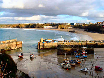 |
An odd mixture of
tawdry down-market resort and delightful cliffs, headlands and beaches,
this is a place best seen on foot along the waterfront. Two hundred
years ago just a mining and fishing village, the railroad then brought
wealthy visitors and grand hotels. Lapsing to down-market in the
20th century, Newquay's discovery as a surfers paradise (Fistral is the
major surfing beach) has seen much improvement. A Huer's Hut was
once the look-out tower for pilchard shoals. The eight-man pilot
gig is now raced; once the gigs competed to get their pilot
to incoming boats first. One aspect of Newquay of which I have no
experience is its nightlife. I am happy for it to stay that way.
I am told that the many clubs and nightclubs seethe with action at night,
much of it drunken and troublesome.
|
|
|
|
For town take A3059 from A39; for Fistral beach take A392 |
 |
Late in September 2016 I made an expedition to the other side of Truro to look at Loe Beach, Feock village and church, Old Kea and Kea, tha latter two no more than hamlets. Loe Beach may sound promising but is a great disappointment. In season, a car park, café and slipway; out of season, a boat park, no car park or café, and a poor quality beach. It is saved only by views down Carrick Roads. Old Kea, however, is well worth a visit. It consists only of Churchtown Farm, the ivy-clad tower of the former medieval church, and a charming small Victorian church in the photo to the left. Outside the porch is the shaft of an old Cornish Cross. The free-standing tower is all that remains of a monastery, founded in the 13th century on the site of St. Kea's original monastery, and then important enough that its 7000 acre estate extended to Baldhu, Chacewater and Scorrier. Inside is a simply carved early font and a newly (October 2016) dedicated stained glass window in the tiny chancel. This is a charming spot, well off the beaten track. I first encountered it in the course of a Fal Creeks walk from the National Trust''s Trelissick estate. Kea: Kea church was a disappointment. I was unable to gain access to the Victorian building (a notice in the porch said "Welcome", so why was the door firmly locked). The exterior has little to commend it, except for an attractive lead-covered spire, unusual for Cornwall. |
|
|
From A39 S of Truro, difficult turn E to Porth Kea and Old Kea |
| To first-time visitors this may perhaps seem like unchanging Cornwall. But to Jane, remembering Padstow from the 1940s, things have changed greatly. The railway has gone - it's now a hiking and cycling trail; restaurants and shops concentrate on tourists; foodies have arrived, enticed by Rick Stein's seafood empire. Fishing boats do still land their catches (though much of it is exported) and the restaurants specialise in seafood. The views across the Camel estuary are to the village of Rock and a little landing craft type ferry carries hikers and holiday makers. Cream teas are all you expect; try the lounge of the Metropole. Some of the Cornish pasties are good, too, especially at the Chough bakery by the harbour and at Rick Stein's delicatessen. Wander around narrow, steep streets; walk up the hill behind the town to visit the 'great house', Prideaux Place. For all this, we no longer much like Padstow. In the season it heaves with people and cars; out of season it seems deserted, cafés and restaurants closed, many shops deserted. Thanks to second homers, housing is very expensive so less and less native Padstonians actually live there. It should be a lovely small harbour town but now it disappoints us. The Camel Trail starts here, offering cyclists an 18 mile trail to Wenford Bridge on level hard surfaces. The Saints Way also starts here - 30 miles to Fowey. | 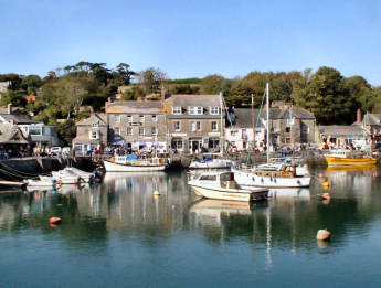 |
| By A389 from A39 just south of Wadebridge |
|
| Paul tends to be ignored by visitors, inland as it is from well known destinations such as Penzance, Newlyn and Mousehole. The first three things that strike you are the uncovered lych gate, the Cornish Cross head to the left of it and the memorial to Dolly Pentreath of Mousehole who died in 1777 and was believed to be the last person to speak Cornish as a first language. Inside there is a reasonable amount of interest. The font is unusual with octagonal base and square bowl supported by four slim pillars. The octagonal pulpit is unusual, too, entirely of carved stone and supported on slim stone pillars. Box pews are unexpected though disappointingly there are no carved bench ends. However the lectern is quite striking with its carved wood and angel finials. The screen between chancel and aisle is unusual, its centrepiece depicting the 1595 Spanish raid on Penzance, Mousehole and Paul. There is an elaborate memorial to Captain Stephen Hutchens and another to Lieutenant General Robyns. Opposite is a large car park, at one end of it the Kings Arms where we enjoyed coffee. A path off the car park leads to the former graveyard, now a pleasant spot with views to Mount's Bay and St. Michael's Mount. |
 |
 |
 |
|
|
|
|
 |
Pelynt - the name is said to mean "the parish of St. Non" - straddles the fairly busy B3359 to Looe. Witrh a couple of exceptions, there is little of interest to be found within the village. The first exception is the church, perched high on what may be an ancient site. Outside the churchyard, a tiny patch of green, proclaiming itself to be the "village green", bears a modern Cornish Cross, celebrating the millennium, as does a clock on the southern face of the tower. Due to its dour exterior, I had little expectation of the interior of the church. I was pleasantly surprised, thanks to the Trelawney Chapel, filled with memorials to the famous local family from Trelawne. Trelawneys had strong royal and church connections, counting a Bishop and a Governor of Jamaica among their number - as well as a Caribbean pirate. My favourite Trelawney epitaph is that to Edward Trelawney: "Here lyes an honest lawyer, wot you wat, a thing for all the world to wonder at." Also noteworthy are a Buller memorial and several more Trelawney memorials. As you enter, a striking and unusual stained glass window faces you. Nearby is a damaged Cornish Cross. At the other end of the village is the pleasant Jubilee Inn, where I enjoyed an excellent doorstep bacon sandwich. A mile or so to the south-east is Trelawne, once home to the Trelawneys. Dour looking, it is in a sad state, its grounds now occupied by a large holiday park. |
|
|
Pelynt is on the B3359 to Looe |
| SONG OF THE WESTERN MEN: Parson Stephen Hawker wrote his famoue "Song of the Western Men" about the trials and tribulations of Bishop Jonathan Trelawney. |
| The National Trust,
which owns so much of Cornwall's coastline, also owns the little hamlet
of Penberth and its fishing cove. A cluster of cottages, owned by
the Trust but leased to fishermen, surrounds the cove and small fishing
boats are drawn up on the slipway by electric winch. In the old days
they were pulled up by hand operated capstan. The Trust has restored
the capstan but it is no longer in use. The old fish cellars are
still there but superseded by a modern store built by the Trust.
Above the cove small fields, protected by hedges of willow, hawthorn and
escallonia, remind you of the daffodil fields of Scilly; at
one time the fishermen supplemented their summer living by growing daffodils,
violets and early potatoes - sadly no longer. These things may have
changed but the fishing hasn't except that the boats are now motorised.
The main catch is crab and lobster but bass and mackerel are still caught
by hand-line. It is a delightful spot and one of the most photographed
in Cornwall. Although a lane runs down from Treen village, there
is little or no parking. Park in the privately owned car park in
Treen and take a footpath for the half-mile to the cove. There is
great walking west along the cliffs to Porthcurno. Along the way
are Treen Cliffs, Treryn Dinas, an iron age cliff castle, and the famous
Logan Rock.
A short round walk from Porthcurno includes Penberth Cove. |
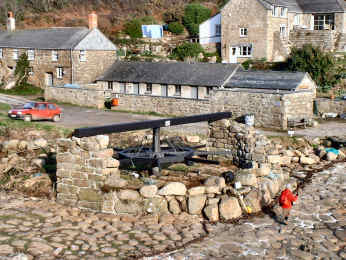 |
| Park at Treen, walk down. From Penzance A30, B3283, B3315 |
|
Pentewan, its Trailer Park and its Unexpected Industrial History
 |
Imagine my surprise,
walking through Pentewan for the first time, to discover a historic port
and more. From early times the stone quarries supplied such homes
as Antony with superb silvery grey stone. A small fishing port, at
the mouth of the St. Austell River, it came to handle cargoes of tin, stone,
sand and grain. A proper harbour was constructed in 1744 and it was the
first port to handle the local china
clay. However, when the Rashleighs built their new port at
nearby
Charlestown in 1801, Pentewan's
Hawkins family owners struggled to keep it open, eventually closing.
The harbour remains intact and still has its sea-lock but access to the
sea is blocked. Remains of industrial buildings moulder to the south
of the harbour. Substantial houses and cottages line the main street.
Walk up Pentewan Hill and follow the coast path sign to find the colonial
looking Terrace and a Georgian church. Behind the beach is a large
and orderly looking holiday trailer park. The beach, owned by the
holiday park, is private but public access is granted. The Ship Inn
is a pleasant place, with simple good value food, but gets busy from the
holiday park in summer. Two cafes in the village, one in the holiday
park. The
Pentewan Valley Trail follows the White River
A round walk from Pentewan includes woodland, Mevagissey and coast |
|
|
Off B3273 Mevagissey road from A390 at St. Austell |
| PENTEWAN UPDATE AUGUST 2011: There are plans to dredge the blocked channel to the harbour and re-open it as a fishing cove. ROWS (Revival of Working Sail) is the brainchild of local wooden boat enthusiasts Allan Proctor, Lee Moody and Paul Welch. They visualise a small fleet of boats, sailing and oared, handlining for fish such as sea bass. They hope also to establish shore based businesses such as chandler, smokehouse, boatbuilder, sailmaker and blacksmith. They have the support of Cornwall Council and the owners of the harbour, Pentewan Sands Holiday Park. I really hope it works, it would be wonderful to see Pentewan come back to real working life again. JAN 2016 - Nothing happened |
| First developed as a resort in Victorian times, first impressions suggest that Penzance is not generally very attractive. However, stray into the streets between the main shopping street and the seafront and you will discover that there are parts well worth seeking out. Chapel Street is known for its art galleries and antique shops and for its attractive Georgian homes and shops - do not miss the Egyptian House and the Admiral Benbow Inn. At the top of Chapel Street the old Market Hall is now a bank; outside stands a statue of Humphrey Davy, inventor of the miners' safety lamp. He looks down Market Jew Street, corruption of the Cornish Marghas Yow or Thursday Market. Morrab Road and the small streets at its north end are charming as is Regent Terrace and Western Promenade, part of the seafront. If you like the Newlyn School artists, you should visit Penlee House Gallery near the top of Morrab Road, a first class art gallery and small museum with regularly changing exhibitions and a fine core permanent collection; also take a look at sub-tropical Morrab Gardens nearby; ther's a Cornish Cross there. If your taste in art is more modern, try the Exchange Gallery in the former telephone exchage building. A passenger ferry operates from Penzance to the Isles of Scilly and Skybus flies from Newquay and Land's End. Sadly the helicopter service to Tresco finished at the end of October 2012. |  |
| Just off A30 10 miles before Land's End |
|
| Update 2014: Jubilee
pool, pictured here, was severely damaged in winter storms. Happily,
almost £2 million of central governmeent funding has been made available,
plus a further £1 million of local funding. It re-opened in Summer 2016.. |
| Towards
the end of September 2017 I headed down to the Roseland to pay visits to three
churches, at Philleigh, Ruan Lanihorne and Lamorran. Philleigh is an attractive small village with
an interesting church and a popular pub, the Roseland Inn, with its own brewery. The
approach to St. Filius church is attractive in summer, along an avenue of
hydrangeas to the lych gate. The church
consists just of nave, aisle and a three stage tower, the third stage short and
crenellated. Inside is a 13th century
font and striking panels carrying Charles I message to Cornwall, thanking the
Cornish for their support in the Civil War.
Where the ceiling springs from the nave arcade painted shields carry
coats of arms. Round the corner from the
church is the most attractive house in the village, the substantial slate hung The Glebe, by much-admired architect Sir
John Soane, and described by Pevsner as Georgian but looking more Queen Anne. |
 |
 |
 |
| Philleigh Church |
Church Shield |
The Glebe, Philleigh |
| It may be in Cornwall, albeit not far west of the Tamar, but its name is not Cornish but Old English, pila tun meaning "the settlement defended by stakes". Not that there is any sign of any defensive works there today. A small village, with a population of less than 500, Pillaton nevertheless can boast plenty of interest. The Weary Friar hotel claims 12th century origins as a coaching inn. It has 12 letting rooms, bar and restaurant and a fairly extensive menu. I only had coffee but found the staff very pleasant. Next to the Weary Friar is St. Odulphus Church, basically a 13th century building with three-stage tower, nave, aisle and south transept. The porch has a wagon roof with carved bosses. The interior of the church is fairly plain, notable only for the memorials in the Tillie Chapel in the transept. This is the Tillie family of Pentillie Castle which stands high above the Tamar. One wonders why Tillies should be commemorated here when there are several churches much nearer the home. I also visited Quethiock and Tideford, the latter often mispronounced as spelt but really Tiddyford for its river, the Tiddy. |
 |
 |
| Pillaton, St.Odolphs Church |
Pillaton, the Weary Friar Inn |
 |
What a contrast to
Par, just a mile away across St. Austell Bay. Par is heavily industrial,
its waterfront dominated by the vast former china clay works and its associated
harbour, and by a holiday park set immediately above the beach. Polkerris
might be another world entirely. Both are in the old parish of Tywardreath
- it means 'House on the Strand' and was the inspiration for Daphne du
Maurier's novel. Polkerris is reached down a narrow steep lane off
the road from Par to Fowey. Parking in
the village is non-existent, unless you are a resident or are lunching
in the Rashleigh Arms and are lucky enough to get a space in their small
car park. Happily there is a large car park a few hundred yards back
up the hill, a clear sign that Polkerris gets very busy in season.
I visited in March 2005, and even then the car park was fairly well used.
The village has a long fishing history, though it no longer has a fleet.
As far back as Elizabethan times, however, it could boast the largest pilchard
cellars in Cornwall, still there. Also there is the harbour wall
and quay built by the Rashleigh family, on whose estate, Menabilly, it
stood, in the 18th century. Prosperity didn't last and now Polkerris
relies on its pub, cafés and summer visitors. The Rashleigh
Inn is open all year. Sams on the Beach is recommended for its food
Round walk from Polkerris includes Gribbin Head and Readymoney Cove. |
|
|
Off A3082
St. Austell - Fowey. More images of Polkerris |
| In July 2018 we drove Mick
and Margaret, our friends and next-door neighbours to the south coast,
to Polkerris near Fowey, and enjoyed an excellent leisurely lunch at Sams on the Beach.
Sams also has a city venue at 1-2 New Bridge Street in Truro; we
hope to try it before too long. To older and creakier folks like
me Polkerris has one big disadvantage:
unless you are lunching at the Rashleigh Inn, and are able to find
space in its car park, you have a five hundred yard walk down from the
pay car park. Not too bad but, for me, much tougher on the way
back. |
 |
 |
| Sams On The Beach; good eating |
Par China Clay Works seen from Polkerris |
Return
to Towns and Villages
Return
to Home Page for Cornwall Reviews Contents
| We are not very keen
on the commercial aspects of Polperro. Streets bustling with day
visitors almost elbowing one another for room to move; shops,
restaurants and cafés all designed to part them from their money.
We prefer to approach by the coast path from Looe, avoiding the crowds
and enjoying the views from above. We love Polperro's harbour with
its small fleet of fourteen working boats, coming and going through a sea-lock
which keeps the harbour in permanent water. Around the harbour are
a museum of smuggling and fishing, a fish market, net stores, a stall selling
fresh fish and shellfish and two of the better pubs, we have enjoyed the
Blue Peter though we also like the look of the Lugger. At the landward
end of the harbour a bridge crosses the little River Pol that feeds the
harbour. Shops and homes back onto it, one of them jettied out over
the stream and known as the 'House on Props'. As there are only fourteen
working fishing boats, most fishermen's cottages are now artists studios
or holiday homes. Not a place for busy times but great in the quiet
season. There is no parking in the village itself. Instead
you park in a large car park at the head of the valley and walk
down or take the bus or horse bus.
Polperro Revisited 2016 below |
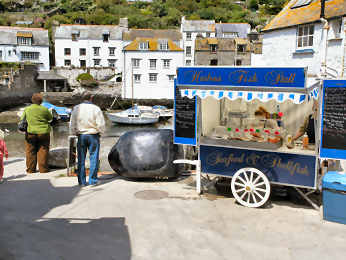 |
| By B3359 from A390 at Middle Taphouse |
|
 |
In March 2016 I decided it was high time I revisited Polperro. I was last there in 2009 and that was only a matter of passing through when nearing completion of my Cornish Coast Path project. So I was back there on a sunny day in March 2016. I would have liked to be there at high tide - it always seems to be low tide when I am there - to see the harbour in water but no luck. I shall have to go back again. One major problem with that, the extortionate cost of parking: a minimum charge of £4, a bit strong if you only want to be there for an hour or so. And for that price you have a half mile walk to the harbour. Disgracefully Polperro's web site mentions parking but fails to mention the cost. But then Polperro is generally an expensive place, probably because it has such a captive audience and takes full advantage of its luck. Many of the eating places charge more than their equivalents elsewhere and I found it a little odd that the Polperro Bakery, which had very reasonable take away prices, should charge twice as much to eat in their courtyard. I made a good choice of eating place, the Old Millhouse Inn, where a masive bacon butty and a good coffee cost me just £5. Despite my criticism, I think Polperro a lovely, if rather deliberately quaint, village. It's not a place to visit when the holiday crowds are out in force but a sunny day around high tide in spring or autumn should be ideal. Back to original Polperro entry |
|
|
From A38 at Middle Taphouse follow signs Looe then Polperro |
| Fowey on the west bank and Polruan on the east bank of the Fowey River together guard what was once a strategically important deep water harbour. Fowey and Polruan have between them a long maritime history. In medieval times they provided ships for the Crusades and for the wars with the French. Henry VIII considered them of sufficient importance to fortify them with a pair of castles and a chain across the River Fowey. Now there are yachts, fishing boats and a china clay terminal up-river and, thanks to the deep water of the Fowey River, cruise ships visit occasionally. A major regatta takes place on the river and estuary in August. There is a boat repair yard in Pulruan and, indeed, the town has a long history of boat building. Oddly, the town is part of the parish of Lantegos-by-Fowey, oddly because Polruan is a small town while Lanteglos consists of little more than church and farm. Polruan is a steep village. As you enter from the east, Fore Street descends steeply to The Quay where you will find the Lugger Inn; the Russell Inn is nearby. From The Quay a small passenger ferry crosses the Fowey River to Fowey Town. You can leave on Battery Lane, passing the massive Blockhouse, one of Henry VIII's coastal defences, paired with a similar on the Fowey side. At the top of the hill is the remains of medieval St. Saviour's Chapel and there is ample parking. Halfway down Fore Street, look to your left for remains of a granite Latin Cross, perching on top of a shaft of Pentewan stone. |
 |
 |
| Fowey and Fowey River from Polruan |
Polruan Blockhouse, china clay ship behind |
Return
to Towns and Villages
Return
to Home Page for Cornwall Reviews Contents
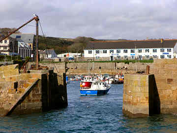 |
Porthleven is an attractive small town on Cornwall's south coast, three miles to the south-west of Helston. The long narrow harbour is a haven to both fishermen and yachtsmen. It is overlooked on its west side by an attractive pub, the Ship, and on its east side by Bay View, a long curving and very handsome row of Victorian homes, and the clock tower of the Institute, familiar from storm pictures. Since we first encountered Porthleven things have changed a great deal. We remember it as being a bit dreary and with almost no activity out of the summer holiday season. Now it seems to be full of second homes, many of them new but reasonably in character, and many of the former fisherman's cottages are now holiday rentals. Indeed, along the east side of the harbour, and up Cliff Road towards Loe Bar, restorations and new builds are almost all second homes or holiday rentals. Eating places in town have improved in response to this change and there are now many more of them. Latest addition is a fish and chip shop, opened in 2007 by a chatty incomer from Newcastle. In 2008 we enjoyed a meal from Roland's Happy Plaice, eaten sitting on the harbour wall. A pleasant short walk to the south-east takes you to remarkable Loe Bar. An attractive and enjoyable place but, like many harbour villages, this gets very busy in summer. A Rick Stein restaurant on the west side has now closed permanently. Round Walk from Helston. |
|
|
Signed by B3304 from A394 west of Helston |
| Between Caerhays and Portloe, tiny twin villages are separated by a small headland. Part of the Caerhays Estate, most of the cottages are second homes or holiday rentals. If, when you visit, Portholland looks slightly familiar, you may have seen it in the original Poldark TV series. |
 |
 |
|
|
|
 |
Jane and I were fascinated by Porthoustock when we visited a few years ago. Now I have been back I am even more taken with the place. I was there in November 2005 in the course of a walk that took in St. Keverne, Porthoustock, Porthkerris and Porthallow. While on Porthoustock beach I had a long chat with retired fisherman Roy Curnow and learned a lot about the locality. Four miles of coast here is riddled with stone quarries and it is they which have very much determined the character of Porthoustock, Porthkerris and Porthallow. Beaches have been formed by longshore drift of dark quarry spoil; that at Porthoustock rose gradually by eight feet when a massive groyne was built with a stone hopper on it to load ships. Former winch huts are now used for storage, a tractor draws boats up the beach. An earth mover maintains the height of the beach. Most cottages were once quarrymens homes; some are still lived in by descendants who make a small living from the sea but many are now second homes. There is a lovely thatched terrace just up the valley. West of England quarry still operates but St. Keverne quarry closed in 1958. Until the 1970s two cotils, small steep south facing fields were used to grow early potatoes, harvested in March or April. Porthallow, too, is now largely second home territory. Its claim to fame is as the halfway point on the South West Coath Path. |
|
|
From Helston, A3083 and B3293 to St. Keverne and follow signs |
| Jane remembers Port Isaac, from her early childhood, as a quiet remote small harbour village with little activity other than the busy fishing fleet. It is very different these days, having been discovered not only by the holiday trade but also by the second homers from the big city. It may now be far busier than she remembers but it is also, thanks to the influx of incomer money, more colourfully attractive. The old part of Port Isaac is crammed into a tight steep valley leading down to a tiny fishing harbour where crab and lobster are landed. Do not try to drive down to the harbour; you will be unable to park there. You should park in the official car park at the top of the hill and walk down, enjoying the delightful views; the narrow streets can be very difficult to negotiate in a car, even away from school vacation times. Small cottages, closely packed together, have white washed or tile hung walls. There are still fish cellars on the west side of the harbour where you can buy fresh fish and shellfish but the crab and lobster, the main catch, mostly leave the harbour and head uphill for immediate distribution. Even so, we can strongly recommend the crab. Since 2004 Port Isaac has become best known as the location for 'Doc Martin', a TV series shot in and around the village; an odd show, at first comedy, later melodrama and packed with great location shots. | 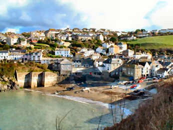 |
| Signed from B3314
from Wadebridge. Port Quin Round
Walk |
|
 |
Portloe, on the south
coast between Gorran Haven and Portscatho,
is expensive territory - inhabited largely by wealthy second home owners
- and no wonder. It is a total delight. To get the best out
of just driving through, approach from the east so the steep narrow hill
down gives you an overview of the tiny fishing cove. Leave westwards
towards
Veryan. But you will never do
Portloe justice by merely driving through. Instead, approaching from
the east, park in the only car park, way up the hill. Walk its narrow
street and enjoy the charming cottages, with a couple of exceptions no
longer fishermen's cottages. Wander down to the cove where you will
see evidence of the crab and lobster still caught by the fishermen.
The buildings on the cove are mostly part of the Lugger Hotel, one of Cornwall's
best. Get an expensive but good lunch here (they do have a car park)
or walk up the Veryan road for a pub lunch in the ancient Ship Inn.
If you are slightly adventurous, and properly shod, you can enjoy a delightful
view from the coast path in either direction. To the east, walk between
the Lugger and its car park, follow the cove, take some steps down, cross
a tiny stream and the slipway of the former Lifeboat Station ( now a home
with a view) and you will come up onto the coast path. Continue a
little way and you will come to an amazing shack that was once the Coastguard
lookout. Great views from here.
A round walk from Carne Beach includes Portloe and Veryan |
|
|
Signed from A3078 St. Mawes road, 2 miles south of Tregony |
| Port Quin is one of
those places that you would be lucky to find if you didn't know it was
there, although coast path walkers would encounter it. Tucked away
down a narrow steep lane, not far from the better known Polzeath
and Port Isaac, it is a former fishing
hamlet on a quiet cove and, except for one cottage, is all owned by the
National Trust and mostly let as holiday cottages. It must have been
a bustling little place at one time because one row of cottages was formerly
fish cellars for processing the pilchards, once Cornwall's great marine
harvest. Eat at the nearby Port Gaverne Hotel (near Port Isaac) for
the excellent local crab sandwiches. If you are walking the coast path
in these parts, beware, this section offers some of the toughest walking
you will find anywhere along the north coast, with a lot of steep climbs
- but it's well worth it for the glorious scenery. Just south along
the coast is tiny Doyden Castle, built around 1830 by Samuel Symons as
a high-life retreat and now an unusual National
Trust rental; it was used a Dwight Enys home in the original
BBC television series of Winston Graham's Poldark
books. There is a small car park down by the harbour but don't expect
to find any other facilities, thanks to the National Trust's policies.
A round walk from Port Quin to Port Isaac and back |
 |
| Signed from B3314 from Wadebridge |
|
 |
Jane remembers Portreath
from wartime when her father used to explain why the village was closed.
When we visited in 2003, I was taken by the long narrow harbour, almost
unused, and by postwar housing occupying a level V-shaped section between
harbour and cliffs. Portreath is now a very ordinary down-market
little resort, blessed by a safe sandy family beach but I wanted to find
out something of its history. It turns out that it was an 18th and
19th century port, a major player in the tin and copper trade, serving
mines around Redruth and Camborne. An important tramway ran from
Redruth and is now part of the Coast-to-Coast
Mining Trail. A steep inclined plane also ran down from the
western side. The port declined in the 20th century and the harbour
is now used by a small fishing fleet and by pleasure boats. In World
War II Portreath changed beyond recognition. The military took over,
clearing away warehouses, and the port served a top secret airfield and
weapons storage facility high on the east side at Nancekuke. The
warehousing area now has late 20th century housing on it, most of it frankly
quite unattractive, while chalets line the cliffs. The airfield remains
closed and teams still search for unspecified but apparently deadly hidden
weaponry. Below, Portreath's
Industrial History
A round walk from Portreath includes Tehidy Park and coast. |
|
|
Portreath's Industrial History |
Portreath's Industrial History
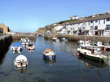 |
At a glance you would be hard put to guess at Portreath's great industrial history. Nowadays it is a combination of dormitory town for industrial Redruth and Camborne and a scruffy looking small beach and surf resort. Yet in the past it has been one of Cornwal's most important ports. The clues are there: a long well constructed double harbour, a mineral tramway trail that runs to the mine sites and on to Devoran, and the remains of an inclined plane heading steeply south from near the harbour. Construction of the harbour began in 1760 and by 1800 it was bustling with copper ore heading for South Wales and coal returning. By 1819 a tramway had been built to bring copper ore from the mines around Poldice and St. Day. In 1836 the Portreath Branchline was built, linking to the important Hayle Railway. By now ships were being built here, too, and fishing was also important. The 20th century saw gradual decline. Tin streaming ceased when the Red River was diverted in 1933. After WWII the harbour lost its industrial trade and the railway closed. The harbour became home to just a small fleet of crabbers and to pleasure boats. The busy industrial area by the harbour was developed for housing. Few clear signs remain of Portreath's former importance except on the north side of the harbour and in the remains of the Branchline's inclined plane. |
|
|
Portreath Branchline Trail and the inclined plane |
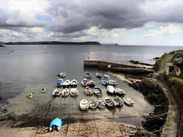 |
I have a special affection
for Portscatho because that's where Jane lived for many years. She
still has good friends there are likes to visit from time to time, often
for charity coffee mornings. When she went in late July 2007 I went
with her and wandered around taking photographs - what else? I was
particularly pleased with the somewhat atmospheric one on the left, of
the harbour with a distant view of Nare Head and the Dodman. Portscatho
is really two villages that have become joined as thay have expanded.
Down by the water and along the cliff is Portscatho. Above, originally
straggling along the road to St. Anthony Head, is Gerrans, where the church
and the Victory pub are. There is still a garage there but the shop
and tearooms are gone. Activity has largely migrated down the hill
to Portscatho where, partly supported by second and holiday homes, are
the Plume pub, a general stores, a couple of art galleries (representing
the small colony) and a tea shop. Portscatho harbour remains intact
but I doubt if there is any commercial fishing; instead small
leisure boats fill the little harbour. Despite visitors there is
a strong sense of community and gardens are opened for charity on a day
in summer. There is some good walking. A path leads down to
Polingey creek and the Percuil river. The coast path to Portloe is
of moderate grade; to St. Anthony Head is easy.
A round walk from Porth Farm includes Percuil, Gerrans and Portscatho |
|
|
Signed from A3078 St. Mawes road |
| Poughill -pronounced Puffle, is tucked away on a quite lane, leading to Northcott Mouth, on the north side of Bude. It is a steep village and the lane is narrow but, fortunately, there is a good sized car park below the church. There are some attractive cottages, particularly Church Cottage and St. Olaf's Cottage. St. Olaf's Church, dedicated to the Nowwegian King and Martyr, stands on a knoll, perhaps suggestive of an ancient site. The (unused) oak tower door has an impressive surround. The porch, in it a slate memorial in Latin, has an ancient studded oak door. Inside, wagon roofs have carved bosses. The frescoes of St. Christopher are a remarkable survival; whitewahed at the Reformation, they were rediscovered in 1894. The elaborately carved pulpit is unusual for its open fretwork. A wall plaque commemorates Sir Goldsworthy Gurney, Wadebridge doctor, builder of Bude Castle, inventor of a fast steam road carriage, whose limelight lighted the houses of Parliament for 60 years. As at Kilkhampton, there is a fine collection of early bench ends. The attractive looking Preston Gate Inn, which also calls itself a café, is open 11 to 11 every day and does interesting sounding food lunchtime and evening. Produce is mostly local and there are fish and chips on Friday, roasts on Sunday and the occasional curry evening. |  |
| From A39, N of Stratton, follow signs for Stibb abd Poughill |
|
 |
Less than half-a-mile
from the busy A39, the so-called Atlantic Highway, Poundstock is a remarkable
little hamlet. A lane loops through it from the A39 but otherwise
goes nowhere. Yet this was once an important place, mentioned in
Domesday Book but in existence as a manor for long before that. Even
if you include nearby Trekinnard and Bangors the population is tiny yet
the impressive church, set in a lovely sloping churchyard, might seem to
belong to a much larger village than this. The church as it is today
dates largely from the fifteenth century, though there are scant Norman
remains. It is dedicated to St. Winwaloe; can this really
be the same Winwaloe as on the Lizard, at Towednack and at St. Germans?
Confusingly, a nearby well is dedicated to St. Neot, as in Bodmin Moor.
There are some treasures inside: a late Norman font, an octagonal
Jacobean pulpit, a panel from the original rood screen, a 16th century
chest, parts of a wall painting, saved and exhibited against the north
wall, and some early inscribed slate tomb slabs. Sadly there are
almost no bench ends but there is an interesting bench in the chancel.
Perhaps the greatest treasure of all is at the south end of the graveyard,
a restored late medieval gildhouse (church hall), the only example in Cornwall.
In the churchyard are more early inscribed slate tomb slabs. St
Neot’s Well is off a track that heads NNW to Great Wanson. Up
the lane to Bangors is a large free car park.
Round walk Poundstock to Penfound. Round walk Penhalt Cliff via Poundstock. |
|
|
From A39 at Bangors go L, sign Poundstock, car park ¼ mile on L |
Praa Sands - Surf and Sand Resort between Helston and Penzance
| To us, who live on Cornwall's north coast, surfing automatically means Bude, Newquay's Watergate Bay and Fistral Beach, Porthtowan, Portreath and Whitesand Bay near Land's End. So, when I walked between Prussia Cove and Porthleven, it was something of a surprise to discover a good surfing beach on the south coast. The original settlement here was half-a-mile inland at Pengersick where the remnant of a great Tudor fortified manor still stands. It was the late 19th century advent of the railway in Cornwall that brought Victorian sun seekers in search of good beaches. In the 20th century a small settlement of holiday chalets grew up above the beach and a holiday park opened. The village of Praa Sands is not very prepossessing but the beach is glorious. A curving mile of soft sand stretches from Sydney Cove to Lesceave Rocks. In the summer this is part family beach holiday territory and part young surfers paradise. The beach is well served by lifeguards and divided between surfers, bodyboarders and swimmers. There is a surf shop in the village and a small surf school trains youngsters. There is ample parking and just above the beach is Beachcombers beach café, a decent pub and a restaurant. |
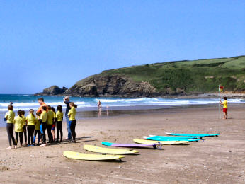 |
| Signed down lane off A394 halfway tween Helston and Penzance |
|
 |
What sticks most strongly
in my mind, and upsets me most, about Probus, is the destruction of the
wonderful Demonstration Garden
that stood at the east end of the village. Trelawney Garden Centre
of Wadebridge bought the site, complete with garden, with promises to open
a garden centre, keeping and improving the Demonstration Garden.
In 2014 they repeated their promise and said the work was just about to
start. Now, in July 2020 there has been little action on the site.
What is due to happen is unclear. I just hope that, in addition to
a new garden centre, they will keep their promise about the garden.
At present, the site is a wreck.
Now to Probus village. An odd place: a population of around 2000 but little sign of life when I have been there. There is a pub, the Hawkins Arms, a restaurant, the Village Bar and Grill, a Fish and Chip shop, an antique centre in a disused Chapel, and a Farm Shop. The village manages to be relatively unattractive but do note the delightful pictorial bus stop and a nice 1897 Golden Jubilee lamp on Fore Street. The church, nave, two aisles and impressive 'Somerset' tower, has a fine screen, good pulpit and font and a nice carved pew, but sadly has no carved bench ends. Best feature of the church is the colourful chancel ceiling . Outside the east end of the church is an impressive Hawkins tomb, in need of repair. |
|
|
A390 St. Austell - Truro at roundabout by Trewithen garden |
| This does seem to be an oddly named village, but less oddly when you understand that it is a variation on "coit" and therefore means wood or woodland, not that there is much woodland here these days. According to Genuki, the name was originally Gwydhek and, in its present form, is pronounced "Gwithick". I was there, in mid-September 2017, essentially to see the Cornish Cross, a tall wheel-headed cross in three sections, probably medieval rather than earlier. In the event I was pleasantly surprised by the church interior which retains some early features. Behind the altar is an elaborate and colourful reredos. The nave and aisle ceilings are wagon roofed with carved bosses; the chancel ceiling is wonderfully patterned and coloured. Most unusually the rood stairs are still in place, though the loft and screen are long gone. In the chapel in the south transept a number of brasses are displayed, the oldest, to Roger Kyngdon, of 1471. Another brass is to Johann Rooke Fletcher. The quire pew has an elaborately carved back, scenes including the crucifixion. I also visited Pillaton and Tideford, the latter often mispronounced as spelt but really Tiddyford for its river, the Tiddy. |
 |

|  |
| Quethiock Cornish Cross |
Quethiock Church | Quethiock Chancel Ceiling |
Return
to Towns and Villages
Return
to Home Page for Cornwall Reviews Contents
 |
What a change since I first knew Redruth. I remember it from the 1950s when heavy holiday traffic clogged the main streets and the whole place had an air of poverty and deprivation. Unsurprising since the town's one-time wealth was based on copper and tin mining. The collapse of the mining industry might have spelled the death knell for Redruth but, when I took time to walk around in June 2008, after a walk on the Redruth and Chacewater Trail, I was amazed at how attractive a town it now is. Thankfully, the main east-west street, Fore Street, is now pedestrianised; along it are a famous clock tower and sculptures of a miner and of dogs made of boots. Alma Place has the Victorian buildings - the old Miners Exchange and Coffee Tavern and the Cornwall Centre, home to the Tregellas Tapestries, beneath it Market Way and the Buttermarket. Cross Street nearby is the location of Murdoch House, once home to Richard Murdoch, who lighted his home with the world's first gas light and built a steam locomotive before Richard Trevithick. There are handsome homes on West End and in Coach Lane off it. The mother church, oddly, is almost a mile away at Churchtown, in the shadow of Carn Brea. A new weekly Farmer's Market operates on Fridays under the clock tower on Fore Street. Also on Fore Street look out for the striking art deco Regal cinema. |
|
|
Signed from A30. Car Parking is mostly to north of Fore Street |
| TIC in Kresenn Kernow, the Cornwall Centre, Alma Place, has good town guide and 2 informative trail leaflets |
| Oddly for Cornwall, the name Roche, pronounced Roach, is neither Cornish nor English but is from the Norman French La Roche, meaning The Rock: the reason why, to anyone looking at the central photograph below of Roche Rock, will be obvious. The Cornish name was Tregarrek, meaning "Farm or hamlet by the rock". It is a large village with a population of around 4000 and it has many of the facilities which go with that: a couple of pubs, a post office, a primary school, a fish and chip shop, kebabs. The church is of little interest, except for a fine carved 12th century Pentewan stone font and a tall Cornish Cross in the graveyard. Just a mile or so away, just off the main A30, is Cornwall Services, a major highway service areas with petrol stations. In a vast modern building are several food outlets, including Rowe's Bakery, pizza, Macdonalds, Costa Coffee, burgers and hot dogs. There are also a Saltrock clothing shop, a climbing wall, and a children's 'soft play' area. |
 |
 |
 |
|
|
|
|
| If Newquay is Cornwall's down-market playground, the Camel Estuary is its distinctly up-market counterpart. This is where the seriously rich gather - the permanent rich all year, the vacationing rich in the season. Come here in the summer and you might be in 'Kensington-on-Sea', an impression especially strong a few years ago when the royal princes regularly holidayed with their friends in Rock. The main activity is sailing and the estuary is often crowded with small boats. Highlight is when the Cornish Crabbers or the small brown-sailed Drascombe Luggers (working-boat look-alikes) are out. Windsurfers congregate downstream at Daymer Bay - though not in summer as it's a family beach then - surfers downstream again at Polzeath. Social life centres around the sailing club, St. Enodoc Hotel and - for the drinkers - the Mariners and the Rock Inn down by the water. Golfers enjoy St. Enodoc Golf Club, one of Cornwall's best - and most expensive! During the day coast path walkers cross the water here, by ferry to and from Padstow. In the evening the foodies cross to Padstow for Rick Stein's famed Seafood Restaurant and several other top spots. One of our favourite short walks takes us from Polzeath via Daymer and across the springy turf to Rock; a short, and legal, golf course detour takes in St. Enodoc church and the nearby Jesus Well. See also Porthilly on my Churches page. | 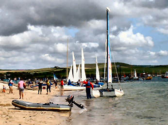 |
|
|
| Towards the end of September 2017 I headed down to the Roseland to pay visits to three churches, at Philleigh, Ruan Lanihorne and Lamorran. My memories of Ruan Lanihorne [not to be confused with Ruan High Lanes on the St. Mawes road, or with the many Ruans on the Lizard] are of an early meeting there with Jane and of lunching there with her at the attractive and excellent King's Head. On this occasion I just had a coffee in the King's Head before taking a look at the church. Almost opposite, and a bit below, is St. Rumon's church, mostly 14th century, with a tower of the late 17th century. Pevsner suggests that the font is 14th century, its cover made of wall plates of a previous roof. The pulpit is made of old bench ends and dates from around 1530. A monument of a praying priest is 13th century. Two wall-mounted boards carry the Ten Commandments. Where the ceiling springs from the nave wall there are several painted shields, one noting the restoration of 1866, others with unfamiliar (to me) coats of arms. When I was there a tapestry was on display, depicting "Historical Ruan". |
 |
 |
 |
| Church Tower |
Luke Vault in the churchyard |
Coat of Arms Shield |
Ruan Minor, Ruan Major and St. Ruan
| Here is an odd collection of small villages, all within a few miles of one another on the Lizard. You would expect Ruan Major, named for St. Rumon, to be the most substantial of the three. Instead it almost doesn't exist at all. All you will find there are a couple of farms, a graveyard and the deserted St. Rumon's church, standing amongst trees. Some of the rood screen is still in place, simple carving on it including mason's tools. To the south west of Ruan Major is St. Ruan, a small village with no church but with St. Ruan's holy well nearby and an "incised stone" in the grounds of Westie Way. The largest settlement, just to the north-east of St. Ruan, is Ruan Minor. This is the one with the church, not one of any great significance. St. Ruan's church is of little interest. It's single stage crenellated tower is stubby. The nave is commensurately low. A Norman font carries a simple zig-zag motif. Outside, by the porch is another font, used as a flower pot. |
 |
 |
 |
| The font flowerpot |
Ruan Minor Church Tower |
The modern cross |
| Saltash
stands across the broad River Tamar from Plymouth. Two great bridges cross the river:
Isambard Kingdom Brunel's great rail bridge of 1859, a remarkable feat
of engineering, and the impressive road bridge of 1962. A foot and cycle path runs alongside the main
carriageway, so you can walk or ride across to the Plymouth side. Saltash itself is one of Cornwall's larger
towns with a population of around 16,000 at the last census in 2011. It has a long history, being recognised as a
borough by 1201, but has suffered in the 20th and 21st centuries. Still a thriving town and fishing port well
into the 20th century, it was badly hit by bombing in the 2nd World War and
has been in some degree of decline ever since.
Thanks in part to the construction of the road bridge, and a tunnel
leading to it, much old housing had to be demolished. What was picturesque housing along the
waterfront is long gone, as is the former fishing fleet. The only touch of interest on the waterfront
is the Union Inn, its colourful murals by local photographer and artist Mick
Lobb, and statues of Brunel and Ann Glanville. Now that the waterfront has lost
its former significance it is up the hill in the main part of the town that the
worthwhile buildings are to be found. I
parked in a reasonably priced car park off Albert Road and found that I had
picked the ideal spot. Just to my left
was a small memorial 'Peace Park' with interesting memorial seats (and even a
memorial WWI litter bin) by David Ogilvie, whose work can be found all over the
country. I sat there for a while and
realised I had really picked the ideal spot.
Directly ahead of me was a war memorial with elaborate gates with two
illustrative plaques, to its left the Church of St. Nicholas and St. Faith,
to the left again the attractive Guildhall. The
Guildhall stands on the corner of Fore Street which leads to pedestrian access
to the Tamar Road Bridge and on down to the waterfront. Disappointingly I had managed to pick the wrong day -
Saturday- and not only was the church closed but so was the Guildhall. i was later able to visit both; the Guildhall is open on
weekdays, the church occasionally. I walked a
little way down Fore Street and found the entrance to the pedestrian walkway
along the road bridge. At its entrance I
was looking across to the lovely "Cornish Cross" that Jane and I had
made an expedition to see when it was first erected in 2013. This time, it glinted colourfully in the
strong sun. Below the bridge, in a grassy area, there is a plaque by Thrussell and Thrussell. As for the church, its late Victorian period
may well reduce its interest to visitors;
if so, you should definitely visit Saltash's mother church, St. Stephens, about a mile
from the centre on St. Stephens Road, which leaves Callington Road where it
becomes Fore Street at Victoria Gardens. Saltash Waterfront |
 |
 |
 |
| Saltash's Attractive Guildhall |
Tamar Cross |
David Ogilvie Saltash Peace Garden Seat |
Return
to Towns and Villages
Return
to Home Page for Cornwall Reviews Contents
| At the very end October 2018 I revisited Saltash, partly in the hope of seeing inside St. Nicholas and St. Faith (I was successful) and partly to visit the waterfront on the broad River Tamar. As Pevsner points out the waterfront is not what it was; now there is no fishing fleet, no commercial activity except a couple of pubs and a cafe. One of the pubs, the Union Inn, is colourfully decorated with a Union Flag on its front and a mural on one side. Head a little upstream and you get a fine view of the undersides of the two great bridges. Back a little downstream and you find a statue of Isambard Kingdom Brunel, admiring his great rail bridge of 1859. Nearby the figure of Ann Glanville sits on a bench: she lived from 1796 to 1880 and became a celebrity for her achievements as a gig rower. Quite unexpected here is a reproduction of a Turner painting of old Saltash waterfront, but why on earth is the artist not credited? Also unexpected is a pub, the Ashtorre Rock Inn, almost directly beneath Brunel's rail bridge. Nearby, in front of the Just Be Cafe and wine bar, is a large impressionistic sculpture of a boat and oars. |
 |
 |
 |
| Brunel admires his bridge |
The Union Inn on Saltash Waterfront |
Ann Glanville, champion rower |
Return
to Towns and Villages
Return
to Home Page for Cornwall Reviews Contents
| I
have been in Sancreed, way down west in West Penwith, almost to Land's End, on
three occasions. The first was in July
2006, the second in March 2008 then, after a gap of more than nine years, I was
back there in October 2017. In 2006, in
search only of antiquities, I had ignored the village and had been to Sancreed
Beacon and Caer Bran. In 2008 I had
concentrated on the church itself and he nearby Holy Well and Baptistry
Chapel. This time, in October 2017, the
church was closed for renovation so I again concentrated on the Cornish Crosses,
one of the finest church collections in Cornwall: I counted five in all, including one on the
graveyard hedge to the road and one on the wall by the main steps. I hope to revisit when the church restoration
is complete in, probably early in 2018.
In the meantime, some information gleaned from Pevsner. Saint Sancredus church is largely of the 15th
century and consists of nave, north transept and short pinnacled tower. The porch has an original wagon roof. Inside are remains of a rood screen with
amusing carvings and a 15th century font.
Some notable artists are buried in the churchyard, including Stanhope
Alexander Forbes, Elizabeth Adela Forbes and Thomas Cooper Gotch. Nearby, a holy well and baptistry are marked
by a modern Cornish Cross. 2019 - restoration complete, see item on my holy sites page. |
 |
 |
| Sancreed Church |
One of the Cornish Crosses |
Return
to Towns and Villages
Return
to Home Page for Cornwall Reviews Contents
 |
It is amazing what
tourism, second homers, coast path walkers and surfers have done for some
Cornish towns and villages - St. Agnes more than most. When Jane
first knew it in the 1960s, St. Agnes was a dull, run-down former mining
village. Now it is considerably revitalised, bright and colourful.
Shops seem to flourish - local stores as well as art and craft galleries.
The beach at Trevaunance Cove attracts families and surfers. Chapel
Porth has one of the great beach cafés, with a simple but unusual
menu - and their renowned hedgehog ice cream. Walking is good here,
too. The coast path from St. Agnes to Chapel Porth is one of the
most gloriously scenic sections with high cliffs and ruined mine engine
houses; highlight is Towanroath engine house, part of Wheal
Coates mine. Views from the path and from 629 foot St. Agnes
Beacon stretch from St. Ives
to Trevose Head by Padstow. And, if you want to walk
up a steep hill, try Stippy Stappy, picured on the left. Tin workings
at Blue Hills Sett, above Trevellas Porth, have been restored. Once
tin was streamed in this valley; the mine closed in 1897 but
the Wills family have continued tin streaming. A short tour of the
works demonstrates processes - panning, vanning and jigging! At the
top of town a village museum covers 'Tin Mining, Turtles, Fishing, Folklore'. More St. Agnes |
|
|
B34277 from A30 at Chiverton Cross roundabout |
| I revisited St. Agnes at the end of December 2016, primarily to photograph the Cornish Cross in the churchyard. First, however, I parked down at Trevaunance Cove where I chatted to the stonemason, he with high-vis jacket and tricolour collie in the photo below right. I then drove back up to St. Agnes village and parked in the donation car park near the museum. I walked through the village and down Stippy Stappy, the steep street of Georgian cottages. That made it quite a steep climb back up into the village. When I reached the church, I got my photo of the Cornish Cross but was, as so often, disapppointed to find the church bolted and barred. In principl;e, I can understand remote rural churches being closed by why on earth should the Diocese of Truro allow a church in the middle of a busy village to be closed in the middle of the day. Very unfriendly and, to my mind, most un-Christian! |
 |
 |
|
|
|
| I visited St. Cleer in early October 2016, primarily to look inside the church which I had not done previously. My only previous visits to St. Cleer had been when doing one of Mark Camp's Bodmin Moor round walks, this walk from Minions including Trethevy Quoit, King Doniert's Stone and the Minons Longstone. St. Cleer is a couple miles due north of Liskeard and about the same distance south-south west of Minions. One of Cornwall's finest portal dolmens, Trethevy Quoit, is about 1 mile to the north-east. While the church is the most noticeable feature of the village, the well house, north-east of the church, down Well Lane, is notable. The pretty building is 15th century; alongside it stands a much earlier Cornish Cross. St. Clarus church, at the top of the hill, is mostly 15th century, restored in the 19th. By the porch is a small Cornish Cross; inside the porch is a carved roof boss and, of all things an old plough. Inside the church are barrel vaulted ceilings, a screen complete with rood, colourful altars, some good stained glass, including one modern window, and a "millennium map" of the parish. The font is 13th century. A 1614 slate monument is to Robert Langeford. Verses from the bible adorn the walls. There are two pubs in the village, the Stag and the Market Inn. Behind the church is a fair sized free car park and toilets. |
 |
| At junction of minor roads, halfway tween Liskeard and Minions |
|
 |
Less than two miles
from the heart of Truro, St. Clement
might be another world entirely. Reached by a quiet and narrow lane,
it nestles above the tidal Tresillian
River, its wooded banks a haunt of herons. Jane and I revisited
after more than thirty years and, for the first time, took a close look
at the church. The delightful churchyard is entered through an unusual
lych gate, rooms above it and a filled-in coffen stile, like a great granite
cattle grid, beneath your feet. The churchyard, itself part of a
wildlife project, is full of ancient tomb stones with sentimental inscriptions.
Near the south porch is a remarkable survival, an eleven foot high granite
pillar, twice used as a 6th century memorial, re-cut as a Celtic Cross
and later used as a gate-post. Inside is a pulpit of green serpentine,
a 14th century font and a rather touching marble memorial to Samuel Thomas.
An easy one mile, sometimes muddy, walk down-river brings you to the village
of Malpas and its enjoyable Heron Inn. A pleasant, but sometimes muddy, walk
up-river brings you to Tresillian village just east of Truro. A walk
uphill and across fields brings you to Boscawen Park on the Truro River
just on the south side of Truro city centre. There is a small amount
of parking at the creek below the church.
A round walk includes St. Clement and Malpas. |
|
|
Signed L from Trafalgar roundabout Truro |
| I
was first in St. Clether in May 2007 when I did a round walk that started near
St. Clether and included Tregulland, Basill, Treraven Farm, Trecollas Farm and Chapel,
Polgray and the valley of the River Inny.
On that occasion I sought out a couple of Cornish Crosses, one on the
right in a hedge on the lane uphill towards Basill Farm, the other in a field
below a leat that once fed a water mill in Basill. I took a look at Basill Manor (not open to
the general public) which is home to the Peredur Trust which trains and supports
youngsters with autism and learning disabilities. Opposite
is a leat which, walked carefully, allows a view of a Cornisjh Cross. St. Clederus church is up the hill to the
north, opposite the former Vicarage, an attractive house. Close to the church entrance (wheelchair
friendly) is the Sunday School; I am
unsure whether this still operates. If
you take a path through the churchyard, leaving by an iron gate, you will come
eventually, after about 500 yards of rough moorland, to a gate into an
enclosure. Here is St. Clederus Chapel
and Holy Well. The well house is
separate from the chapel. The chapel is
of rough stone; inside is a simple
granite altar. Do not miss the 1913 notice
asking for 3d (three old pence) towards the upkeep of the chapel. For that matter, don't miss the notice
on the outer screen door, referring to the wire mesh as "mash." |
 |
 |
| St. Clether Church & Sunday School |
St. Clederus Chapel |
Return
to Towns and Villages
Return
to Home Page for Cornwall Reviews Contents
 |
You may wonder why
so short a write-up for St. Columb. Well, there's not much to say.
It's a long thin town with residential sprawl at one end, industrial at
the other. The main street is so narrow that stage coaches must have
had great difficulty getting through - and today's buses avoid the challenge.
Shops are drab and uninteresting and, except in a couple of side streets,
there are few attractive buildings. The old toll house, at the southern
end, cries out for restoration. All I could find to enjoy, apart
from the church which I found locked, were the two things pictured here.
The above was written in late 2006. I revisited in August 2016 during an outing that also included St.Columb Minor and Colan. In St. Columb Major, as in the others, I was primarily interested in visiting the church which dominates the northern end of the town. Unusually its two lych gate entrances are both on the church's eastern side. For a full report on St. Columba's church, go to my Churches page. For a walk to St.Mawgan and Mawgan Porth set off on Victoria Road, just south of the church. This becomes Halveor Lane, at the end of which a footpath continues in woods to St. Mawgan., from where you can continue to Mawgan Porth. |
 |
|
|
|
|
| My early August expedition to the St. Columb area took me first to the hamlet of Colan then, after stops at Porth Reservoir and Melangoose Mill, on my way to St. Columb Major, I decided to go next to St. Columb Minor. Disappointingly, despite a notice in the porch saying that Colan church was open, it was firmly locked. There was no-one in the nearby houses who I could ask for a key. I shall return on another occasion and hope that then Colan church will be open. St. Columb Minor is very close by so I carried on to it. The church stands on a prominent mound, probably a pre-Christian site and overlooks the Farmers Arms - perhaps an opportunity for thirsting after righteousness. I didn't have the time to try the pub but have a look at its web site; there are several good bargains to be had. The church is approached by either of two flights of steps, one of them quite steep. It has nave and two aisles and a tall four stage pinnacled tower. The interior of the porch is striking with its Gothic door and door arch. Inside is not very impressive, sadly there are no ancient bench ends, but a nice pulpit has linenfold panelling and there is an attractive tall carved lectern. There is also a nice modern stained glass window, commemorating Bill and Betty Rodgers. |  |
| Signed off A3059, Trekenning Roundabout (A39), to Newquay |
|
 |
St. Day is in the Mining Villages Regeneration Project, part of the Mining World Heritage Project; others are Carharrack, Stithians, Lanner and Gwennap. There are trail leaflets for each village and its surrounds. Best is for St. Day, by far the most interesting of the villages. The name St. Day was acquired when the Breton saint of that name, later Bishop of Nevers, founded a monastic cell here in the late 7th century. In medieval times it was a stopping point on the pilgrimage to St. Michael's Mount. In the 19th century it, along with the surrounding Gwennap area, was a major producer of copper. The mines are gone but the evidence of them is everywhere around. There are two published trails for St. Day. The Village Trail includes the ruined church, the narrow-mullioned Manor Workshop, the handsome Clock Tower and the attractive Old Post Office. Don't miss the old market square, and its attractive new Mills Terrace, or Mills Street, charity housing founded by local success William John Mills. The Outer Trail includes two shutes (springs), the Parish Pound, a boundary stone, Gwennap Pit and, if the owners of Menheer Farm are in, a Roman milestone. I like St. Day which is on the Land's End Trail. My one disappointment about the village is that, when passing through at lunchtime, the pleasant St. Day Inn only seems to be open at weekends. |
|
|
Signed just off A30 at Scorrier |
| I was last at the church in St. Dennis in July 2008, having walked up on a path due south from Goss Moor. This time, in December 2016, I drove up to the church, high up a hill north of the village. My interest was the site itself, the church standing within an iron-age hill-fort, and in the Cornish Cross standing in what may be its original base close to the porch. On the other side of the porch, oddly, there is an old font, simply removed from the church when replaced and just dumped outside. Sadly, as so often, I was unable to gain access to the church though, since it was rebuilt in 1847, it is unlikely that mch original survives inside. A population of around 3,000 has St. Dennis hovering between village and town status. There is doubt as to whether the village, taking its name from the earlier church, is named for the early Italian Bishop Dionysius or whether it is a corruption of Dinas, the Cornish word for a hill-fort, the church standing within one, high above the village. In the 1940s, when the china clay industry was booming, St. Dennis boasted a War Memorial Club, Band Club, Football Club and the Plaza Cinema. In the 1960's it had a Co-op store, three mens hairdressers, a ladies hairdresser, four petrol filling stations and car repair workshops, two schools, two doctors surgeries, a chemist shop, fire station, blacksmith shop, coalyard, two pubs, cobblers shop, two fish and chip shops, two bakeries, two chapels, post office, undertaker, launderette and a furniture showroom.. With the contraction and mechanisation of the china clay industry, some of these businesses suffered and closed but St. Dennis remains an active community with a noteworthy town band.. |
 |
 |
 |
|
|
|
|
| I visited St. Ewe, not far from the famed Heligan Garden, at the end of December 2016. My first purpose was to photograph a Cornish Cross on the road to Gorran Churchtown. This I found easily, complete with a handy layby and an easily opened field gate. The cross itself, known as Beacon Cross, was somewhat obscured by hedge growth but I was able to get an acceptable photo. I then parked in St. Ewe village, again no problem as there is ample church parking. It is an attractive small village, notable for three things: a church with a most unusual, for Cornwall, octagonal broach spire; the remains of what must surely be an old market cross, complete with mounting block on one side; and a first rate pub, the Crown Inn, which does a superb value fish-and-chip lunch on Fridays. The church, apart from its spire, disappoints somewhat, the ancient bench ends having been destroyed by the Victorians. However, there is a good Norman font and fine woodwork in the carved pulpit and elaborate screen. There are good memorials to William Williams and William Mohun. |
 |
 |
 |
|
|
|
|
|
I
was last in St. Gennys way back in 2009, when I was walking the complete
Cornish Coast Path from the Devon border in the north at Welcombe Mouth to the
Tamar ferry crossing at Cremyl opposite Plymouth. At that time I didn't pay any attention to St. Gennys as I was keen to get on into Crackington Haven. This time, in mid June 2018, I
had a churches day, revisiting Lesnewth and St. Juliot and looking inside St.
Gennys for the first time. St. Gennys is
just to the north of Crackington Haven but where the latter usually bustles, St.
Gennys is a tranquil spot an consists only of the church, Churchtown Farm,
Churchtown Cottages, and the former School House, now holiday apartments. If you follow the National Trust sign to the
Coast Path you soon come to Pencannow Point, from whose high and vertical cliff
there are fine views to Crackington Haven below and on to towering Cambeak
Point with its folded rock strata. St. Gennys Church is tucked away in a small valley, its neighbour the old School
House. A filled-in coffen stile leads
through a wrought iron gate next to a post box and in to the churchyard. Immediately ahead of you is what may have
been the base of a Cornish Cross. The
earliest part of the church, the lower two stages of the tower, and the walls
of the chancel, are from Norman times;
the tower is topped by striking crocketed pinnacles. Notable features inside include a fairly
crude 12th century font, a fine altar cloth, slate wall memorials, an
interesting, possibly medieval, chest, a simple pulpit on a stone base, remains
of altar rails and some 20th century stained glass. |
 |
 |
 |
| Church Tower |
The Old School House |
Churchtown Cottages |
Return
to Towns and Villages
Return
to Home Page for Cornwall Reviews Contents
 |
Tucked away, just off the main Liskeard to Plymouth road, on the tidal River Lynher - but with relatively little obvious access to the water - is the straggling village of St. Germans, once the estate village to Port Eliot house, stately home of the Earls of St. Germans. As you enter the village, you pass charming Tudor Moyles Almshouses with ambulatories on both floors but the real surprise is the church at the far end of the village. A cathedral in Saxon times, then an Augustinian priory under the Normans, its domestic buildings are now the heart of Port Eliot house. The church has two west towers, one square, one octagonal, and a superb Norman west door. Inside is glass by William Morris and Burne Jones and a grossly 'over-the-top' Eliot memorial by sculptor Rysbrack. Port Eliot house holds a literary festival in summer, proving to be more successful each passing summer. Until 2008 the house was not open to the public but, as a result of an inheritance tax gift in lieu, it is now open from March to mid-June. In addition to the house, with its John Soane rooms, its fine furniture and collection of Joshua Reynolds portraits, you can wander freely in 600 acres of gardens and grounds. The Eliot Arms pub looks attractive and claims fine food but, when we visited the house in March 2008, we had already eaten at the disappointing Crooked Spaniards at Cargreen. |
|
|
By B3249 off A38 near Tideford. St. Germans revisited 2016 |
| When we visited St. Germans in 2008 it was only to look around Port Eliot House and Garden, a visit we enjoyed, especially for the superb Soane's Room, decorated by the remarkable late Robert Lenkiewicz. Next time I was there was June 2016 when I wen to look around the rest of the village. I explored four separate parts of the village, which straggles roughly parallel to the main railway line from London Paddington to Penzance, mostly on its north side but with a western extremity on its south side. There are two routes down to the river. First I took Quay Road that leads down to the River Tiddy. Here are the Sailing Club, some attractive cottages, lime kilns and an impressive view of the railway viaduct. I then took Old Quay Lane, leading down to the other side of the viaduct. On the way down I passed an almost hidden well and a stile to nowhere. At the bottom was Battery Cottage, an impressive collection of cannon in its garden. Back up in the village, I spent some time in the church, vast but disappointing, then headed for the west end of town. Here are the unusual but quite striking Moyle's Almshouses, pictured right, Memorial Cottage, commemorating the 6th Earl of St. Germans, clearly a man of many parts, and the Eliot Arms, a pleasant pub with bar snacks at lunchtime and a full restaurant menu in the evening. |  |
| Back to St. Germans |
|
 |
I visited St.Issey church on a warm and sunny July Saturday, a day when I also managed to visit the churches at St. Merryn and St. Ervan and the remarkable garden of self-proclaimed bard, Ed Prynn, who has erected Prynnhenge in the small garden of his bungalow not far from St. Issey. St. Issey is a fairly large village by Cornish standards with a population of around 1000. Its name, a reference to St. Isa or Idi, one of the many evangelising daughters of Welsh King Brychan, was originally Egloscrug, the church on the barrow. Behind the church, the attractive school building has a camel weathervane. Opposite the church is the Ring o'Bells Inn. When I was in St. Issey in July 2016 I was delighted to spot a short parade of steam powered vehicles on their way to the Padstow Festival. St, Issey church was largely rebult in 1891; happily, many good internal features were retained. The aisle arches are unusual, coourfully inscribed with biblical sayings. The font carries lightly carved decoration. The fine reredos is 14th century and of the local blue Cataclews stone; Pevsner surrests that it was originally part of a tomb chest. The Ring O'Bells dates from the 17th century and retains original features. The owner has a smallholding nearby, where he rears livestock and grows produce to serve in his restaurant. |
|
|
On busy A389 Wadebridge - Padstow. Church car park. |
| Cornwall's best known harbour town is on the north coast of West Penwith, just a dozen miles from Land's End. On its north side is Porthmeor, the surfers beach, above it a good beach café and the Tate Gallery. Porthminster is on its south side with a bathing beach of golden sand and a rather classy beach café. Between is The Island, topped by St. Nicholas Chapel and with Porthgwidden beach below, the tidal fishing and boating harbour. The pier that encloses the harbour was built by John Smeaton in 1767–70; at its end stands a small lighthouse. Behind the beaches and harbour are steep narrow streets crammed with tiny picturesque cottages and loads of art and craft studios, galleries and shops. Above P:orthmeor beach stands the Tate Modern art gallery. The artistic connection continues with a Barbara Hepworth Sculpture Garden and galleries with changing exhibitions in the former Mariners Church. Near the latter is the Sloop Craft Market. Towards the edge of town, the former Bernard Leach Pottery is now both Pottery and Musem. The harbour front is full of cafes and restaurants - and carry-out Cornish pasty shops and cream teas. St. Ives may be very touristy but we enjoy its artistic connections - and just wandering. Parking can be difficult and expensive but, if you arrive early, the car park by the station is quite convenient. |
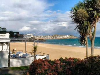 |
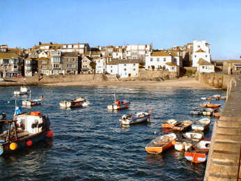 |
|
|
|
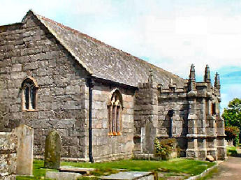 |
When tin mining prospered
here in the 19th century, its population was over 5000. Then St.
Just in Penwith would have been very workaday, its character dictated by
the toughness of its workers' occupation. It is more attractive now but,
despite recent regeneration, population is only around 4000. Now
that visitors come to see the relics of industry, to enjoy Cape Cornwall
and find respite from the rigours of the Cornish Coast Path, St. Just has
acquired a couple of teashops and several art galleries and craft shops
yet still retains its local shops, butchers, baker etc, and several pubs;
homes look well cared for. St. Justus church
is handsome from outside, thanks to its tower and elaborate porch, and
is full of interest inside. Behind Bank Square, in the centre of the
town, a circular embanked enclosure is described as a 'plen a gwary' or
'playing place' where the Cornish Ordinalia was performed in medieval times;
however, it is just as likely that its origin was as an iron age settlement
enclosure, a typical bank with encircling ditch. There are several
pubs and a pasty shop in the square. There is a moderate amount of
car parking, including some spaces in the square.
Not to be confused with St. Just in Roseland |
|
|
Best by B3306 coast road from St. Ives |
St. Keverne
on the Lizard Peninsula
 |
One of the most attractive
villages on the Lizard peninsula, St. Keverne is worth lingering in for
its history, its church and its
pubs. I had passed through the village on several occasions on the
way to walks but in November 2005 I parked there for a walk to Porthoustock
and Porthallow and had time to explore after. Unlike some
Cornish villages, St. Keverne still has the feeling of a real place with
a life of its own - to the extent that it can boast a Silver Band and Male
Voice Choir and Ox Roast, Carnival and Rodeo festivals. Eleven miles
from the supermarkets of Helston, it has happily managed to retain some
shops. St. Keverne's main historic claim to fame goes back to 1497.
The Cornish had expected that Welsh Henry VII, who claimed the English
throne in 1485, would treat his fellow Celts well and at first he did.
Then heavy taxes were imposed to support Henry's Scottish wars, a matter
the Cornish felt no concern of theirs. A Cornish force, led by Lord
Audley, Michael Joseph the St. Keverne blacksmith and Thomas Flamank, a
Bodmin
lawyer, marched on London to be routed by Henry's army at Blackheath.
Joseph and Flamank were cruelly executed. Their memorial is by the
lych gate, their statue up the Helston road.
Of the two pubs I particularly like the Three Tuns, where I have been made
very welcome by landlord and locals.
Round walks from Coverack and from Porthoustock include St. Keverne. |
|
|
By A3083 and B3293 from A394 at Helston |
 |
St. Kew is the 'churchtown' of an extensive but little populated parish in North Cornwall. Now of little importance, except for its excellent eponymous hostelry, in medieval times it was a centre of some importance. The names of its relatively few buildings bear witness to this former importance. The church of St. James the Great - an unusual dedication - is believed once to have been the site of a Celtic monastery and indeed is apparently mentioned as early as the 6th century. Consisting of nave, two aisles and a tall three stage tower, it is noteworthy for its three wagon roofs, its stained glass (much admired by Pevsner), its original rood stairs, its much later elaborate rood screen, its elaborately carved font. There is a handsome pulpit, remains of a lantern cross and an unusual stone carved in Latin and Ogham scripts. Outside is a tall but damaged Celtic Cross and elaborate triple bank of steps up from the road. Adjacent is the admired St. Kew Inn, itself probably originally of the 15th century; a fairly elaborate evening menu is counter-balanced by simpler lunchime snacks. Southeast of the inn is the large former vicarage. Other interesting buildings include The Barton, Barton Farm and The Grange. John Alden includes a walk from St. Kew in his iwalkcornwall but when I tried it stiles were almost impassable for mud and barbed wire. |
|
|
Signed from St. Kew Highway on A39 Wadebrisge to Camelford. |
| Reached by winding lanes from Liskeard, if you continue beyond St. Keyne you come to Duloe. There is not much to St. Keyne, on whose south-east side is the church of St. Kayna. It stands on a mound, raised well above the road, suggesting, as so often in Cornwall, a pre-Christian site. Opposite the church is the "Little Old School House", originally, to judge by its tallet steps, a small barn of sorts. South-east of the church is St. Keyne's Holy Well, which Pevsner describes as "the most famous of English holy wells". Just beyond that is the Well House Hotel. Surprisingly for a hotel with an AA 3 rosette restaurant it seems to have no web site though it may just be a wedding venue these days (2017) having been bought by a German company a few years ago. |
 |
 |
 |
|
|
|
|
 |
Jane and I had been in St. Mabyn on several occasions but only to lunch at the excellent St. Mabyn Inn, where we have entertained friends and relatives more than once. On this occasion in September 2016 I was having quite a saints day. Before St. Mabyn, I visited St. Teath for the first time and later stopped in St. Tudy to have a thorough look inside the church. Oddly, the most attractive buildiing in the village is the combined Post Office, Stores and Tea Room, situated behind the church. The pub, despite its reputation, is not very much to look at but it is attractive inside with a good comfortable bar and a handsome dining room. The food when we were last there was first class. I spent some time in the church but first I spotted a Cornish Cross at the eastern end of the churchyard. The church exterior is typically Cornish with nave, two aisles and a three stage pinnacled tower. As you enter, you are greeted (or, at least, I was) by a colourful St. Mabena banner where you might expect St. Christopher. Inside are three fine wagon roofs with carved bosses. Rood stairs remain intact though, of course, the rood loft is long gone. The font, which Pevsner suggests is of Purbeck stone, dates from Norman times. Sadly, chairs have replaced the pews so, in this intance no chance of any carved bench ends, though the choir stalls are fairly attractive. |
|
|
| July 2020: St. Mabyn Inn was up for sale in 2016 at just under £1
million. Wow! Presumably sold; certainly open July 2020. |
| Rock,
on the Camel Estuary on Cornwall's north coast, is the sailing village
that gets all the attention from the media, perhaps partly thanks the well-connected
youngsters who holiday and party there in summer. St. Mawes has always
been a great deal more discreet but has always been a home for serious
wealth. It is a bright and colourful sailing village with white-washed
cottages under slate roofs - and a little thatch - with flowers everywhere
enhancing its charms. Above the village one of Henry VIII's coastal
castles looks across Carrick Roads to its twin atop Pendennis Point high
above
Falmouth. On Upper Castle Road,
above St. Mawes Castle a sign
points to Lamorran House Garden,
a delight open two days in week in summer. Hotels abound;
of these, Tresanton is undoubtedly the best, the Idle Rocks next best,
while the Rising Sun is an attractive inn. Pub afficianados will
enjoy the Victory Inn. Walkers who enjoy a garden should park by
the castle and follow the water north to find the tiny village of St.
Just with its delightful churchyard garden. Ferries run from
St. Mawes, one crosses Carrick Roads to Falmouth, the other crosses the
Percuil River to Place on the St. Anthony peninsula.
A shortish round walk from St. Mawes includes St. Just-in-Roseland. |
 |
| By A3078 from A390, 6 miles east of Truro |
|
 |
On a sunny day in
February 2006 Jane and I parked down at Mawgan Porth and walked the couple
of miles up the valley to St. Mawgan village - officially Mawgan in Pydar
- primarily to visit the Japanese Garden there and have lunch in the Falcon
Inn. We enjoyed much more than just the garden. The walk up
from the coast is an easy and pleasant one, first along the open valley,
than gently up through light woodland. The village is charming, the
garden pleasant and the Falcon Inn and the nearby tearooms good.
Cottages in the village are immaculate and expensive looking. The
church, mostly of the 13th to 15th centuries, has an impressively pinnacled
tower, a 20th century lych gate and a much admired lantern cross near the
porch. Inside are 15th century bench ends, some brasses and, surprisingly,
a rood screen and loft. Behind the church, the big house is Lanherne,
once seat of the Arundell family of Trerice.
The male line died out in 1701 and in 1794 the house was given to Carmelite
nuns; apparently it is still a convent but of a different
order. Opposite Lanherne's entrance a farm has a charming range
of small buildings, best seen from up the hill. We had a light lunch
in the attractive Falcon Inn, excellent soup and rich garlic bread, with
a large fire blazing nearby and a wedding party lunching in the dining
room.
A round walk from St. Mawgan includes Mawgan Porth and Lanherne Vale |
|
|
St. Mawgan revisited. St. Mawgan's Japanese Garden |
| After visiting St. Newlyn East at the end of June 2016, I spent an hour or so in St. Mawgan. I had not previously been round the church and, as June seems to have been my month for churches, thought I should concentrate on the church. My timing was good as, soon after I left, a weddding was to begin. These days, thanks partly to the enthusiasm of one of Jane's friends, Sue Holman, I have started looking out for Cornish Crosses. In the churchyard here, I found three quite different - a conventional cross, a wheel cross and a lantern cross - and what looked to me like a separate cross base. Inside the church, the screen is bare of infilling but still has some fine carved detail. There is a good collection of carved bench ends, many of them 15th century, and the 16th century pulpit has carved panels showing the Suffering of Jesus. The Lady Chapel, where a panel of the stained glass window depicts St. Mawgan, has an unexpected and very fine collection of brasses, including a wall panel of copies. The screen has a central arch with two gilded angels supporting a shield representing the Arundell and Carminow families. On the Chancel side is a fragment of a much older carving of men and animals. The font is unuual, late Norman with zig-zag moulding round the rim, four heads as capitals and coloured stone support columns. A slate coat of arms remembers members of the Vyell family, also commemorated at St. Breock |  |
| Back to main St. Mawgan entry Even more St. Mawgan |
|
| I was back in St. Mawgan again in early January 2017. This time I was there to explore parts that I had previously missed. I parked in the large public car park, behind the shop and the Falcon Inn, and walked round the church and up the steep hill towards Newquay Airport. Some way up the hill I turned left along a track with handsome Lanherne Barton and its old barn on my left. I followed the track up right. At the end I came to the Convent Tree House, an interesting timber cottage, one story below track level. Back then to Lanherne Convent and attached Church to find, directly to the SSW of the tower of St. Mawgan Church, a fine example of a Cornish Cross, crucified figure within a wheel-head, Celtic type carving on the shaft and a Saxon inscription at the bottom rear. High up, along the wall leading to the Convent are representations of the Stations of The Cross. Just before you bear left to the Convent Church and the Cornish Cross, there is a Marian Shrine on the edge of woodland. Should you be using Cornwall Council's Intractive Mapping Website, the cross appears to be shown in slightly the wrong place. In fact, it is in the loop of path just NE of the letters PW. After I had finished there, I enjoyed a good fresh coffee in front of the fire in the Falcon Inn. |
 |
 |
 |
|
|
|
|
St. Neot
on the southern edge of Bodmin Moor
 |
What surprises me about St. Neot is that it gets so few visitors. It seems to have everything a village could want: lovely rural location on the southern edge of Bodmin Moor, a church with the finest stained glass in Cornwall, good food and atmosphere in the London Inn, a village shop and post office, a village hall and institute, even a primary school. And clearly there is a very strong sense of community, if the vast number of village clubs, organisations and activities is anything to go by. It also boasts a good web site, well worth having a look at. It received an award in 2004 as Village of the Year, and another in 2006 as Village of the Decade. It must be a good place to live. And it even has a small free car park! The village's most notable feature is the outstanding church in the Gothic Perpendicular, outside several good Cornish crosses, inside some superb stained glass. There are some handsome homes, notably Carlyon House and Coskenyn. Tucked away is Doorstep Green, a charming public garden, complete with statue of St. Neot himself. A holy well, restored in 1862 is in a field on the north bank of the River Loveny. A charming place altogether and, if walking the Copper Trail, you can stay overnight in the London Inn or any of several B&Bs; do allow time to investigate St. Neot thoroughly. |
|
|
Signed from A38 between Bodmin and Liskeard |
| On a dull Saturday in late June 2016 I made a couple visits in the general area of Newquay - but inland. One was to re-visit St. Mawgan - or Mawgan in Pydar - while this one was effectively a first visit to St. Newlyn East. I say effectively first because, although I had been there once before, that was only to collect Jane from a 'Ladies What Lunch' date. The village centres around several cross-roads with its heart at Churchtown where the church of St. Newlina, the Pheasant Inn and the well known butcher L. George, are. The church consists of nave, south aisle, north and south transepts, porch and three-stage battlemented and pinnacled tower. A south lych gate leads to the porch and is flanked by old gravestones, a massive holly trunk growing through two. To the right of the porch a fig tree grows out of a wall. As you enter the porch, a gilded statue of St. Newlina stands above the door. Inside there are carved screens to chancel and adjacent chapel and a fine colourful ceiling to the chancel. There is an excellent collection of bench ends, some topped by heraldic figures. The carved font has coloured stone columns. The usual royal arms are of painted plaster. There is stained glass by Kempe and a 1691 monument to Lady Margaret Arundell. South of the church is L. George, renowned local butcher, whose products are served at the Pheasant Inn, where I enjoyed coffee. |  |
| Signed from A3075 Newquay - Chiverton X, just N of Rejerrah. |
|
 |
I had driven through St. Teath on a number of occasions, most particularly when heading for the general area of Trebarwith and Trewarmet, on one occasion when preparing an item on Prince of Wales Engine House, on others when doing round walks from Jeffreys Pit, one taking in Delabole Quarry, another including well known Trebarwith Strand. On this occasion my expedition was first to revisit St. Tudy to have a detailed look around its church, then to explore St. Teath. This is a slightly difficult village; a narrow road winds through it with little in the way of pavement and there is little in the way of parking unless you can justify using the vast car park of the White Hart Inn. The obvious focus of the village is the church but there are also some attractive cottages up lanes to the south of the church. Opposite the pub a small square is dominated by a clock tower; behind it is the church on a raised circular site, probably of prehistoric significance. The church is dedicated to St. Tetha, thought to be one of the twenty four daughters of Welsh King Brychan. The church consists of nave, two aisles and a three stage tower. Inside are handsome roofs with carved bosses, a carved pulpit bearing a coat of arms, carved choir stall fronts, some good bench ends and a font that appears to be of blue elvan stone. A church hall, on the edge of the churchyard, now operates as a snooker hall. |
|
|
At Knightsmill on A39 N of Wadebridge, follow St. Teath sign W |
| We drove through St.
Tudy many years ago, found it charming, and promised ourselves we would
return to take a closer look. It took a long time but eventually
we were back there for a Village Gardens day in July 2006. We should
have been there a long time ago, it must be the most attractive inland
village in Cornwall and, to judge by its former web site, one with a great
sense of community, despite the large number of incomers. In fact,
much as some Cornish may dislike the idea - because of the unfortunate
effect on property prices in a low wage area - it is the incomers who have
made St. Tudy so attractive. The shape of the village is unusual,
dictated by the seven or eight lanes that converge at its centre.
The church is inevitably at the heart of the village, attractive from the
outside but sadly over-restored inside. At its east end is the 17th
century 'clink', first an ale-house, then the village lock-up, later a
school. Close to the church is a small school, a post office and
village stores, and the St. Tudy Inn (we have yet to try it but it is unattractive
from the outside). What more could a village want in these days of
ghost villages. Around the fringes of the large parish are several
manor houses, the most famous of these being Tinten, birthplace of Admiral
Bligh 'of the Bounty'. St.
Tudy Church
Round Walk from St. Tudy includes fields, woodland and Weatherham. |
 |
| Signed from A39 between Wadebridge and Camelford |
|
 |
Best approached, as
on the walk below, by following the Rivers Lerryn and Fowey, through broadleaf
Ethy Wood and more coniferous Middle Wood. And best of all, approached
in late spring when the bluebells and wild garlic proliferate, shown off
at their best by the delicate new greenery of Ethy wood. St. Winnow
is a tiny hamlet: just a church, a small boatyard, a couple
of farms (one selling organic meats and cream teas) and a former boathouse
converted to a holiday home. The setting on the River Fowey is idyllic.
The church stands where St. Winnoc (some think him the same as Winwaloe)
is said to have founded an oratory in around 670AD. Inside are the
usual Cornish wagon roofs and some charming and unusual medieval bench
ends, including a ship in full sail and a Cornishman in a kilt! There
is some stained glass and the 16th century rood screen has been restored.
Outside, elaborate Cornish crosses remember several Barons Vivian, local
landowners. We have enjoyed cream tea from a seasonal snack shack
by the farm before the return leg through the National Trust's Ethy estate.
On the way you pass interesting St. Winnow Mill, which worked right up
until 1940. The miller's house, listed Grade II is nearby but not
very visible. Another mill, Notts Mill, halfway down the valley,
on an alternative route, is now a private house. St. Winnow is included in a round walk from Lerryn. |
|
|
East bank of Fowey River, best approached from Lostwithiel |
| Previously, I had only been in Seaton when passing through walking the Cornish Coast Path and had paid it little attention except to be surprised by the greyness of the beach. This time I made a proper visit in February 2016 in order to see what it really looked like and to find out what I thought of it. Seaton is a strange place, unlike anywhere else I know on the Cornish coast. You automatically think of Cornwall's beaches as being sandy and golden; not Seaton's which is of rounded slate stones, blue-grey in colour. The little River Seaton, which rises only 10 miles or so away, on the fringes of Bodmin Moor, not far from Minions, bisects the beach. Not surprisingly, rising in mining territory, the little river has suffered from bad copper and arsenic pollution. Presumably it is this mineral pollution that has led to to blue-grey colour of the beach and its shingle. The last two miles of the river's course is through Seaton Country Park; you can walk through it for 2 miles to Hessenford. Views from the beach are to Looe to the east, Rame Head to the west. Surprisingly, there are three places for refreshment in the little village: a good beach café with an extended outside undercover seating area and the excellent value Smugglers Inn (note pensioners and fish and chips prices). Waves, a fairly new glass fronted café-bar, overlooks the beach. |  |
| From A38, E of Liskeard, B3252 by Widegates, to Seaton |
|
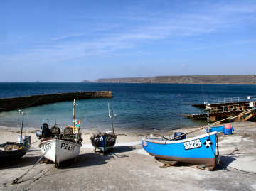 |
When I was in Sennen Cove in poor weather in 2004 and 2005 I was distinctly unimpressed. I was back again in sunny weather in April 2008 and my view is now a little more favourable, though it's still not really my kind of place. What Sennen Cove is is very much a family holiday destination for its superb beaches in Whitesand Bay, the main beach running all along the village and continuing north to become Gwynver Beach (not very easily acccessible). It is also a top surfing destination with the inevitable surf shops and beach café, this one called The Beach. When passing through on a walk from Land's End in April 2008, I enjoyed some excellent sweet potato soup, sitting on the terrace in the sun, watching families on the beach and surfers trying to ride disappointing waves. There is also an acceptable pub, the Old Success, and some other cafés and restaurants, including fish and fish and chips. The well known First and Last pub is not down at the cove but on the main road to Land's End. For more information about facilities try Sennen's website - informative but slightly confusing. And, if they are still up, you should take a look at the remarkable images taken during the storm of 10th March 2008; some are quite amazing and one appeared in national newspapers. |
|
|
Signed off A30 a couple of miles before Land's End |
| As Stratton is close to the English border, you might expect the name to mean "the settlement on the (Roman) road". However, it derives from the little River Stret and means "the valley of the river Neet or Stret". Knowing Stratton previously only as somewhere to pass through on the way to North Devon or to Holsworthy, I was pleasantly surprised when I parked in the free car park on the Holsworthy road and walked up the hill to the church. First, I took photos of attractive Thistledown and Tudor Cottages and of Bridge Cottages across the road. Then I climbed steep Old Post Office Hill through simple Rattenbury Gardens and past the ancient Tree Inn, continuing on up Fore Street to Church Street, a War Memorial, more attractive cottages (see right) and St. Andrews Church. As you approach the church from the lych gate you see a striking (unused) tower entrance, a small statue of St. Andrew above it. Inside is a "clink" door from a former prison. The roofs have carved bosses. There is an elaborate screen, a carved pulpit and an unusual modern brass font cover. Unlike nearby Kilkhampton and Poughill, there are almost no carved bench ends, The Civil War Battle of Stamford Hill took place on 16 May 1643, just off the lane to Poughill; here Hopton's Royalist army defeated Chudleigh's Parliamentarian troops. |  |
| At Stratton on A39 go R on Holsworthy Road. Car Park on L. |
|
 |
The nearest I had previously been to Talland and Porthallow was when walking the Cornish Coast Path between Polperro and Looe in April 2010. The path passes through the two coves of Talland Bay; the tiny villages of Talland and Porthallow [not to be confused with Porthallow on the Lizard] are up a steep hill inland from Talland Bay. There are some attractive cottages in the villages and the child and dog friendly Talland Bay Hotel in Porthallow village is strongly recommended for its location and lunchtime light food. The church of St. Tallanus is in Talland village. It's a most unusual church, set into a steeply sloping graveyard. As you enter the porch, the body of the 13th to 15th century church, uniquely dedicated to St. Tallanus, is to your right, the detached tower is up steps to your left. Inside are some good memorials and a very fine collection of carved bench ends, mostly of the 16th century. Down in the bay, one cove has a car park and beach café, the other a large car park, at its top, behind Smugglers Cottage, the Smugglers Rest café. We visited in 2015, between Christmas and New Year. Car parks and toilets in the coves were closed for the winter. There is a path between hotel and beach but we opted to drive the steep hill between the two. The hotel was dressed inside and outside to entertain children in the festive season. It entertained us, too. |
|
|
Turn S from A38 at East Taphouse, by Pelynt then S on lane |
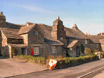 |
At first we hated Tintagel as an awful tourist trap. Now we know it better we find we can ignore the tat and concentrate on the interest. Most people come to seek King Arthur and his Tintagel Castle. For that, park in the designated car park, walk to the Island, climb it, enjoy the views and drink your fill of history, real or mythical. Dedicated Arthurians will also look almost opposite the National Trust's Old Post Office for King Arthur's Halls, an odd mix of Pre-Raphaelite mythology and modern audio-visual. The Old Post Office is really a small 14th century manor house, used in Victorian times as the local mail receiving office. Away from the village, high on cliffs to the west, St. Materiana's church is worth seeing in its own right; close by are ravishing coastal views. On the way there, look out for the Vicarage; enter its ancient gatehouse to find a simple chapel, once a 13th century cottage; look over its garden wall for a medieval dovecote. We enjoy Tintagel for all these things and now think it a shame that most people are unable to see beyond the tourist traps. The village has improved greatly (it cost £2.4 million) but shops, cafés and restaurants are still mostly aimed at the worst end of the tourist trade and almost all rely on the Arthurian connection. Our preferred eating place is the Olde Malthouse Inn. |
|
|
From A39 at Camelford, take B3266 and B3263. More Tintagel |
 |
I was back in Tintagel
at the end of January 2017, this time for a walk with Bob, my neighbour
when we lived on the other side of the river. We did a walk that
I have done many times before, though I have to admit that, in my 80th
year, I no longer find the coast path as easy as I once did. I had
remembered this particular section as fairly level and grassy. How
memory plays tricks; it is quite up-and-down
with some relatively rocky bits in one or two places. Nonetheless,
I coped OK with the coastal bit and found the inland return no problem,
though one or two stiles are by nor means entirely easy. The return
route, past Trevillick Farm, brought us out on Church Road. Just
a few yards down the hill I was able to show Bob, who used to live locally,
a couple of things he didn't know existed - Fontevreux Chapel and the massive
dovecot in the Vicarage garden. We then visited the Church of St.
Materiana which, although I had been in it before, I had paid little attention
to previously. Although they may have been there before, new to me
were the St. Christopher, St. Materiana and Virgin and Child statues on
the north wall. I was pleased to get a photo of the "Roman Stone"
commemorating the Emperor Gaius Flavius Valerius Licinianus Licinius -
quite a mouthful! Bob, away on his narrow boat much of the
year, wants to visit Altarnun and East
Moor next. More Tintagel images |
 |
|
|
|
|
 |
 |
| The Bridge to the Island, opened 2019 |
The "Gallos" figure on the Island |
 |
Tregony is a less than 10 miles from Truro but a world apart. Rather like Grampound it is virtually a one-street village and is on a hill. However, its hill is a great deal steeper than Grampound's, climbing altogether about 200 feet in its half-mile length from the River Fal at the bottom to St. Cuby's Church and the Primary School at the top. At one time the River Fal was navigable all the way up to Tregony, 15 miles from the sea. In those times it was an important port. In the early 17th century King James I gave Tregony free borough status and it was entitled to return two elected representatives to Westminster; no longer of course. Tregony lost its importance thanks essentially to the silting up of the River Fal, due primarily to run off from the chia clay pits and tin mines It is however a delightful village; or is it a small town? It certainly has some of the attributes: Anglican church, Methodist chapel, post office, shop, primary school, and pub, the excellent Kings Arms. Fore Street is lined with attractive cottages, looking 18th century, and there are a few Victorian villas. Notable features include the clock tower, the small square with its parish water pump, and its galleried almshouses, pictured left. These were built in 1896 by M.P. Hugh Boscawen and greatly restored in 1995. Their purpose was "to house poor housekeepers, who must be over sixty and have lived in a 2 mile radius of Tregony for 2 years". |
|
|
Signed off A390 St. Austell - Truro, between Probus & Tresillian |
 |
We drive through Tresillian every time we visit Truro or points west of there. As you approach from the east (our direction) what you see as you enter Tresillian, and prepare to turn sharp right across a bridge over the Tresillian River, is the formal, and normally unused, gates to the northern end of a four mile drive to Tregothnan, ancestral home of the Boscawens, Lords Falmouth. The village straggles along the main road. Along the way is the attractive Wheel Inn and some motor deakers on the left, a former toll house and an old maltings on the right. At the Truro end of the villlage a signed footpath takes you through a small marshy area and on to a firm path which follows the west side of the Tresillian River. The river itself, leading to attractive St. Clement is tidal; at low tide it is almost entirely mud. In spring daffodils line the south side of the road. Before you turn right over the river on the main road, to your left is the Anglican church, dull from the front but attractive from up the track alongside it. To my surprise, a Cornish Cross sits on the kerbside in front of the church. The Victorian church was firmly locked when I was there; I doubt if I missed much, Pevsner is not exactly complimentary. The lane alongside the church leads to St. Michael Penkevil and Tregothnan. |
|
|
On A390 St. Austell to Truro road, 2 miles west of Truro |
| When I walked from Beacon to Clowance on the Land's End Trail, I was really surprised by Treslothan hamlet. All very grey and Victorian gothic but all most beautifully maintained. This was the estate village of nearby Pendarves House and survived intact when the Georgian home of the Pendarves family was demolished in 1955. All built in the 1840s by architect George Whitwick, the church, houses and former school are all of the same silvery grey granite and surround a war memorial. Contrast the number of names on the memorial with the smallness of the village; these must all have been workers on the large but dispersed Pendarves estate. Next to the church is the Pendarves Mausoleum. Buried in the churchyard is self-taught Camborne born poet John Harris. On a corner by woods is the former village well. From here a footpath heads roughly south, first passing the former village school, now a private home, then continuing through fields and woods to the road from Troon to Carwynnen. If you are visiting Carwynnen Quoit, re-erected in 2014 by the Sustainable Trust, this is as good a route to take as any, turning right on the road towards Carwynnen for a short distance, then right through a gate into a field. Immediately inside the gate is a good storyboard; the quoit is across the field. |  |
| 1 mile west of Troon by country lanes |
|
| A walk from Boscastle
in January 2008 took in Trevalga hamlet, Trethevy village, St. Nectan's
Glen and Forrabury church. Trethevey I remember from my early
days of touring when I, unsurprisingly, looked unavailingly for Trethevy Quoit there.
So imagine my surprise when I found at the roadside 'King Arthur's Quoit',
a massive flat rock said to have been hurled there by Arthur from Tintagel
Castle but possibly once the capstone of a real qouit. In the village
on the other side of the road I was pleased to find St. Piran's Chapel
and Well but failed to find the Roman milestone. Trevalga
I researched after hearing from a German who holidays in Cornwall.
A charming hamlet, its last Lord of the Manor, Gerald Curgenven, left it
in 1959 to a trust managed by his old school, Marlborough College.
It's six farms are now just two and its important buildings are away from
the hamlet - the Manor House on the cliffs, the Rectory half-a-mile inland.
My walk included the following: Forrabury church is of little
interest, except for its font and Cornish cross, but leave the north-west
corner of the churchyard and you are on Forrabury Stitches, a medieval
field system maintained by the National Trust. Forget about St. Nectan's
Glen, it is gloomy and the owners of The Hermitage want £3.50 (2008)
to see the famous waterfall! Round walk- Boscastle, Trevalga, Forrabury. |
 |
 |
|
|
|
| UPDATE AUGUST 2018:
Possible
disastrous news! Due to a legal anomaly in the formation of
Marlborough
College's charitable trust, Trevalga estate was offered for sale in
2010 for around £10 million. Not surprisingly,
the tenants were unhappy. But happily the sale came to naught and
the residents can continue to enjoy their charming isolated
village. More on Trethevy More images of Trevalga |
| This Trethevy, just off the road between Tintagel and Boscastle, should not be confused with Trethevy Quoit at Darite south of Minions on Bodmin Moor. Yet, oddly, only a short distance from this Trethevy, and on the opposite side of the road, is a large flat stone known as KING ARTHURS' QUOIT. I visited this Trethevy early in October 2019, primarily totake a look at ST. PIRAN'S CHURCH, or Chapel as it should be known as it is a Chapel of Ease to St. Materiana's Church in Tintagel. I suggest, if there is space, parking in the Rocky Valley Car Park, on the other side of the main road from the lane up to St. Piran's Church. The lane is signed to Rocky Valley and it is only a hundred yards or so up the lane to church and well. There is more than just the church at Trethevy. Diagonally across the lane from the gate to the churchyard is ST. PIRAN'S HOLY WELL, the beehive shaped well house topped by a small iron cross. And, if you turn down the lane at the side of the church, signed as a footpath to Rocky Valley, you will find a ROMAN MILESTONE. This is believed to date from AD 251-3 and bears a rather illegible Latin inscription reading "For the Emperor Caesar, our Lords Gallus and Volusian." A few yards further along the lane is the entrance to St. Piran's House, believed once to have been part of a monastery. The first mention of the church was in 1457 when Parson Gregory received licence from the Bishop to celebrate Mass. A century later, after the Reformation, it was used as a farm building and it was not until 1914 that the owner, Sidney Harris, gifted it to the Church. After restoration, it eventually reverted to use as a Chapel and the first service was held in it on 9th February 1944. Further restoration took place as recently as 2015. Externally, the church is set partly into a small hill and is rectangular under a slate roof. Inside it is quite simple, the nave just a plain rectanguIar space. In the east wall is a small lancet window with a trefoil head. In the north wall an attractive modern stained glass window depicts St. Piran against a background of Rocky Valley. On one wall a plaque commemorates the Reverend Dudbridge Arundel, the vicar responsible for the restoration of the church. Another remembers Sidney Wickett Harris who gifted the building to the Church. The simple altar is made of darkish, slatey local stone. Furnishing is simple with plain wood pews, lacking in carved bench ends. |
 |
 |
 |
| St. Piran's Holy Well |
Trethevy, St. Piran's Church |
The Roman Milestone |
| I was back in Trevalga in July
2018. Parking is not easy; you could park in a small lay-by
on the main road but these days that means more walk than I can
sometimes cope with. Happily I found a small usable space close
to the gate to the churchyard. Previously I had not been inside
the church; this time I did and report on it on my Churches page. |
 |
 |
 |
| Trevalga Church |
Cornish Cross in Churchyard |
Carved Bench End |
Return
to Towns and Villages
Return
to Home Page for Cornwall Reviews Contents
| I visited St. Peter's Treverbyn in mid-October 201`9. At first I thought I was out of luck as the church was locked. However, in the village hall over the road I found churchwarden Rod Phillips who kindly opened up the church and gave me a guided tour. Thank you, Rod. There is not much to Treverbyn village which, as near as makes no difference, is part of Stenalees, the southern continuation of Bugle, towards the eastern edge of Cornwall's China Clay Country. However, a little surprisingly, Treverbyn is the main parish of this part of Clay Country and includes Bugle, Stenalees and Penwithick, Trethurgy, Scredds and Carthew within its extended parish boundaries. Treverbyn itself consists of little more than church, old vicarage, new vicarage, school, village hall, a farm and some recreational facilities. Appropriately for a Clay Country church, Clay Country settlements being mostly relatively recent, St. Peter's in Treverbyn dates from 1848 and was the work of prolific Victorian architect G E Street. This was only his second Cornish church, the first being St. Mary's Par at Biscovey. Pevsner rates this as "good early Street with strong design, simple detail and skilled use of local materials." The exterior is modest with steeply pitched slate roofs. Windows in the north and south walls have Decorated tracery to 2-light windows. The east and west ends have larger 4-light windows. The interior is bold, lofty and spacious. The nave is rather barn-like with its arch-braced roof and a soaring chancel arch. The sanctuary ceiling is boarded and painted. Careful lighting gives prominence to the altar. Stained glass includes two windows on the south wall of the nave. The 1897 windows of the north wall are all by E R Suffling. There are good contemporary wrought-iron gates to the churchyard. Nearby are a few other buildings by Street; his 1858 former vicarage, described by Pevsner as "solid and workmanlike," has a circular stair turret. The school room and school house are also by Street. |
 |
 |
|
| Treverbyn Church | Treverbyn's Alabaster Pulpit |
 |
Although I had been near Troon - south of Camborne - on several occasions when seeking mining relics in the area, it was not until August 2007 that I actually drove through the village. On my way from Carwynnen Quoit to King Edward Mine, I found myself in what I think is Treslothan Road, part of the Pendarves Estate mining settlement. Although I know nothing else about the village - except that it boasts (or certainly has in the past) a great cricket team, I was so struck by the lovely terraced cottages and their long front gardens that I had to include an image of the street. |
|
|
2 miles S of Camborne, by the road past the railway station |
|
One of England's smallest cities stands where three streams meet to become the Truro River. From early times Truro was important, its port serving Cornwall's tin and copper trades - the Coinage Hall in the middle of the city is a reminder of those days. By 1130 it had a royal charter, was a stannary town, regulating the tin trade, and had prosperous merchant guilds. The port has gone but Truro is now county town of Cornwall with a cathedral. It is an attractive small city with a confusing street pattern, some fine Georgian terraces, attractive back-streets and alleyways, some pleasant parks and gardens and handsome old granite buildings. There is a daily 'Pannier Market' on Lemon Quay, and two farmer's markets. Shopping is good and there are many good restaurants, cafés and pubs. Hall for Cornwall hosts theatre and music. We have attended a number of concerts there; seating is good but sound balance can vary. Best hotel is The Alverton, a comfortable country house only a few hundred yards from the centre of town. If you feel like exploring further on foot, you can follow the river for a couple of miles to Malpas, where the Heron Inn (there is a heronry in the woodland along the river) serves good food. Alternatively, you could take the water-bus which runs to Malpas, Trelissick and Falmouth. A mile from from Malpas, on foot along the creek (sometimes a little muddy in places), is the charming little settlement of St. Clement. |
|
|
At the junction of A39 to Falmouth and A390 from St. Austell |
 |
On a sunny day in late April 2016 I had an outing to the south coast to visit Carlyon Bay - to look at progress on "The Beach" (none) - Par Beach and Polkerris. On the way I stopped off in Tywardreath which, when passing through I had always liked the look of, but had never spent time in. The name, borrowed by Daphne du Maurier, translates as "The House on the Beach (or Strand)". As with most Cornich villages, the main feature is the church. St. Andrew's is set in a large sloping churchyard, full of wild flowers when I saw it. Consecrated in 1347, the tower and south aisle were added in 1480. Outside, to the left of the porch, loose stones include remains of a column that guided travellers across the estuary. Inside are Rashleigh memorials, a wagon roof with carved bosses, a decorated 14th century font, a carved pulpit which seems to have been made from either bench ends or part of the former screen, small remains of that screen and some fine bench ends (see the church's Visitors Guide for interesting explanations of these. The village has wide streets with some handsome houses and a pub, the New Inn. Halfway down Well Lane, the well has been sealed off. A little way down the lane on the right is the handsome, and quite unusual, Methodist chapel, still in use. Further down, another former chapel is now a day nursery. |
|
|
Just north of A3082 St. Austell to Fowey road |
| A charming little
village on the Roseland peninsula, not far from tiny Portloe
harbour, Veryan comes in two parts. Veryan itself has a pub, a church,
a post office and stores and a lovely garden. Half-a-mile north-east
is Veryan Green. Both are notable for their pairs of thatched round
houses. They were built around 1815 by Veryan vicar Jeremiah Trist,
as homes for his daughters. They are round to ensure there are no
corners for the devil to hide in. Jeremiah's son Samuel built Trist
House as his vicarage; its lovely garden
used to be open daily from April to July, serving good cream
teas. I have been unable to ascertain whether it still
opens; pity if not. Veryan's church is dedicated
to St. Symphorian and consists of nave and aisle with the tower
standing
alongside the nave. There seems to be some Norman work, otherwise
the church is mainly of the 13t and 14th centuries witrh later
Perpendicular
window insertions. Inside, unusually, the floor slopes upwards
towards
the altar.
A round walk from Carne Beach includes Veryan and Portloe |
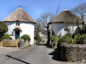 |
| Signed from A3078 to St. Mawes, just south of Tregony |
|
 |
This is my own hometown.
Nothing very much special about it but a very pleasant, convenient place
to live. We chose Wadebridge because we wanted a good small town
close to where Jane was raised in Trebetherick. It has everything
we want: good local shops, a cinema, plenty of activities
and, most importantly for me, it's fairly centrally situated giving easy
access to the rest of Cornwall for my explorations. The town grew
up on both sides of the lowest *fordable crossing of the River Camel
(the original name was Wade from the Saxon gwaed meaning ford) and
had a market by 1312. One of Britain's finest medieval bridges was
built in 1468. Known as the Bridge on Wool, the popular story
is that woolsacks were used as foundations, the truth is almost certainly
that it was financed by wool merchants. Across the river, where we
used to live, is Egloshayle (the name means The Church on the Estuary),
once a separate village and probably older than Wadebridge. Until
the 18th century Wadebridge was an important port, exporting corn and granite;
apartments now line that part of the waterside. The railway once
ran through here, linking the town with Bodmin
in 1834 and later extended to Padstow.
The railway is long gone but the trackbed is now the Camel
Trail, a cycle route so popular that, in summer, it can be almost impossible to walk along it.
*The Camel is still easily fordable in Wadebridge at low tides. |
|
|
Signed from A39, or by A389 from Bodmin |
| Wadebridge Museum: The museum opened in 2007, closed in 2010 and was homeless for 3 years until it re-opened in a brand new building in September 2013. Put together and manned by enthusiastic volunteers, primary feature is a superb and surprisingly comprehensive collection of old photographs with a few old drawings and paintings. Major emphasis is on the famous bridge and on the railway which closed with the infamous Beeching cuts but once ran right through the centre of town. Museum web site. |
| Bridges: The 'bridge on wool' was built in 1468. It was more than 500 years before the town got another. Then it got two in quick succession. In 1991 a new road bridge crossed the River Camel downstream of the wool bridge as part of a welcome bypass Then Challenge Bridge was built in 1993 as a part of a 'Challenge Anneka' TV series. The Culverhouse, also known as the Culverhay or Culvery, is a dovecote, originally serving Trevanion Manor, now conserved by the Cornwall Heritage Trust. |
| This expedition, in late February 2016, started as a revisit to Warbstowbury, a vast iron-age hill-fort not far from Camelford in North Cornwall, and Cornwall's second largest after Castle-an-Dinas near St. Columb. I enjoyed walking the circuit of the banks and ditches of the hill-fort and got some good photos of the views from there, taking advantage of the 800 foot height of the location to include such landmarks as the dishes and radomes of GCHQ Steeple Point north of Bude. I then moved on to Warbstow, passing through Warbstow Cross, a village of no interest. Warbstow itself is tiny, consisting just of farmhouse, ancillary buildings, church and a formerly occupied house, for sale when I was there in 2016. The farm's old barns, mostly no longer in use, are attractively ramshackle. One low building, which might have been a small piggery, has a small double-headed round window opening. The farmer describes it as Norman but it looks Saxon to me. Oddly, the village's name means "the holy place of St. Werburg", a saint normally associated with Chester. I was unable to gain access to the church but underatand it originally to have been 12th century cruciform, an aisle and tower added in the 15th Century and the south transept removed in 1861. Note the coffen stile through the hedge to the churchyard from a lane on the south side. |  |
| From A39 N of Camelford, go R on A395 and L at Hallworthy |
|
 |
I first encountered
the moorland village of Warleggan in June 2006 when Jane and I attended
a flower festival there. It was a warm, sunny day and gardens
were
looking lovely and lush. I was next there in August 2011 in the
course
of a challenging 6½ walk from a car park at the southern end of
Colliford Lake, a walk that took me over Penkestle and Letter Moors,
and
by way of Lantewey, Warleggan and Carburrow Tor. Challenging for
the stream crossing below Lantewey - the clapper bridge had collapsed
in
a flood - and the very steep, massively rocky track up between Lantewey
and Warleggan. On this occasion, in late November 2016, I
approached
the village from the A38 at the Halfway House Inn and, on the way,
discovered
disused Tredinnick Chapel and an adjacent Cornish Cross.
Warleggan
is a fairly steep, one street village. There are some
inaccessible
big houses, accessible small cottages, the former village pump in front
of Pixie Nook (ugh!) and the tiny church up a track off the lane.
There is little to commend the church, which was (as so often) ruined
by
Victorian "restoration". The 15th century font of elvan stone
bears
no decoration. The poor box is old but stands on a modern
column.
There are no carved bench ends, done away with by the Victorians.
To my mind about the only redeeming features are the Cornish Cross,
once
used as a gatepost, by the porch and the fact that you can park a car
by
the
church.
|
|
|
Best approached from A30, down W side of Colliford Lake |
 |
I visited Week St. Mary (originally Wyke St. Mary, the Old English Wyke meaning a dairy farm, St. Mary added for the dedication of the church) in late January 2016. My purpose was essentially to seek out the bare remains of what is claimed to be a Noman castle ringwork just to the west of the church. Certainly you can see some kind of earthwork in the field adjacent to the church but just what it was is unclear from visual evidence, whether castle or perhaps manor house. The village will have been in existence since before the Norman Conquest, after which the land belonged to William the Conqueror's half brother, Robert of Mortain. The market square is attractive with a couple of thatched cottages, a colourful cottage next to the village shop, and a view of the church tower. St. Mary's church, largely of the 14th and 15th centuries, is typically Cornish in that it has nave and north and south aisles, the aisles with wagon roofs. In the porch the floor is of vertically set slate tiles, reminiscent of a Lutyens garden path; underneath a bench is the original village stocks. Inside, the Three Martyrs window is by Kempe; the octagonal font has unusual crude carving; the pulpit has linenfold panelling and a nearby stall looks as if it was made from the former rood screen. The 1814 memorial plaque to Joseph Burnett records the death of the the oldest known official peace officer killed on duty. Note how the word duty has been at first omitted but later added. |
|
|
Signed from A39 at Treskinnick Cross, south of Bude |
| Just off the scenic
north coast road from St. Ives to St.
Just-in-Penwith is a tiny charming village, too easily passed by
on your way west. Zennor consists of just an essentially Norman church,
a cattle farm, the excellent Tinners Arms Pub, a backpackers hostel with
tea rooms, a group of holiday cottages known as Post Office Row, and the
excellent and surprisingly comprehensive Wayside Folk Museum. Legends
attach to the church. One concerns its founder St. Senara, cast afloat
in Brittany in a barrel and washed ashore in Ireland, returning with her
son, Budoc, who was born at sea, via Cornwall where she founded the church.
The short walk to the towering cliffs is rewarding, with views over Pendour
and Porthzennor coves. By the coast path, it's a tough 6 miles to
St. Ives and 11 to Cape Cornwall. However, you may like to consider
the Zennor Churchway, an inland route
between the two, with its return over the hills on the Tinners Way.
In the churchyard are several Cornish Crosses and one lantern cross.
|
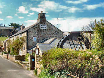 |
|
| B3306
coast road from St. Ives. Normally open Apr - Oct |
|
|
|
|
|
|
|
|
|
|
|
|
|
|
|
|
|
|
|
|