

| Oliver's Cornwall |
|
|
|
|
|
|
|
| This miscellaneous page, one of my Countryside pages, covers a wide variety of landscape and interest and again is largely concerned with walks in the countryside. There are great estates - Godolphin, Lanhydrock, Trelissick, Cotehele, Mount Edgcumbe and Penrose; some major and striking hills - Carn Brea, Carn Marth and Kit Hill; a walk around St. Clether seeking a holy well and Cornish crosses; a literary walk in Daphne du Maurier country. There are also items on two very differant industrial landscapes - Clay Country north of St. Austell and Slate Country in North Cornwall. And more! |
OTHER COUNTRYSIDE PAGES - Rivers and their Valleys and West Penwith
THIS PAGE
- Introduction
and
Online Mapping - Other pages cover Bodmin
Moor, Inland Trails & Inland
Walks
CORNWALL REVIEWS INDEX and SITE CONTENTS
|
|
|
|
|
|
|
|
|
|
|
|
|
|
|
|
|
|
|
Introduction to the Countryside pages
 | One sees and hears
so much about the Cornish coast, its soaring cliffs, its sandy beaches,
its sheltered harbours and the wonderful Coast Path, that it is easy to
miss the fact that there is lots of glorious scenery and some superb walking
inland too. Thank goodness that's the case because there are times
- at school summer vacation and bank holiday weekends especially - when
the roads to the coast just get too congested. At these times we
tend to head for the moors or the mining trails and get well away from
the crowds. I have divided the Countryside section into three.
On this page Miscellaneous includes clay country around St. Austell
and some of the great estates; these walks tend to be easy.
Elsewhere Rivers
flow to both south and north coasts and I include walks in their valleys,
again easy walking, And West
Penwith covers mostly the high moorland to the west of St. Ives
and Penzance. I have separate pages for Inland
Trails and for
Bodmin Moor.
Bodmin Moor speaks for itself, high open moorland that rises at its highest to almost 1400 feet; in places the walking tends to be rocky, steep and difficult but the views are often of both coasts. Since few paths are waymarked on the moor, it is wise to carry both large scale map and compass. The Inland Trails page includes the Tinners Way, the Zennor Churchway, the Saints Way, St. Michael's Way, the Camel Trail, Clay Trails, the Land's End Trail, Mark Camp's enterprising Copper Trail and the Mining Trails. The Mining Trails reflect my own interest in industrial archaeology; since these trails all follow former horse-drawn tramways that served the tin and copper mines, walking (and sometimes cycling) is easy. |
|
| A 'logan' stone is dish-shaped and will rock under pressure |
Online Mapping - Cornwall Council's Mapping Website
 | The recently introduced
'Right to Roam' legislation - long agitated for by the Ramblers Association,
and initially opposed by many landowners - has resulted in vast areas of
land all over England, Scotland, Wales and Cornwall being opened up to
the general public. Essentially these rights are for walkers only
- suits me. I used to find the Countryside Agency's Open Access website
an immense help in my Cornwall moorland walking, not just on Bodmin Moor
but also in West Penwith. Unfortunately the site, now Natural England,
has been messed around with and although the maximum scale is acceptable,
maps are too small and navigation is quite awkward. As a result,
it is no longer worth, as a walker, using it in its current CRoW Access
form.
Fortunately, Cornwall Council has an excellent mapping web site, which I find better for Cornwall than the Open Access site ever was. It is easy to use, shows Open Access land, rights of way, path numbers should you wish to report problems, and is zoomable up to large scale. A word of warning on Open Access land. I soon discovered that this may not be quite as straightforward as that. I have encountered barbed wire fences, locked gates and even one gate on Bodmin Moor, leading to access land, that has a 'no walkers' sign on it. And, in West Penwith, where moorland is lower, I have found impenetrable furze and bramble. So don't expect it to be easy. |
|
| Ordnance Survey Explorer maps now show Open Access land as yellow |
 | There is a great deal more to see and do at Cotehele, one of our favourite places, than just the house and garden. Indeed, if you visit Cotehele and see only the house and garden, you will have failed to get the best out of a wonderful place. If you leave the house by a gate from the back garden, you can walk across meadow to the Prospect Tower. Leave the house downhill, through the Valley Garden, keeping right, and continue right to the Chapel of St. George and St. Thomas a'Becket, better known as the Edgcumbe Chapel, built in 1485 by Richard Edgcumbe after his escape from Richard III's soldiers. Continue through woodland to the River Tamar for the Discovery Centre, with its displays on Cotehele's history and estate, the restored Tamar Sailing Barge Shamrock, Lime Kilns and refreshments at the Edgcumbe Arms. Continue on the lane to a handsome Bridge; just before it take a path to the right to find a Working Watermill, alongside it a Saddlery, Forge and Wheelrights Shop and a Sawpit. If you want a longer walk, from the Edgcumbe Chapel head up-river for three miles to find the fascinating village of Calstock with its impressive rail viaduct over the Tamar. If you can do all that in much less than a day then perhaps Cotehele is not really the place for you. It is for us. |
|
| Car parking at House and down by Quay but not at Mill |
Godolphin Estate and Tregonning Hill
| In 2003, Jane and I had walked on the Godolphin estate, owned by the National Trust, going up Godolphin Hill and enjoying the superb views from there, taking in the moorland of West Penwith, the north coast and St. Michael's Mount, just visible in Mount's Bay. We had also walked by the Hayle River to see the Count House, once part of Godolphin's mining interests. This time, in April 2007, I extended the Godolphin Hill walk to take in more mining interest (the Great Work Mine) and to include Tregonning Hill. I parked near the house and took a track and lane to Trescowe Common. From there I used Rocky Lane to climb Godolphin Hill; this time views were poor but I did spot a probable bronze age barrow. Down then to the Great Work and up Tregonning Hill. Tregonning Hill was the real object of the walk. On top I found a war memorial and toposcope, the pit where William Cookworthy discovered china clay in 1746 and a granite quarry used in the 18th century as a 'Preaching Pit'. I think I found the hill fort but it was so overgrown I couldn't be sure. I followed the ridge south-east to the end of the Open Access land - and found a boundary stone - then retraced my steps and headed north-west to Tregonning Farm. I had hoped to take a bridleway from Lower Sparnon to Godolphin Cross (interesting roadside well there and a decent pub) but the landowner won't allow access. Back onto the Godolphin estate to return to the car. |  |
| OS Explorer 102 Godolphin House |
|
Lanhydrock Estate - Good Walking on a National Trust Property
 | Mid-February 2003, a lovely mild sunny day and we decided to walk on the estate at Lanhydrock. We know the house well and have walked in the woodland garden previously; this time we decided to explore some of the 600 acre estate - a little smaller than in the days when former owners the Robartes family owned some 40,000 acres in Cornwall. We set off from the house, down the Avenue to Respryn Bridge on the River Fowey (salmon and trout), following the river through woodland. On this occasion we continued beyond the estate as far as Restormel Castle (a steep climb but well worth visiting) before returning through Lanhydrock's woodland and the woodland garden. We saw fascinating features - evidence of early tin-streaming and parts of the vast park wall dating from when a herd of fallow deer was kept at Lanhydrock. In early May we returned with sisters Mary and Frances. This time we extended to 8 miles by including the northern part of the estate. It was another lovely walk and wildflowers - bluebells, allium, wild garlic amongst them - were prolific and colourful. The spring garden behind the house was in full bloom, too, and was also immensely colourful. This is one we shall remember to visit every Spring; happily it is less than a half-hour drive from our home in Wadebridge. |
|
| NT Country Walks, Lanhydrock Leaflet. OS Explorer 107 |
| Since the very early walk reported on above, we have walked on the Lanhydrock Estate scores of times. Every time one of my sisters comes to stay, when their train arrives at Bodmin Parkway around mid-day, the first thing we do is walk at nearby Lanhydrock. The old carriage drive from the station to the Respryn Gate still exists. Sometimes we use this, more often we use the NT car park at Respryn Bridge, particularly when we walk our friend Chrissie's lovely collie Meg, who knows the way around Lanhydrock better than we do - and even knows the right bench at lunch time. |
| The Cycle Hub: Cornwall seems to have become mad about the bike. The Camel Trail, the Mining Trails, the Clay Trails, all these aimed at the cyclist. Now (2014) Lanhydrock's main car park has had a 'Cycle Hub' added and the north-eastern part of the estate is now devoted to cyclists, some of whom have a tendency to assume that the footpaths are for their benefit, too. Not far from Lanhydrock, and to the east of Bodmin, is more cycle friendly woodland at Cardinham Woods. |
 | In March 2007, Jane's sister Mary and her husband John were down from Northumberland and staying in a lovely rented cottage at Brixton in Devon. We decided to meet up for lunch and settled on the Edgcumbe Arms in Cremyll, just across the water from Plymouth. Mary and John used the Torpoint Ferry from Devonport. We met at the Maker Church free car park, at the top of the long hill down to Cremyll. It was a glorious sunny day so, to work up an appetite for our lunch, we walked for the best part of a couple of hours on the lovely Mount Edgcumbe Estate. The people of Plymouth, and those of south-east Cornwall, are fortunate to have such a wonderful place to walk. The estate is very extensive, covering a thousand acres between Cremyll and Kingsand and continuing as a coastal strip beyond Kingsand, to Rame Head and then on all the way to Whitsand Bay. A path leads across fields from Maker Church to the Barrow car park and down towards the house. We headed off south before the house and took in the Folly, the Temple, the Blockhouse and the Italian Garden, finishing up on Cremyll waterfront for our lunch. A delightful walk in a delightful estate, which even included part of Mount Edgcumbe's famed National Camellia Collection - and all that for free, including the car parking. Mount Edgcumbe House and Garden. A round walk from Kingand includes Maker, Empacombe and the estate. More Mount Edgcumbe photos below |
|
| Parking at Cremyll and two locations on the estate (one free) |
| Jane and I were at
Mount Edgcumbe again in April 2009 (and many times since).
It was a glorously sunny day and again we parked in the free car park by
Maker church. Walking down to the house, the views over the Hamoaze
and Plymouth were superb. Though we didn't go round the house, we
did go round the Earl's Garden where rhodos were lovely. After lunch
in the Orangery in the Italian Garden we wandered around the formal gardens
and along the waterfront before making our way back to the car past the
National Camellia Collection. A delightful day.
NEWS FOR 2010: Work has finished in the yard adjacent to the house and there is now a new restaurant/café there. |
| CANTEEN at MAKER HEIGHTS: Strongly recommended as a place to eat. Very varied and enterprising menu includes meats, fish, salads and veggie. Seems to be open most days 9.30-4 but check Facebook page for opening and menu. |
More Images of the Mount Edgcumbe Estate
 |
 |
 |
|
|
|
|
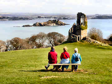
| This is one of the National Trust estates where we like to walk Meg the border collie. I visited the estate on my own in March 2007 on a gloriously sunny day for photos of The Loe, Loe Bar and Porthleven. I used the car park where the Porthleven road leaves Helston and did a clock-wise circuit extended to 10 miles by walking from Loe Bar into Porthleven and back to lunch at the Ship Inn. The Penroses were here for at least 500 years but sold to the Rogers in 1771. The latter gave it to the National Trust in 1974. During WWII Penrose House was used first by the British Army, then the Americans. Loe Bar was mined and booms prevented enemy seaplanes landing. Lower Pentire (now a holiday rental) was a centre for torpedo research. This is a delightful place for an easy walk - nowhere do you climb to more than 100 feet and tracks are in good order. Where the River Cober leaves Helston it would be marsh were its course not contained by man. The marsh around it is filled with water tolerant trees, mostly alder and willow - a bit eerie and rather like a mangrove swamp. In 2008 Jane, my sister Mary and I had another pleasant Penrose walk, this time parking in Helston, walking the estate and continuing to Porthleven where we enjoyed good fish and chips from Roland's, sitting in the sun by the harbour. |  |
| OS103 and NT leaflet. A Coastal Round Walk incl. Penrose |
|
 | Like most of the great estates open to the public in Cornwall, Trelissick is National Trust. Most who visit go for the delightful gardens. They miss a fascinating estate. Jane and I have walked all around it many times, basing our walks on the National Trust's Cornwall leaflet 17. The estate extends to both sides of the road down to the River Fal and King Harry Ferry. To the south is open grassland, with views across the Fal to Turnaware Point, and woodland along the river to King Harry Ferry. To the north are woods to and around Lamouth Creek and back around the river to the ferry. Our preferred walk is to stay south of the road to Old Lodge, cross the road to a byway north downhill to a path west through Namphillow Wood to Lamouth Creek, cross a bridge then east through Lambsclose Plantation to Roundwood Fort and Roundwood Quay. (If very muddy in Namphillow Wood, use a byway to the north of the NT land) We then like to head back along Lamouth Creek to the bridge and follow the creek and River Fal through Stitches Plantation and North Wood to King Harry Ferry. Depending on the time of year, we may then follow the river south through South Wood, returning to the car park across pastureland; or we may take the lower garden entrance to enjoy a gentle wander around the delightful all-season garden, open almost all year. Full walk about 4½ miles. |
|
| OS Explorer 105 and NT Walk Leaflet 17 |
| Roundwood Quay, now a tranquil spot with delightful views across the Fal, was once a hive of industrial activity. In the 18th and 19th centuries it shipped tin and copper smelted and refined on the quay. When the trade declined in the 1830s it continued to be busy building ships of up to 60 tons. There was also a maltings and a lime kiln. West of the quay, in Round Wood itself is an iron age promontory fort. Roundwood Fort has two massive banks and ditches and an oval earthwork. Outlines can be a bit unclear due to plant growth. |
| When we did this walk in early February 2009 it was primarily to see the effects of the recession on world trade. The Fal, as a drowned valley (ria) is a deep water river and ships out of commission park up north of King Harry Ferry. We saw seven ships, including a couple of massive car transporters. We were told that three more were parked up a bit further north. I remember seeing several back in the 1950s but never that many. In October 2012 the massive car transporters were gone; in their place were several refrigerated fruit carriers. |
Clay Country - Alien Landscape North of St. Austell
| South of the A30, north of St. Austell and covering in all some 25 square miles, is a ravaged and alien landscape. As you drive along A30, or the southern A390, or even the northern A39, you get hints of it - a long range of flat topped hills with occasional white conical peaks which gave the area its old nickname of the Cornish Alps. But you need to drive up onto the clay lands to appreciate what the area is really like and why. Until 1746 fine porcelain had been a Chinese monopoly. But then apothecary William Cookworthy found china clay (kaolin, a form of degraded granite) on Tregonning Hill near Helston. Now the main area mined is above St. Austell. Without its china clay industry this would be high moorland, much of it around 1000 feet. As you drive through it you get only glimpses. To see more you need to leave your car and climb protective banks to look down into vast white pits where high pressure water cannon scour the rock. Once the processing was done on site; now it happens in vast factory sites. To learn how the industry worked, and to get a view of a working pit, visit Wheal Martyn Museum in the heart of the clay fields. And you should also make a point of seeing Charlestown harbour built in Georgian times to export the china clay but now a visitor destination for its tall ships and Shipwreck Museum. Pentewan harbour was another shina clay export location. Now clay is shipped from a deep water terminal up river at Fowey |
|
| June 2005 - Now see more of Clay Country on the Clay Trails |
Slate Country - North Cornwall around Tintagel and Delabole
| Slate is a Devonian
metamorphic rock formed by pressure on mudstones or shales. Wales
has always been Britain's main slate producer but North Cornwall has a
belt of slate, the best of which is found in the area around Delabole,
Tintagel
and Trebarwith. Slate has certainly been quarried in Cornwall for
1000 years and more. Once men hung from the cliffs near Tintagel,
hacking out the slate. Those quarries are long closed and slate,
originally a cheap roofing material, has become more of a luxury item.
Major working quarry is now Delabole which employed 1000 men in 1859. Now its workforce is just 40 producing, albeit it with much mechanisation, much the same output as then. The five Delabole quarries united as one in 1841. From 1977 to 1999 it was owned by RTZ but is now back in private local hands and producing the same 120 tons daily as in 1859, thanks to its modern equipment. The vast waste tip (modern quarrying produces little) has been landscaped with walks, seats with views and, on the top, a modern Slatehenge. A visitor centre offers a video and seasonal daily tours of the surface works. A walk round the quarry perimeter takes a good half-hour but what was once the largest hole in Cornwall is now dwarfed by some of the great china clay pits to the north of St. Austell. |  |
| Parking at Delabole Quarry. Photo of Slatehenge |
|
| A visit to Carn Brea
in 2002 was little more than a taster. At that time, in spite of
Jane's Cornish roots, we knew little about its history, landscape and archaeology.
So, when a window opened in the generally poor weather of November 2006,
I took the chance to revisit. I parked by Cowlin's Mill, used the
Great Flat Lode trail to the eastern foot of the slope, and climbed the
hill for a more thorough east-west exploration. Afterwards I walked
down to the excellent Countryman for lunch and returned using another part
of the Great Flat Lode trail. The weather was good on the hill but,
after being battered by a hail storm on the way down I was glad of the
Countryman's fire.
I was struck by the sheer length of the hill - a full mile - by the superb views - the Cornish Alps to the east, St. Agnes Beacon to the north, St. Ives and West Penwith's hills to the west - and by the surprising number of rocky tor outcrops along its length. Even more than the tors and Carn Brea Castle, the most outstanding feature is the Basset Monument, visible for miles around. The archaeology is a disappointment; all that is visible among the furze, brambles and bracken are some hut circles and the odd standing stone. Despite that, it was a great experience, and I was pleased to have taken the chance to revisit Carn Brea, something I have done many times since. |
|
| Carn Brea Revisited 2007 - Carn Brea's archaeology - a Carn Brea Walk |
Carn Brea 2007 - an archaeological and industrial guided tour
 | I suppose this item
might equally belong in the Industrial History section of my Museums page.
However, while the guided tour, ably led by ex-miner Mark Kaczmarek with
occasional assistance from Frank Richards, was part of the County Council's
programme of events relating to the World
Mining Heritage Site, it also included some archaeological interest
up on Carn Brea and more than a fair sprinkling of tall tales from Mark
about the Giant Bolster. So here it is on a countryside page.
A strong turnout of 30 or so met in the car park of the Countryman at Piece on a September 2007 Saturday. We headed up the western end of Carn Brea, stopping to learn about the burrows (mine spoil heaps looking for all the world like gigantic long barrows) that litter the hillside. As the sea mist rolled in we were shown archaeologial remains, strangely shaped rocks and an ancient well below Carn Brea Castle. Coming down off the hill, we visited West Basset Stamps and the comprehensive remains of South Wheal Frances. We finished back at the Countryman where some of us lunched, some enjoyed the real ale and, sadly, some who had enjoyed free car parking left without even having a coffee. Thank you Mark for another entertaining guided tour. |
|
| You can drive up from Carnkie village. A Carn Brea Walk |
| The most prominent feature of Carn Brea is the massive monument to Francis Basset, Lord de Dunstanville. Basset (1757-1835) was prominent in both mining and banking. The family, Norman in origin, had lived at Tehidy, to the northwest, since at least the 13th century; sad that they are no longer there. They must have had interests in Falmouth as its most charming street of all is Dunstanville Terrace. Francis Basset features, in a sympathetic role eventually, in the Poldark novels. |
Carn Marth - the next hill east from Carn Brea
 | When we did the Redruth
and Chacewater mineral tramway walk in August 2007, ably guided by Mark
Kaczmarek, Jane was very much taken with the detour we took up Carn Marth.
I had been up there before and liked it so I was happy to take up Jane's
suggestion that we revisit the hill and take a circular walk on clear paths.
We parked in the same place as on the tramways guided walk - close to the
covered reservoir at the very top end of Lanner. The great attraction
of this spot is that it is handy for several trails and paths - the Redruth
and Chacewater, the Tresavean
Trail and a track heading towards Seleggan and the Great
Flat Lode Trail.
It surprised us to learn that Carn Marth, at 775 feet, is actually 20 feet higher than Carn Brea. But, when you get up there, you realise how much better the views are. North-east to St. Agnes Beacon, east to the hills of Clay Country, south to Carrick Roads and Pendennis Point. There is a fair bit of interest up on the Carn, too: three granite quarries, one with a small amphitheatre created in it, another filled with deep water, blue when the sun is out; and several attractive farmhouses on the lower slopes. Our route took us past Myrtle Farm, Carn Marth Farm and Gordon Farm. Back at the car we enjoyed Jane's superb pasties before a walk along the short but interesting Tresavean Trail. Lanner Hill walk. Tough Carn Brea walk. |
|
| Carn Marth is on OS Explorer Map sheet 105 |
Goss Moor - A National Nature Reserve and 'Multi-User' Trail
| Not long after the new A30 was completed around Goss Moor, avoiding the dreaded iron bridge, the moor was dedicated as a National Nature Reserve and an 8 mile 'multi-user' trail was opened with great fanfare in April 2008. Jane and I decided to take a look in June 2008. We were disappointed from almost every point of view though, not being naturalists, we can't comment on the quality of the nature in the reserve. My first criticism is that for walkers too much of the trail is on roads (admittedly quiet) and that there is not a single seat all the way round. For horse riders only the northern and southern sections have suitable surfaces. For cyclists it's probably fine. Second, the most interesting section, the southern leg, is ruined by a double row of massive electricity pylons. Third, there is not yet signage pointing to the trail start points and none along the trail itself where options occur though I understand that they will be installed, as will some seating. Fourth, and the list does seem to go on, it has been suggested on local radio that you can park for free at the Screech Owl Sanctuary and get refreshments there. Neither is true unless you are prepared to pay the full entrance fee. All in all, this is really not a trail for walkers. It's probably fine for cyclists, bringing their own bikes or hiring at the Sanctuary. |  |
| Map of the trail and reserve - BHS Access Cornwall web site |
|
| A map in Natural England's
Goss Moor brochure suggests that a trail continues to link with the Clay
Trails at Bugle. I investigated this. In July 2008 there is
no cycle trail; a horse trail has been started but runs only
for a mile and is closed off at present because of the danger of negotiating
the old A30 Iron Bridge. Work is proceeding slowly towards Roche
and the Iron Bridge problem remains to be resolved. SEPTEMBER
2010: I don't think it will be completed so I have devised my
own 6 mile walkers route from Goss Moor
to Bugle, linking with the trail to Eden.
FEBRUARY 2014: A new Round Walk from near Tregoss Crossing, taking in Belowda Beacon and Castle-an-Dinas |
Gweek - a walk to find a clapper bridge
| My Guild of Cornish Hedgers friend Robin Menneer had told me about clapper bridges at Ponson Tuel near Gweek so, at the end of March 2008, I set off to find them. I parked at Gweek - difficult in the season - and did a walk of my own devising (OS103). I headed west above the Helford River to Mellangoose, south to Rose-in-the-bush, then roughly east on byways and (on a difficult to find path) down to Ponson Tuel. Finally, roughly north on busy Gweek Drive back to the little village. I was a dull day but, happily, the only shaft of sunlight came at the clapper bridges. A delightful spot, on a quiet lane in beech woodland, with a ford and the two clappers, the smaller presumably over a former leat - the Cornish Pons an Tywel means bridge by the conduit. Unfortunately, the woodland, like most around the Helford River, is private. I had hoped also to post an item about Gweek but tide and weather prevented decent photos - the one below is an old one - so later, I hope. What I can now tell you about Gweek is that the tea garden opposite the pub is excellent. |
 |
 |
|
|
|
| We chose a perfect day in February 2006, when sister Mary was staying, to walk on Kit Hill before visiting nearby Tavistock. There is a lot of interest up here. Remains vary from a bronze age cairn, through a great Georgian earthwork folly and quarries that exported granite as far as Singapore, to mines that worked into the 20th century. On the crest a handsome mine chimney stands on the folly. Views are ravishing, south to Plymouth Sound, east to Dartmoor, north and west across miles of Cornwall. There is ample parking near the park entrance and near the top of the hill. A seasonal café is across the road just before you reach the entrance. This is definitely a place to revisit with more time to spare. |
 |
 |
|
|
|
Around Menabilly - a Literary and Antiquarian Walk
| When walking between
Par Docks and Polkerris I had
passed Kilmarth,
Daphne du Maurier's
last home. Since my circular coast path walk was only 5 miles, I
decided to do some further research to see if I could take a photo of Menabilly
(Manderley), and find the Tristan Stone and the related Castle Dore.
I moved the car from
Polkerris
to the Menabilly Barton car park (the honesty box is a milk churn at the
farm) and set off down to Polridmouth Cove. This is the southern
limit of the Rashleigh family's Menabilly Estate. From there I walked
up through the National Trust's Coombe Farm Estate, up the lane beyond
Lankelly Farm, then right for the Tristan Stone. Returning to Lankelly,
I turned west on the Saints Way and then back down to Polkerris before
I remembered that the car was no longer there. Back I trudged, up
through the woods and across the fields to get to the lane down to Menabilly
Barton and the car. To my delight, on foot this time, I found the
west lodge to Menabilly and a photographable distant view of the house.
A successful day concluded by finding a pull-in close to Castle
Dore for photos of this historic site before heading back home,
tired from ten or a dozen miles walking.
Round Walk from Polkeris, by Gribbin Head, Readymoney and Saint's Way |
 |
| All on OS Explorer 107. Generally easy walking. |
|
| I walked in Tehidy
Country Park for the first time in September 2007, in the course of a different
walk from Portreath to Gwithian, part inland, part coast. My purpose
was to see what progress had been made on the Portreath
Branchline Trail (little then) and to see whether the Tehidy Trail
was complete. The Portreath Branchline had some way to go (finished
now) but, except for its beginning at Portreath, where it shares the initial
climb with the Branchline Trail, the Tehidy Trail is more-or-less complete.
I entered the park at East Lodge, walked along past the golf course and
through fairly dense woodland to Coombe before heading north to join the
Coast Path. The Tehidy Trail has been constructed to cycle and wheelchair
standard but seems to be used mainly by dog walkers. It's not really
my kind of walking and it seems to me a great shame that so many trails
in Cornwall that have been made to a high standard at great expense should
be so little used. After I had completed my Portreath to Gwithian
walk, I parked at South Lodge for some photos of the lake.
I have to confess that, like the trail through the park, I didn't find
the lake very interesting either.
Click here for a Coastal Round Walk from Portreath. |  |
| OS Explorer 104. Parking at East Lodge |
|
| Tehidy was home to the Bassets, mine owners and bankers. The estate was sold in 1919 and the great Georgian house became a hospital but was destroyed by fire. Cornwall Council acquired the 250 acre wooded estate in 1983. There is a golf course and some private housing but most is open to the public with well made tracks and paths around the woodland and lakes. There is an excellent café by the lakes. |
| Update 2010: Both Portreath Branchline and the Tehidy Trail have now been completed. The Branchline happily links with the Great Flat Lode Trail at Brea village. Sadly the Portreath Incline was not able to be restored but an alternative route climbs the hill to Gwel an Mor. |
| Update August 2013 - Refreshments. We used to recommend Polcrowjy as a simple dog-friendly café at the western end of the trail at Coombe. Its straightforward food is good but we now feel that it is too expensive for a simple owner-run café in a shed with almost no overheads. We think £3.30 for a fried egg sandwich too much and £2.75 for a very small pot of Earl Grey tea for one, that turns out not to be Earl Grey, too expensive for this kind of place. When we queried the cost, we received a fairly offensive 'take-it-or-leave'it' response. We now prefer to use the café at Tehidy Country Park visitor centre near the South Lodge entrance and car park. A pot of of Earl Grey tea (yes, it was) for one was £1.55 and excellent cakes are less than £2. Lunchtime soup is usually very good. Some outside tables overlook the small lake. |
Three Ancient Manors near Bude - a countryside walk
 | Late September 2006
and I had just bought new boots - Meindl Burmas - and decided to avoid
the hazards of the coast path and the high moors for their breaking-in
walk. I had read recently about a long abandoned moated manor house
in Poundstock parish but near
Week
St. Mary, a late Norman manor called
Penhallam.
Consulting the appropriate Ordnance Survey Map, I figured out an easy country
walk using the Penhallam car park. A half mile woodland walk took
me south to the site, then I headed east to Ashbury to find a primitive
farm and some iron-age earthworks. Back past Penhallam, south to
Sudcott, an expensive looking farm with overly neatly massacred hedgerows,
no Cornish hedges in these parts. West and north then on lanes and
field paths to find a beautiful longhouse and a sunken green lane at East
Hele farm. Over more fields to find my second manor, the elegant
Georgian Gothic fronted Newmill Manor; in August 2004, when
Boscastle was so badly flooded, the river here rose about 10 feet and must
have flooded the house. (Nov 2015: Newmill Manor no
longer visible over new high gates, shame!). I continued north to
my third manor, Penfound, where owner Richard Betts clearly enjoys his
privacy but at least I was able to get a good look at the ancient Manor
Farm, very Thomas Hardy! I returned by much the same route but omitting
Sudcott and Ashbury. One of the few Cornish walks that has felt like
English country. |
|
| On OS Explorer 111. |
| Richard Betts, owner of Penfound Manor, clearly enjoys his privacy; chains and a 'Not open to the public' sign discourage a close view. A shame as the Tudor and Stuart house is built around a medieval hall. But I did like his Victorian private post box. At least I was able to get a good look at the farm - modern red-brick front hides an older building and the farmyard behind looks like something out of Thomas Hardy and parts probably date from Tudor times. On a 2015 walk I was able to get a slight view of the house and its Cornish Cross. East Hele farm looks decidedly prosperous and the handsome longhouse (the animals occupied the left part) is probably now a holiday rental. |
Tywarnhayle - a round walk - Chapel Porth, Porthtowan, Mount Hawke
| A mild and wet October 2006 had gone, in its place a chill and bright November. Peter Stanier's Cornwall's Mining Heritage had a description of Tywarnhale and Wheal Ellen mines behind Porthtowan, so I walked from Chapel Porth to Porthtowan along the coast, then over the hill where the mines are sited to Mount Hawke and back by Mingoose. The coastal section was superb with long views south to Godrevy Head and Light. Porthtowan is a dreadful little holiday and surfing village with one saving grace, Blue, the parent bar to our defunct favourite Blue South in Falmouth. I had a good coffee there. It was a struggle up to the mines and worse coming down again as I missed the path but the mine remains were worth it. A 'Gold Path' then led up to Mount Hawke village, through delightful beech woodland and past a well hung with votive offerings. Mount Hawke's pub is in the old Victorian school; more good coffee. Then by Mingoose and down Chapel Combe, past the remains of Wheal Charlotte, to return to Chapel Porth. The sun was leaving Chapel Porth but the superb beach café was open so more coffee to finish the day. Altogether I did around 8 miles of relatively easy walking. |  |
| OS Explorer 104. NT parking at Chapel Porth |
|
Hamatethy Down and Helsbury Castle - walked from St. Breward
 | The purpose of this
walk - my last of 2006 - was to take a look at Helsbury Castle, an iron
age hill fort just off the road from Camelford to Bodmin and fairly close
to Michaelstow. I didn't choose a very good day for it. The
forecast had promised sun until midday but when I left St. Breward there
was already heavy cloud and long before I got as far as Helsbury Castle
it was absolutely bucketing down. The result was that I could get
no decent photos of the fort which I shall revist in better weather.
However, that didn't spoil the walk which had a lot of interest along the
way.
My route took me north from St. Breward on the road, then down a lane towards Hamatethy and then up over Hamatethy Down to Henon and Trecarne. The Down was clearly highly populated at one time as cairns, hut circles and field boundaries are clearly in evidence (if not all on the map). At Trecarne Ford I was grateful for the clapper bridge as the River Camel was in spate. Lanes (and a bit of busy road) to Helsbury Castle, then a mixture of lanes and cross country back to St. Breward by Treveighan, Michaelstow and Fentonladle. A fairly easy walk of six miles or so with a total climb of around 900 feet. Usual great panino - in front of a roaring fire - at the Old Inn. |
|
| OS Explorer 109. |
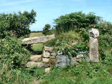
St. Clether and the Inny Valley
| In May 2007 I parked by St. Clether church to find St. Clederus holy well and chapel and some Cornish crosses. First an out-and-back, north-west up the Inny to find the chapel and well; then a short out-and-back west for the two crosses; lastly I looked at Elizabethan Basill Manor to start a four mile round walk to the south of St. Clether. I found the chapel and well with no trouble. On the second leg I found a very impressive 8ft tall cross by walking the wall of a leat that once served Basill's derelict water mill . Another cross I found by entering a field on the right at the top of the hill beyond Basill; very truncated, it is invisible from the road. My third leg took me south from Basill Manor, through woods and fields to Trecollas Farm, then south-west on a lane to the Rising Sun Inn, and finally north-west by Polgray Farm, up a delightful green lane and over fields down to the River Inny and up again to St. Clether. An enjoyable walk on OS 109 Bodmin Moor. Another Inny walk with full detailed directions. |
 |
 |
|
|
|
 | I enjoy Cardinham Woods less than I once did. When first here, walking Mark Camp's enjoyable Copper Trail, this was peaceful woodland, part broadleaf, part coniferous, and used mostly by dog walkers through the week, families at the weekend. Parking was free, there were no facilities and it was a pleasure to walk in the peaceful woodland. Now things have changed. Many will think they have changed for the better but for me the peace and tranquillity is a thing of the past. The Forestry Commission has decided to popularise their woodland by appealing primarily to the cyclist. When I arrived on a May Saturday, the large pay car park was crowded, most cars with cycle racks. Efforts have been made to separate cyclists and walkers but that doesn't work everywhere. The main walk, to Ladyvale Bridge, now has a rock hard surface, not good for walking. The clapper bridge at Lady Vale, to which one used to be able to gain access, is now completely fenced off. New storyboards describe the wildlife, a good thing, but I don't like the cut-out creatures pinned up in trees, part of the same initiative that had harnessed the Gruffalo stories to appeal to children. Fortunately, the extreme cycle tracks are mostly tucked away. Woods café is good and sensibly priced. For a woodland walk near Bodmin, I much prefer the Lanhydrock Estate. |
|
| OS 107 and 109 and a downloadable leaflet |
| CARDINHAM WOODS WALKS: I have devised a series of three round walks starting in the Cardinham Woods car park |
| In mid- May 2017 I visited Crowan and Clowance. I had only been there previously whan walking the Land's End Trail in 2009 and had not then lingered in either place. This time I was in search of Cornish Crosses. First I visited Crowan Church where I found a cross head on a plinth near the porch. Inside the church the rood stairs are still in place but, of course, no rood. There is some colourful stained glass and an elaborate St. Aubyn memorial. Down the road towards Clowance is a former mill, still with its waterwheel in place. Then I parked in the car park near Clowance House and spent a couple of hours walking the estate, primarily in search of more Cornish Crosses. There are three stone crosses, one near the Golf View Apartments, one behind cabin number 17, and a third, sadly invisible, on an island in the lake. By the path, to the north-west of the lake, a sign explains the Cornish Crosses and has a few words about Cornish Saints, tooI walked around the lake and past the little boathouse. There is an entetaining feature in the grounds to the west of the house: a Greek Temple with, to one side of it a set up chess board, to the other draughts. |
 |
 |
| Clowance Temple |
Clowance Boathouse |
|
|
|
|
|
|
|
|
|
|
|
|
|
|
|
|
|
|
|