
| Oliver's Cornwall |
|
and St. Austell area |
|
|
|
|
|
|
|
|
Text and images should align. To view this page at its best, adjust your zoom to fill screen width
ON THIS PAGE
|
|
|
THE INDIVIDUAL TRAILS - Described for Walkers
|
|
|
|
|
|
AND A TRAIL TO LINK GOSS MOOR WITH THE BUGLE TO EDEN CLAY TRAIL
| Goss Moor Link: From the outset you see Clay Country. Last 4 miles in Clay Country, so I class this as a Clay Trail |
OTHER WALKS IN CLAY COUNTRY
| Clay Country Short Walks Short walks from Stenalees, Scredda and Hensbarrow Downs |
|
|
|
|
|
|
|
|
|
|
|
|
|
|
|
|
|
|
|
The Clay
Trails - Cyclists, Horse Riders and Walkers
|
We were delighted when in June 2005 the new Cornwall Clay Trails opened, in conjunction with improvements at the Wheal Martyn Museum of China Clay. It took a lot of co-operation and clearly a considerable amount of money to complete the project. The bodies involved included the then Cornwall County Council, the Eden Project, the National Cycle Network people Sustrans, the Lottery Fund and Imerys, the company that operates the vast clay fields. The Clay Trails are essentially Cycle Trails. Paths are wide, firm and well drained, the few gradients are relatively gentle and their clear local purpose is to encourage people to arrive at the Eden Project (they all go there - once) by bike or on foot. There are effectively five Clay Trails. Wheal Martyn to Eden, with a detour towards Carthew, definitely the scenic trail and the best for walkers. Bugle (where you can rent bikes) to Eden, not very scenic, except for a detour on foot round Treskilling Pit. Par Beach (near the former Imerys clay exporting harbour) to St. Blazey, with a footpath extension to Eden and a cycle route extension to St. Austell. And Wheal Martyn to St. Austell, continuing south as a cycle route to link with the Pentewan Valley Trail. Waymarking is good, sometimes using massive granite blocks, and explanatory displays have been installed at some of the points of interest. Occasional shelters have domed grassy roofs. Although these trails are essentially for cyclists some of them are well worth walking, too. |
|
|
Trails website. Were the Clay Trails worth all the expense? |
| Update August 2010. I learned from late surveyor and map maker Ernie Biddle that there were additional off-road links to the clay trails. If you are on the Pentewan Valley trail to the south of St. Austell, you will find cycle continuations to Heligan Garden and Mevagissey. And a link was planned from the Goss Moor Nature Reserve trail to the trail from Bugle to Eden. It hadn't happened by 2012 so I devised my own walkers trail here. I rewalked all the Clay Trails during the latter half of 2010 and have now uploaded detailed individual entries. |
Were
the Clay Trails worth all the expense?
| When the first of the Clay Trails opened in 2005 I was full of enthusiasm. Indeed Jane and I walked the very first, from Wheal Martyn towards Eden, before it opened. Later I did the same for Wheal Martyn to St. Austell. I enjoyed my walks but with qualifications: except for the Sky Extension on Wheal Martyn to Eden, and the views of St. Austell Bay approaching Trethurgy, there is not much scenery along the way. Perhaps cyclists don't notice scenery. In August 2007, while waiting for the weather to improve for some photos at Wheal Martyn, I walked from there to Eden and back and started to wonder whether we taxpayers have got value for our money. I think not! Because I had the trail almost to myself, I counted how many people were on it. In 10 miles there and back I saw 5 local dog walkers, 2 couples having short walks - and just one walker and 2 cyclists doing the trail. And this in the height of the holiday season. Where were the streams of cyclists (for whom the trail was created at great expense) heading for Eden? The answer was nowhere. What a waste of money! And now more fortunes are being spent on planting new woodland (being overwhelmed by the dreaded rhodo ponticum) and recreating the old heathland habitat (which is recreating itself naturally anyway). Wouldn't it have been nice if, instead of clay trails, the money had been spent on clearing, maintaining and signing the many miles of lost footpaths for which Cornwall Council has responsibility? |
|
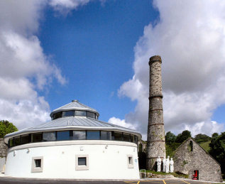
| Wheal Martyn Museum - known as China Clay Country Park |
|
| UPDATE AUGUST 2010: I wrote the above a few years ago. To be perfectly fair, now that I have again walked the Clay Trails, I have found more cyclists on them than before. Pentewan to St. Austell is fairly well used though I saw few between St. Austell and Wheal Martyn On the other hand, when I walked Wheal Martyn to Eden and Bugle to Eden on a sunny Bank Holidy Saturday at the end of August 2010, I counted a total 7 cyclists, not many for 11 miles of trail. So, I retain my doubts about the Clay Trails. |
The Individual Trails
Wheal Martyn
to The Eden Project - 5 miles
 |
I had walked this three times before, once walking part of it with Jane before it even opened. Walking it again in August 2010, I was reminded that this is probably the best of the Clay Trails. Very little of it is on roads, a mere quarter mile or so. Near the start is Ruddlemoor ‘Village Green’, created by the villagers, then you cross the road on a bridge and pass through what may have been a holding tank, with stop board slots in the wall. After the junction with what I like to call the White River Trail there is a fairly steep climb through woodland, thick with rhododendrons, of some 250 feet up to an unsigned fork. You must go left here to enjoy the heather and ferns on the way to a rustic shelter with superb views over the valley to modern Wheal Martyn pit. Back on the trail proper, the walk is then more or less level for much of the way, until it starts to drop down to Eden from Trethurgy village. Along the way you pass close to Carluddon ‘alp’ then the massive abandoned Great Carclaze Pit and another rustic shelter. All along here tracks head off right as permissive paths. Approaching Carn Grey Tor, you get a superb view over St. Austell Bay to Pentewan Sands, Polkerris and Gribbin Head. If you venture off trail at Carn Grey Tor, you will find an attractive small flooded quarry. |
|
|
Cafés and free parking at Wheal Martyn and Eden |
| Update August 2013 - Signage: Occasionally, when I fancy a shortish 'out-and-back' walk on a good surface, I like to park in an unofficial car park, much used by dog walkers, on a bit of old road at Scredda, just off the modern A391. In August 2013 I parked there to walk to Eden and back, a roughly 7 mile walk. It absolutely pelted with rain but at least the surface underfoot remained easy to walk on. After lunch at Eden - OK but not brilliant - I walked back, now in low cloud. On the way I noticed some poor signage. Leaving Eden, you might expect the Clay Trails to be well and clearly signed; they are not. For the Wheal Martyn trail you need to cross the road from the coach park to a wooden gate and follow the Trethurgy sign - if you were looking for the trail to Par you would follow the St. Blazey sign - confusing isn't it? And I noticed that at Trethurgy, and just before Scredda, distances on the white-on-blue direction signs were quite haywire. |
Bugle to The Eden Project - 5 miles
| Having not walked this one since shortly before its opening, I had forgotten what a waste of time and space it is. Half is on roads, more close to roads, and there are only two points of interest in 4½ miles from the start of the trail proper, ½ mile from the Bugle Inn. One is the delightful horse sculpture by the car park at the start of the trail. The other is Treskilling Pit where it is well worth seeing the white clay cliffs by the shelter and taking the detour round the shores of what is now a fishing lake. I recommend you start at the furthest entrance, thus covering the same bit of trail twice, otherwise you will miss the rustic shelter behind the Lake View granite sign. And it’s not just the lake view and its informative storyboards. As you approach the shelter, to your left is a cliff of china clay spoil, so startlingly white that you might be looking at the chalk cliffs of the Sussex or Kent coasts. My only excuse for walking this otherwise boring trail in August 2010 is that I was doing a round walk to cover two Clay Trails in one go. I set off from the start of this trail, walked on the road to Bugle, up the hill through Stenalees, and down through Carthew to Wheal Martyn. There I started the best part of my walk, the excellent Wheal Martyn to Eden trail. From Eden I then walked this trail to Bugle. In all a 14 mile round walk. For refreshments, the Bugle Inn is open all day, as is the café at the Eden Project. |
 |
| Free parking at Bugle trail start and at Eden. |
|
| Update August 2013: I walked this again, really just for the sake of an easy level walk, in August 2013. I noted that it is possible to miss a path when walking from Bugle to Eden. After a section of road past Ennis Trout Farm on the left, there is a deep rough surfaced lay-by on the right. Here you need to turn right onto a path leading directly to the vehicle entrance to Eden. When I was there either the direction sign was missing or it was hidden by summer's growth. So beware, missing the turn will mean a lot of superfluous road! |
The Pentewan
Valley (or White River) Trail
and its Extension to Wheal Martyn - 6½ miles
This
trail follows the White River almost all the way. I like to think
of it as the White River Trail
 |
Very much a walk of three parts. The first follows, but sometimes carefully avoids, the Pentewan Valley cycle trail as far as the Mevagissey to St. Austell road opposite The Cornwall resort hotel. This follows the White River most of the way, through and alongside woodland. The second part is strictly urban, through St. Austell town. Here we avoid the cycle route to the centre of town, on a much quieter route than the cyclists are directed to take. Once in the centre of town, be careful to ignore cycleway signs. Once through St. Austell the route strictly follows the cycle route to Wheal Martyn, but tends to be used by few cyclists. Here it is once again rural with more pleasing woodland. Early on you pass the massive former Trethowel clay dries with their two tall chimneys, all now taken over by the woodland. Although there is a climb of around 450 feet from the southern edge of St. Austell to Wheal Martyn, the only steepish part is through the town itself; thereafter the track just undulates on its way up to Wheal Martyn. Do allow good time to enjoy the superb Wheal Martyn China Clay Museum and Country Park, it is worth every penny of the entrance charge; the café there is first class. And, if you fancy a longer walk, consider adding the 4½ mile Clay Trail on to the Eden Project. |
|
|
Oliver's Diary - Route Directions - Interest and Useful Info |
The Pentewan Valley Trail - Oliver's Diary
| Jane and I started
walking the Clay Trails as soon as we heard about the project. So
early on, in fact, that the first trail, Wheal Martyn to Eden was far from
finished when we walked it. Later, I walked part of this route, from
Wheal Martyn down into St. Austell, on that occasion when work on it had
scarcely even started. In some places I almost had to hack my way
through, in others I found myself ankle deep in mud. It’s all very
different now and easy going. When visiting the charming little former
harbour village of Pentewan, we realised there was a trail from there along
the St. Austell River to St. Austell, so we walked that. It was when
I re-walked the whole route, with my sister Mary in August 2010, that I
devised my recommended route through St. Austell. I can promise you
that it’s a big improvement on the cycle route. Should you wish to
visit St. Austell Brewery’s visitor centre, it's on Trevarthian Road, just
a little way north-east of the part of the old town centre that you pass
through. I should just warn you that from Pentewan to the edge of
St. Austell can be pretty busy at times, particularly on fine weekends.
It's not just the cyclists, of which there are plenty, its also the dog
walkers and the families out for a stroll. However, if you are walking
this trail and you follow my recommended detours in the Route Directions,
you will avoid much of the cycle route between Pentewan and St. Austell.
North of St. Austell, on to Wheal Martyn, the trail is always fairly quiet.
HORSE DUNG September 2014: The last couple of times I have walked between Wheal Martyn and St. Austell on this trail I have noticed just how much dung the horses that use the trail drop. In a mile from Wheal Martyn I counted 100 seperate areas of droppings, some old, some fresh. Enough that in places you have to weave your way between the lumps. Close to the trail is Boskell Riding Centre. I assume it is their horses that are responsible. Wouldn't it be nice if once in a while someone from there could go round with a barrow and scoop it up. After all, dog walkers on the trail are pretty good at doing so for their animals. |
The Pentewan Trail - Route Directions
| Detailed route
directions include some grid references where it is felt thay might be
helpful, particularly to those carrying GPS as well as map. Click here for full route directions in easily printable .pdf form |
The Pentewan Trail - Interest and Useful Information
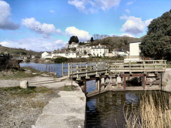
| Interest
Pentewan: The once busy harbour is now cut off from the sea, though the sea lock is still there. There were hopes that the harbour might be re-opened but in 2021 there is still no news. Once Pentewan exported china clay, tin, stone, sand, grain and building stone. Now it is an ever more attractive village with a large holiday park by the beach. There is a good pub, the Ship Inn, and a café. White River: Its real name is the St. Austell River but china clay waste once coloured it white. St. Austell: Cornwall’s largest urban centre and of no interest except for the very centre where you will find the church, narrow higgledy-piggledy streets, a market hall and a multiplicity of pubs, most owned by family owned St. Austell Brewery, whose brewery and visitor centre are close by. Menacuddle Well: A Holy Well and Chapel on the White River. Only just off the trail but you will have to leave on a path left after the storyboards after Tremena Road and then walk a little way along the busy Bugle road. Ruddlemoor: A former china clay village with a strong sense of community. The people have created their own linear Village Green where the clay railway once ran. Wheal Martyn: Superb museum in a former china clay quarry and works. Good exhibitions and displays, impressive plant and machinery and a viewpoint over the working Wheal Martyn quarry. The café is excellent. Useful Information Parking: Free CP in Pentewan village. Free CP at Wheal Martyn China Clay Museum. Intermediate Parking: CP on trail and in lay-by, N of Nansladron, on trail near London Apprentice, and in St. Austell. Trail Links: Cornish Coast Path at Pentewan Sea Lock. The Heligan and Mevagissey Loop, 1.17 miles along this trail. Wheal Martyn to Eden Clay Trail at Wheal Martyn. Ascent: Easy approx. 450 feet from St. Austell by-pass to Wheal Martyn. Highest Point: 490 feet at Wheal Martyn Footing: Mixed track and grassy to St. Austell. Tarmac through St. Austell. Track to Wheal Martyn. Difficulty: Easy going, steepest part is through St. Austell. Refreshments: Ship Inn and two cafés in Pentewan. Many pubs and cafés in centre of St. Austell. Café at Wheal Martyn. Toilets: Pentewan (seasonal). White River Place, St. Austell. Wheal Martyn. Maps: OS 105 Falmouth and Mevagissey. OS 107 St. Austell and Liskeard. |
Heligan Loop - Pentewan, Heligan, Mevagissey - 6½ mls
| Because much of this walk is on a cycle trail, it’s a relatively easy one. It’s also a surprisingly quiet one as cyclists don’t seem to have found the trail extension to Mevagissey yet, and my route, for the first mile, along the Pentewan Valley Trail, mostly avoids the cycle track. Pentewan itself is well worth exploring so I recommend starting and finishing at the redundant sea lock, fascinating in itself. There are just three short stretches of road – a couple of hundred yards in Pentewan, 100 yards on the footway along the St. Austell road, and less than a quarter mile in Mevagissey. The cycleway that you use from the St. Austell road to Mevagissey is well made and good to walk on. It starts with an easy 250 foot climb through the delightful broadleaf woodland - including holm oak and sweet chestnut - of New Road Plantation. At the very top, at around 300 feet, look out for the fascinating barns of Peruppa Farm on your left. Half-a-mile after Peruppa, a track goes right to Heligan Garden. If you feel like making a visit there, it may only be a quarter mile each way but you will need half a day to do the garden justice. Before the track descends more steeply to Mevagissey, there are delightful views over the wooded Heligan Valley below. The Coast Path back to Pentewan is of only moderate difficulty. |  |
| Oliver's Diary - Route Directions - Interest along the way |
|
The Heligan Loop - Oliver's Diary
| I know both Pentewan and Mevagissey quite well, favouring the former by far over the latter. I have also walked all the Clay Trails several times, including Pentewan to Wheal Martyn before its northern section had been completed. It was my late map-making friend Ernie Biddle who told me about the new cycle trail from the Pentewan Valley Trail to Heligan and Mevagissey. So when, in August 2010, I spotted it while walking on the Clay Trail from Pentewan to Wheal Martyn, I decided to return to it for my next walk. As it is a round walk, starting and finishing on the coast, in due course it will become also one of my Coastal Round Walks. For the time being, as it includes a short stretch of Clay Trail, and is waymarked as a ‘Coast and Clay Trail’, I am happy to include it on my Clay Trails page. I enjoyed the stretch to Mevagissey more than I expected. Although it is part of both the Cornish Way and National Cycle Network Route 3, it seems as yet to be little used. All I encountered were dog walkers and one couple on bikes. Reaching Mevagissey, I discovered that I had left my sandwiches on a wall by the St. Austell road. A poor pasty had to suffice for lunch. To my amazement, and pleasure, the sandwiches were still there when I drove by on my way home. |
The Heligan
Loop - Route Directions
This walk
also appears on my Coastal Round Walks page.
| Detailed route
directions include some grid references where it is felt thay might be
helpful, particularly to those carrying GPS as well as map. Click here for full route directions in easily printable .pdf form |
Heligan
Loop - Interest and Information
| Interest along
the way
Pentewan: The once busy harbour is now cut off from the sea, though the sea lock is still there. There were hopes that the harbour might be re-opened but in 2020 nothing has yet happened. Once Pentewan exported china clay, tin, stone, sand, grain and building stone. Now it is an ever more attractive village with a large holiday park by the beach. There is a good pub, the Ship Inn, and a café. Heligan Garden: Rescued from almost a century’s dereliction by Tim Smit of Eden fame, Heligan is now one of the great gardens. Comprising Northern Garden, Ravine Garden, a tropical Jungle, a Lost Valley and a Home Farm, its 90 acres need at least a half-day to do it justice. Mevagissey: Were it just the busy fishing harbour and its immediate surrounds, Mevagissey would be a delightful place. Unfortunately, it has become the worst sort of trippery resort, filled in season with people wandering aimlesly, eating pasties and ice cream from unattractive cafés and take-aways. Try it in Spring or Autumn. Useful Information Parking: Free CP in Pentewan village. Free at Heligan Garden (off trail). Expensive in Mevagissey. Ascent: 250 feet up to bridge near Peruppa Farm. 210 feet out of Mevagissey. 140 feet up from Polstreath. Highest Point: 300 feet near Polruppa Farm. 275 feet on the Coast Path. Steps on Coast Path: 180 up, including flights of 78 and 92. 62 down, including flight of 44. Footing: Well-made cycle trail to Mevagissey. Good footing, mostly on grass, on Coast Path to Pentewan. Difficulty: Easy to moderate to Mevagissey. Moderate on the Coast Path but with two climbs, one steep with steps. Refreshments: Ship Inn and a café in Pentewan. Café at Heligan Garden. Multiple outlets in Mevagissey. Toilets: By Pentewan harbour and on the road into Mevagissey. Map: OS Explorer 105 Falmouth and Mevagissey. |
 |
I first walked this Clay Trail (now called a Coast and Clay Trail) in March 2006. It was difficult to follow then. When I re-walked it in August 2010 it was still difficult. The cycle route part of it is waymarked with blue National Cycle Network signs. Unfortunately, some of these are missing, some are damaged, two are invisible, and one points the wrong way. Which is why I have thought it necessary to include complete route directions below. For the walker it’s a route of three parts. First a mile across dunes and marsh. Then an urban, but off road, mile-and-a-half, mostly following a small river. Finally a rural mile-and-a-half with a sunken track, a long field, a quiet lane, and a track through scrub to Eden. Because much of the route is urban, there are relatively few views, just a glimpse of Clay Country from the lane near Crownhill Farm, though the initial views, south across St. Austell Bay to Little Gribbin and west to the Imerys Par Harbour china clay works, are enjoyable. The grouping of St. Blaise church and the Cornish Arms in St. Blazey is appealing but the church is of relatively little interest inside. On its own this is the least interesting of the Clay Trails. As the trail links at Eden with two other Clay Trails, ideally I would suggest doing it as part of a 10 mile downhill route from Wheal Martyn or Bugle to Par Beach. |
|
|
Route Directions - Interest and Useful Information |
Par Beach to Eden - Route Directions
| Detailed route
directions include some grid references where they may be helpful, particularly
to those carrying GPS as well as map. Click here for full route directions in easily printable .pdf form |
Par
Beach to Eden - Interest and Useful Information
| Interest
Par: Once a busy place when the china clay works were operating at capacity and the harbour was used to ship out the finished product. Now it’s something of a ghost town. The half-mile beach is a good sandy one, dunes and a holiday park behind it. The tide here goes out almost half-a-mile. Marsh Villa Garden: Lovely, privately owned, garden, open Sunday to Wednesday from April to October. Superb herbaceous borders, rockery, roses, pond, bog garden, woodland and more. Teas. Entrance on R, soon after the Royal Inn and almost opposite where you go left down steps into woodland at Par Marsh. St. Blazey: Nothing to commend it, except the attractive grouping of pub and church (is that thirsting after righteousness?) Eden Project: Cornwall’s major tourist attraction and, at the same time, an important ecological venture. Founded by Tim Smit, who also re-vivified Heligan Garden, it needs at least half-a-day for a worthwhile visit. It’s expensive but tends to offer good discounts (including to walkers and cyclists) and incentives. Useful Information Parking: Par Beach (inexpensive). Eden (free). Trail Links: Cornish Coast Path at Par Beach. Saints Way at Par Beach. Wheal Martyn and Bugle Clay Trails at Eden. Ascent: Fairly steep 300 feet from St. Blazey Church to Cornhill Farm. Footing: Mixed track and tarmac to St. Blazey. Paths (sunken and field) and quiet lane on to Eden. Refreshments: Par Beach café, near holiday park entrance.. Cornish Arms in St. Blazey (believed now closed). Café by entry at Eden. Toilets: Par Beach, on lane to holiday park. St. Blazey football ground. Eden. |
Walkers Goss
Moor Link
Goss Moor - Bugle to Eden , 6
miles
 |
After walking the Goss Moor Circular Trail in July 2008, I heard that it was being linked, by a cycle and horse track, with the Bugle to Eden Clay Trail. I investigated the possible route at the time and found only two indications of activity. Along Tregoss Moor there was a short section of track as far as the notorious Iron Bridge and a bridleway from the eastern side of the moor to Pits Mingle was being cleared. In September 2010, having re-walked all the Clay Trails in August, I thought I should take another look. What I found was discouraging; just a couple of new cycle tracks on Tregoss Moor, only one heading the right way. There was still no horse route to bypass the Iron Bridge and the bridleway was overgrown again. So I decided that I would try to create my own off-road walkers route. It proved quite complicated but it worked. My 6 mile route follows cycle tracks from the Tregoss car park to Treranke Cottages and on down the E side of the moor, then grass to the Victoria to Nanpean road. Then it’s SE past Gilley Mill Farm and NE through Trerank to Roche Church. Next I go SE by Roche Rock and Hendra then NE to the Roche to Bugle road. A short bit of road, then behind clay dries back to cross the road and take a former railway and a couple of paths into the centre of Bugle. It may be complex but it works and it's almost all off-road. |
|
|
Route Directions. Interest and Useful Information. |
| I doubt this will ever be completed as a cycle and horse trail. Quite apart from the problem of getting horses past the Iron Bridge on the road from Victoria, I cannot see a way of making enough of it off-road, and the roads are too fast, particularly for horse riders. |
| The Goss
Moor Link - Full Route Directions
Start from the small car park near the railway level crossing at 96094/60982 Detailed route directions include some grid references, helpful particularly to those carrying GPS as well as map. Click here for full route directions in easily printable .pdf form |
The Goss
Moor Link - Interest and Useful Information
Interest
| Roche Rock: Whatever you do, don't miss climbing Roche Rock, for both the Hermitage and the view. This is said to have been the hermitage of one Ogrin who gave shelter to the lovers Tristan and Isolde, escaping the wrath of the latter's husband King Mark. Unfortunately for the legend, the tower was built 900 years too late, in 1409, though in style it seems to be romanesque from a period a couple of hundred years earlier than that. Carbis: Note some modern china clay works here. |
| Parking: Goss Moor, near road from Victoria, close to the railway level crossing at 96094/60982. Trail Links: Clay Trail Bugle to Eden, ½ mile from centre of Bugle. Ascent: 160 feet from start to Tregoss Moor but scarcely noticeable. Footing: Some cycle track and similar track, mostly grassy tracks and field paths, very little road. Refreshments: Rock Inn (food lunch and evening) and Poachers Inn (no food) Roche. Bugle Inn (all day). Toilets: Roche, passed on road towards Bugle. Bugle (behind Rosevears). Map: OS Explorer 106 Newquay and Padstow. |
| Carloggas Down & Great Carclaze Pit | Hensbarrow Downs |
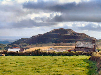
Carloggas Downs & Gt. Carclaze Pit
| Carloggas Downs
When studying clay country on Cornwall's Mapping Website I spotted, just to the east of Stenalees, a viewpoint and car park marked on the top of Carloggas Downs. A short web browse established that this area is part natural downs but mostly restored clay spoil heap. I parked at the bottom, in a car park just east of Viridor, and walked up the well-made but stony track. Views from the 940 foot top are superb, taking in Roughtor and Brown Willy, Kit Hill, Dartmoor, St. Austell Bay and Carluddon Alp. The mapping website shows three cairns on the summit; there may once have been but what exists now is surely part of Imerys' restoration. I walked 2 miles including a return by other paths to Stenalees. Great Carclaze Pit
|
 |
| Both walked at the end of August 2013 |
|
| Looking at Ordnance Survey Explorer sheet 106 for possible short walks in Clay Country I spotted the Open Access land of Hensbarrow Downs to the south of Roche. Craig Weatherhill's Cornovia notes a fairly massive barrow on the top of Hensbarrow Beacon and The Modern Antiquarian notes a handy small car park. I drove there by way of the Old Coach Road from Lanivet to Victoria. I had expected easily to identify Hensbarrrow Beacon from the Old Coach Road but massive modern china clay spoil heaps rise high around it, a great shame as at 1020 feet this is one of the highest natural hills away from Bodmin Moor. From the car park at 99213/57538 a narrow path, wet after rain, leads roughly east through low scrub, following the left-hand wire fence for about 550 yards to reveal the barrow to your right. Views are impressive but do not include Roughtor and Brown Willy which can however be seen from the car park. After I had been to the barrow, described by Craig Weatherhill as being 120 feet in diameter and 18 feet high, I trespassed on Imerys land at Blackpool to get photos of the flooded pit. I then discovered a so-called Blackpool Trail from a small car park at 97559/55268, close to the Old Pound. I shall look at that on another occasion. |  |
| Walked in early September 2013 |
|
|
|
|
|
|
|
|
|
|
|
|
|
|
|
|
|
|
|
|