 |
 |
 |
|
|
|
|
|
|
|
|
To view this page at its best, adjust your screen width and zoom so that text and images align
|
|
|
|
|
|
|
|
| These pages are
now more-or-less complete, bar additions and alterations. They include
the Cornish Coast Path;
45 Round Walks from locations on the coast path; 11 pages of Trails, some entirely inland, several linking the two coasts; and 22 Inland Round Walks (more to come). Bodmin Moor has a general page and there is now a page of 29 Bodmin Moor Walks with fully detailed route directions. |
ON THIS PAGE
|
|
|
|
|
|
|
|
|
|
|
|
|
LINKS TO INDIVIDUAL WALKING PAGES
|
|
|
|
|
|
CORNWALL REVIEWS
INDEX and SITE CONTENTS
|
|
|
|
|
|
|
|
|
|
|
|
|
|
|
|
|
|
|
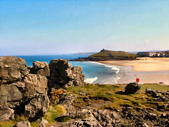
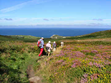
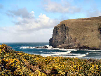
| Britain's longest official trail is the South West Coast Path, from Minehead on the Bristol Channel to Poole on the English Channel - round Somerset, Devon, Cornwall, Devon again and Dorset. Total length is said to be 630 miles but I think it's more like 700. Of this, the greatest part is in Cornwall where estimates vary from 260 to 320 miles. My own calculation, having walked every Cornish inch of it with a GPS, is that, if you follow the path faithfully and walk out to all the accessible headlands, and down to all the accessible coves, you will cover 312 GPS miles from Welcombe Mouth just over the North Devon border - no parking at Marsland Mouth on the border - to Cremyll Ferry on Plymouth Sound. Characteristics vary greatly along the way. The highest cliffs are near Countisbury, rising at Butter Hill to almost 1000 feet. Along the north there is generally less vegetation and, while many small streams tumble over cliffs, only one serious river, the Camel, intrudes. Between Newquay and Hayle there are 'towans', vast sand dunes where you may have to walk on the beach. The West Penwith peninsula, that mysterious land beyond St. Ives and Penzance, contains the most difficult walking with many steep ascents and much rock-scrambling. The south coast is more wooded and the rivers have drowned valley estuaries - Helford, Fal, Fowey, Looe and finally the great Tamar on the Devon boundary. |
 |
| I buy my
walking gear from Country Wise of Wadebridge
Now go to my Cornish Coast Path page |
Fascinating St. Enodoc church out of shot to right |
 |
I really first discovered the Cornish Coast as a result of doing round walks. In my earliest Cornish walking days it never occurred to me that I could devise my own walks. I had been accustomed to walking in country accessible from London, where Jane and I had lived previously. I was not really a walker but Jane joined the local Ramblers who organised bus groups to walk in Berkshire, the Cotswolds and Buckinghamshire. In due course she persuaded me to join, too. When we tired of the Ramblers regimentation, and decided to do our own walking, that meant using the car to do round walks. So we bought a number of round-walk books and worked from them. We moved to Cornwall in 2002, I as incomer, Jane as returnee, and bought several books of round walks. Those we chose were nearly all based on the coast and that was my real introduction to the Cornish Coast Path. Having now walked the Coast Path twice, first doing mostly round walks, then in 2009/2010 doing all linear walks, I then set about round coast walks again, this time with the intention of producing a series of Best Coastal Round Walks. This project is more-or-less complete with 46 walks to date. They contain full walk directions, description, diary and interest. I hope I may add a few more from time to time. |
|
|
Now go to my Best Coastal Round Walks page |
| This page and its several sub-pages cover a number of areas and subjects. The introductory page covers Cornwall's countryside in a general manner and links to sub-pages on the following subjects. Rivers and their Valleys covers all Cornwall's rivers of significance and includes several valleys where there are little more than streams but plenty of scenic or other interest. West Penwith is mostly about the high moorland and the area's antiquities; it includes detailed direction for my favourite West Penwith walk, one that covers many of the finest antiquities, such as the Nine Maidens stones and Bosporthennis Fogou. A Miscellaneous Inland page includes all Cornwall's great estates, such as Lanhydrock, Mount Edgecumbe and Trelissick, and has several suggestions for interesting and enjoyable walks. It also includes features on Clay Country and Slate Country, several major hills - notably Carn Brea, Carn Marth and Kit Hill - and a few other miscellaneous entries such as the trail around Goss Moor, the trail through Tehidy Country Park at Illogan and a walk over Hamatethy Down near St. Breward. There are also links to my Bodmin Moor page, to my Inland Trails page and to a new page on Inland Round Walks. This latter is a new project and, in May 2015, as yet boasts only 22 walks; I hope more will come. |  |
| Now go to my Countryside page |
|
| If you prefer walking where your route is predetermined and clear, but get bored with coastal walking, which is what many assume is the only kind of Cornish walking, do as I do sometimes and try one of the many trails. There is a tremendous variety. There are four coast-to-coast trails:: the Mining Trails Coast-to-Coast, St. Michael's Way, the Saints Way and the Smugglers Way. There are four other Mining Trails: the Redruth and Chacewater, the Portreath Branchline, the Great Flat Lode and the short Tresavean Trail - plus one of my own devising, where Cornwall Council's fnancing ran out, the Tolgus Trail. There are the Clay Trails, 33 miles of multi-use trails in Clay Country north of St. Austell. There are three very different circular trails, Mark Camp's 60 mile Copper Trail around Bodmin Moor, the Penwith Round, a circuit of most of West Penwith's antiquities, and the Zennor Churchway/Tinners Way in West Penwith. The best known trail of all, the famed Camel Trail, is on a former railway track from Padstow to the edge of Bodmin Moor. And finally there is the daddy of them all, the Land's End Trail, an 142 mile inland route from Land's End to Tavistock in Devon, with an extension to Avebury in Wiltshire. I have walked all of these and am now re-walking many of them, in company with my Garmin GPS and Olympus digital voice recorder, revising my previous data. |
 |
| Now go to my Cornwall's Trails page |
|
 |
As a change from following trails such as the Cornish Coast Path, the Mining Trails and the many other trails that criss cross Cornwall, many of them fairly busy in the summer months, I like to get away from it all. The best way of doing that is to get out onto the high moorland: Bodmin Moor and the moors of West Penwith. Here I can often walk all day and see no life other than grazing cattle, ponies and sheep and circling hawks and buzzards. There are a few moorland walks in walk books, particularly Mark Camp's excellent Bodmin Moor series, but I prefer to devise my own. Over the years I have notched up more than 30 walks of my own devising, most of them in search of antiquities. Now, in addition to my general Bodmin Moor page, I have a separate page devoted to fully detailed round walks on Bodmin Moor. I have also done a lot of walking on the moors of West Penwith. Here, thanks to the lack of grazing of the moors, going can be more difficult than on Bodmin Moor. I have done half-a-dozen or so round walks in these parts and hope to create a separate page for these. Finally, I have devised a couple of dozen other inland round walks and have tried to put these in some sort of order on their own Countryside pages so that others may be able to follow them. |
|
|
Now go to my Bodmin Moor page or to Bodmin Moor Walks |
Online Mapping - Cornwall Council's Mapping Website
|
The ''Right to Roam' legislation - long agitated for by the Ramblers Association, initially opposed by many landowners and finally introduced in 2000 - has resulted in vast areas of land all over England, Scotland, Wales and Cornwall being opened up to the general public. Essentially these rights are for walkers only - suits me. I used to find the Countryside Agency's Open Access website an immense help in my Cornwall moorland walking, not just on Bodmin Moor but also in West Penwith. Unfortunately the site, now under Natural England, has been messed around with and navigation is far too complicated to be of any serious help to walkers. As a result, it is no longer worth, as a walker, using it in its current form. .Fortunately, Cornwall Council has an excellent mapping web site, which I find better than the Open Access site ever was. It is easy to use, shows Open Access land, rights of way, path numbers should you wish to report problems, and is zoomable up to large scale. A word of warning on Open Access land. I soon discovered that this may not always be quite as straightforward as that. I have encountered barbed wire fences, locked gates and even one gate on Bodmin Moor, leading to access land, that has a 'no walkers' sign on it. And, in West Penwith, where moorland is lower, I have found impenetrable furze or bramble so don't expect it always to be easy. |
|
|
OS Explorer maps show Open Access land as yellow |
Ordnance Survey Maps - The 1:25000 Explorer Series
 |
My earliest walking
was done with Jane with the Independent Ramblers, based in Ealing.
With them we learned to love the Chilterns and the Cotswolds. But
we soon graduated to our own independent walks, first from walk books,
later of our own devising. The Ordnance Survey 1:25000 series became
our bible. The current 2005 Explorer series still is my bible (to
a degree) particularly as it now shows Open Access land. But, as
with the Bible, you learn not to believe every word. I use OS maps,
GPS and compass on most walks, especially on Bodmin Moor and on the moors
of West Penwith. But I have lost some trust in OS.
Since completing Mark Camp's Copper Trail during winter 2006, I have been walking routes of my own devising on Bodmin Moor and have been horrified to discover just how unreliable the Ordnance Survey can be. A couple of walks in December 2006 proved that. A path shown from Butterstor to Garrow simply does not exist yet OS quite fails to show a well waymarked path from Brown Willy to Garrow (and on to King Arthur's Hall). Below Garrow the OS fails to mark a footbridge over the De Lank River. It also fails to show a footbridge and clapper bridge that cross the river at the southern foot of Garrow Tor. Elsewhere I have found marsh that isn't shown, probably because it is not low-lying. So be advised, take your map, your compass and your GPS and expect the unexpected. |
|
|
Don't expect all antiquities to be marked either |
Walking Trail Books - Our Preferred Walk Guides
 |
CIRCULAR WALK GUIDES
Jarrold Pathfinder Cornwall Walks: 28 walks, most include coast, distances 4 to 11 miles. Good large scale Ordnance Survey maps, good descriptions and information. AA 50 Walks in Cornwall: Mostly coast but includes about 10 inland, 3 to 8 miles. Good descriptions and information, sketch maps could be much better, good on severity. Classic Walks in Cornwall: 2 volumes, each of 60 walks, all but 5 include coast, 3 to 6 miles. Good descriptions and information, poor sketch maps, good on severity. Circular Coast Walks Cornwall: by Moor, Dale and Mountain Press. 36 walks, 3 to 10 miles. Good information, routes not too clear, sketch maps. Ramblers Association Cornwall: has published 14 volumes, each of 6 or so walks. Bodmin Moor Walks (and much more): The excellent IwalkCornwall site TRAIL GUIDES
|
|
|
| WALKABOUT WEST
Mark Camp offers guided walks generally in Cornwall and especially on Bodmin
Moor. Mark is one of the experts on Bodmin Moor: its
history, its antiquities and its industries - tin and copper mining, granite
quarrying aned china clay production. Mark has also published a number
of books about Bodmin Moor - three books of Short Walks, a new (March 2009)
Introductory Guide and a guide to the trail that he devised, the 60 mile
Copper Trail around the moor.. Links: The
Best of Bodmin Moor Books - The
Copper Trail - Juhn Alden's IWalkCornwall - Mark's
WalkaboutWest
ENCOUNTER CORNWALL This was new to me when I spotted it in April 2009. I had a good browse of their web site and think it well worth bringing to your attention. Encounter Cornwall organises walking tours - self-guided and supported - and has a recommended accommodation list. Tours, varying from 2 to 10 days, include the Coast Path, The Copper Trail, three Coast-to-Coast trails (Saints Way, St. Michaels Way and Smugglers Way) and some one centre breaks. Their programme also covers supported cycle tours with bike hire and guided kayaking trips on the Fowey River. Web site Encounter Cornwall |
|
| I am sure there are many others but I don't know them |
|
 |
| I had no idea that such an organisation existed until I heard from Steve, Cornwall Rolling Ramblers chairperson, who had seen my web site and was interested in any information I might have on possible rolling rambles. CRR is a group of disabled people who love the countryside and use their small-wheel mobility scooters for organised rambles. They meet regularly between April and October and their rambles cover all of Cornwall with occasional forays further afield to routes like the Granite Way in Devon. Thay are fortunate that, in Cornwall, there are many ready made trails - the Mining Trails and Clay Trails - which were designed as multi-use. Several of these connect with the Cornish Way cycleway, part of the National Network of cycle routes. Cornwall Rolling Ramblers are actively seeking members. Do take a look at their web site for more information. Steve was formerly a diver and climber; as a diver, he created the Diving Cornwall web site. |
Links - to other Cornwall Walking Sites
| Walking in Cornwall | Part of John Harris's comprehensive Walking in England site. Many walk descriptions with maps, printable as Pdf files. |
| iWalk Cornwall | John Alden's comprehensive site has around 200 round walks of varying length, quality and interest |
| Best of Bodmin Moor | History, landscape and fauna of the Moor. Books by Mark Camp on the Moor, the Copper Trail, and three Walk Guides |
| Mining Trails | Download the latest printable .pdf brochure about Cornwall's mining heritage and multi-user Mining Trails |
| Engine House Trail |
Combines Great Flat Lode, Portreath Branchline, Redruth & Chacewater and part of Coast-to-Coast |
| Clay Trails | China clay history and description of multi-user Clay Trails in the St. Austell area |
| Visit Cornwall | Official Cornwall Tourist Board site includes walking tour operators and information on other outdoor activities |
| Walkaboutwest | Mark Camp, Blue Badge guide and Bodmin Moor expert offers guided walks on Bodmin Moor and elsewhere |
| South West Coast Path | Official site of the South West Coast Path Association. A lot of pages of information, short walks and long walks |
| Walk 4 Life | Walk England's site has moderate and very short walks, with maps, in Cornwall, as part of a nationwide walk campaign |
| Long Distance Walkers | The LDWA's site lists and links hundred of trails, including the Land's End Trail and Tinners Way/Zennor Churchway |
| Walking World | 5500 walks in Britain include many in Cornwall but you need paid membership to download them |
| National Trust | The NT's walk pages include about 40 on NT property in Cornwall, mostly very short, longest is about 7 miles |
| The AA | The AA has a number of Cornish Walks but site navigation is poor - and the same can be said for most of the walks |
|
|
|
|
|
|
|
|
|
|
|
|
|
|
|
|
|
|
|