
|
The LDWA, using digital mapping, makes the distance 303 miles. I prefer my calculation. |
|
|
|
|
|
|
|
|
Text and images should align. To view this page at its best, adjust your zoom to full screen width
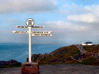
| The Land's End Trail was conceived by Hugh Miners and fully researched by a group of Cornish Ramblers - Robert Wicks, Robert Preston and Robin Menneer. They published it as Land's End to Avebury in the 1990s. In 2009 Robert Preston and Oliver Howes re-walked the trail; as a result some minor amendments were made to the route. Olivers Cornwall Land's End Trail pages include Route Directions and Maps. |
On this page
|
|
|
|
|
Links to Detailed Route Directions and Sketch Map
|
|
|
|
External Links
|
|
|
|
|
|
|
|
|
| Route directions are
in PDF form and you will need Adobe Reader to download them. The
Cornish Section consists of 13 stages from Land's End at Cornwall's extremity
to Tavistock in Devon. The Tavistock to Avebury Section consists
of 14 stages. Each of these sections has two pages of introduction
and a page for each stage with full route directions and a sketch map.
The second introductory page for each section has a Glossary of Terms,
an explanation of abbreviations used and a list of Ordnance Survey Explorer
maps needed. For each stage we have tried to include availability
of parking at each end and opportunites for refreshments along the way.
Below is a more complete list of abbreviations used in the route files. |
Abbreviations used in the PDF Route Files
| Abbreviations are
not always used. Where they are it is essentially for reason of space.
GENERAL
|
Robert's Ramble
- Robert Preston's Fundraising Epic
| In April 2009 Robert Preston, one of the original Land's End Trail researchers, walked from Oakhampton - just off the trail - to Swindon, a few miles beyond Avebury. Robert is a verger at Truro Cathedral and undertook this little jaunt to raise funds for the Cathedral's Central Tower Appeal. It was quite a walk, around 200 miles in 14 days and Robert raised more than £4000 for the appeal. Congratulations, Robert, from all the LET Group. Double congratulations, really, because Robert was also checking out our route directions which had not been done recently. The results of Robert's sterling efforts can now be seen in the updating of our Tavistock to Avebury page - the revised directions in the PDF file of Route Directions. Thanks to Robert's trek, the complete route from Land's End to Avebury is now up on the web. |
The Land's End Trail
- Some Advice and Suggestions for Walkers
We hope this analysis of the
nature of the LET will be helpful to those who plan to walk it
| DIFFICULTY
We rate the Land's End Trail as fairly challenging. It's not that
it involves any vast climbs, rather that, whatever time of year you choose,
you will encounter awkward terrain and difficult conditions. Just
what the doctor ordered for those who enjoy a serious challenge.
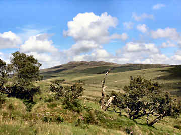
LANDSCAPES We have deliberately devised the LET to encompass as much landscape variety as possible. We have looked for the high ground wherever possible, so you will encounter high wild moors in Cornwall, Devon and the western part of Somerset. You will also encounter some lovely river valleys like the Camel, Fowey and Tamar in Cornwall, and the Taw, Mole and Barle in Devon. Then there are the different delights of the Somerset levels and the close-cropped chalk downs of Wiltshire. TERRAIN The LET climbs to almost 1400 feet at Brown Willy on Bodmin Moor in Cornwall, to 2000 feet at Hangingstone Hill on Dartmoor in Devon; on Exmoor it reaches around 1200 feet and on the Wiltshire Downs around 1000 feet. None of these climbs are particularly steep, though some are rocky. Views can be spectacular. You will encounter blanket bog on Bodmin Moor and Dartmoor; this should be negotiated with care. Elsewhere there is easy walking on the occasional cycle trail, on bridleways, byways, lanes, quiet country roads and paths over pasture land. CONDITIONS You might expect that going would be easiest in summer. The summers of 2007, 2008 and 2009 suggest that it may be otherwise. In these summers we have met with seas of mud here and there. And summer can mean that overly lush growth can obscure some of the less used paths, particularly in Cornwall. From October to April going may well be easier. STAGE LENGTHS These vary from 7 miles from St. Erth to Leedstown in Cornwall to 22 if you choose the High Dartmoor crossing in Devon. In places, short stages may be adjacent and experienced long distance walkers may elect to combine 2 or even 3 stages as one. WAYMARKING The LET does not yet have official recognition so it is not self-waymarked. However, the majority of paths and tracks have local footpath signs and waymarks. In the text, we specify where these occur. Where waymarking is that of another, local or national, trail we specify that. There are places where local councils have failed to to fulfil their obligation to provide signage and waymarks. When this occurs, we give very specific directions. In the occasional place you will find a chevron waymark; this is an LET sign. OTHER TRAILS Along the way the LET crosses or uses parts of recognised self-waymarked trails, local or national. We have tried to mention all of these, particularly where, as with the West Devon Way and the Tarka Trail, the LET follows them for a substantial distance. EQUIPMENT Experienced long distance walkers and backpackers will need no advice on how to equip themselves. The less experienced may like to follow our suggestions. Sturdy boots and weatherproof gear are essential and gaiters can prove useful when encountering mud or barley. The appropriate Ordnance Survey Explorer 1:25000 scale maps are essential as the text mentions many intermediate points not found on smaller scale maps. We often mention compass direction so do carry a compass. And, if you opt for the High Dartmoor crossing, you might find a simple GPS useful. On some of the more difficult bits of terrain - rocky hillside and blanket bog - a pole or two may be useful. MAPS In the introduction to both the Cornish Section and the Tavistock to Avebury Section of the LET we list all the OS Explorer maps that cover the trail. Even more detailed maps are available online for Cornwall, Devon and Somerset but, sadly, not for Wiltshire. Here are links: Cornwall -Click here Devon - https://new.devon.gov.uk/prow Navigation to map is complicated; patience will get you there Somerset - Definitive map apparently not available online. Open Access - Click here for open access maps. The process seems unnecessarily complicated |
Hugh Miners - the man who conceived The Land's End Trail
 |
Hugh Miners, who died on 27th February 2009, aged 94, was a man of many talents and interests and not one to shirk controversy. Born in Wadebridge in 1915, his family moved to Penzance where he was educated at what is now the West Cornwall School. By profession an officer with HM Customs and Excise, he worked in Bristol, London and Nigeria. In retirement he travelled the world with his wife but eventually settled back in Cornwall, living first in Pendeen and latterly in Penzance. Cornwall and Cornishness were his real life’s interests. At a time when Kernewek (the ancient Cornish language) was going through its first re-invention he learned it and even taught it in London. He was, as Den Toll, a Grand Bard of the Cornish Gorseth from 1982 to 1985 but resigned, apparently amidst some controversy. He loved Cornwall not just for its independent Celtic character but especially for its landscape and history. As well as writing about these, he loved walking and traced the Tinners Way – following the high ground from Cape Cornwall to St. Ives. And it was he who in 1984 conceived the idea of the Land’s End Trail and first started researching it. He was also a talented cricketer, described by Michael Williams as ‘the doyen of Cornish cricketers’ and even for a while played professionally in the Yorkshire League. His publications included The History of the Gorseth Kernow, The Story of the Bristol Cornish and a poem, Half a League Onwards, for the Cornwall Footpaths Preservation Association. In his retirement travels he helped found the Australian Federation of Cornish Associations. In his last years he was active in the Penzance Living Streets Project. We of the LET Group all owe Hugh a huge debt for setting us off on a fascinating project that, after more than two decades, is now approaching full fruition with the web publication of the complete route. |
|
|
|