

| Oliver's Cornwall | The Penwith Round | A circular trail
in West Penwith |
|
|
|
|
|
|
|
|
To view this page at its best,
adjust your screen width and zoom so that text and images align Penwith Round - 32½
mile trail from Mousehole to Cape Cornwall and back to Penzance
Devised
by Alexandra Pratt and first published in The Celtic Way by Val
Sanders Evans
To walk the whole way, incl. from Trencrom Hill to St. Michael's Mount
to Mousehole, it is 44½ miles
| INTRODUCTION | MAPPING WEBSITE | ORDNANCE SURVEY MAPS | THE STAGES |
|
|
|
|
|
|
|
|
|
|
|
|
|
|
|
|
|
|
|
|
|
|
| The Trail directions have Treen to Crows-an-Wra as one stage. I split it into two round walks so, where the official trail has only five stages between Mousehole and Penzance, I descibe six. If you walk the full 44½ miles, including stages from Trencrom Hill to St. Michael's Mount and from the Mount to Mousehole, you will have seven or eight stages. The PDF file of directions and interest originally appeared in Val Saunders Evans out-of-print Celtic Way. I found it on the web but, soon after I downloaded it, it disappeared. I have been unable to locate either Val or Alexandra Pratt, author of the Penwith Round. I hope they will not mind my small revisions. |
The Stages from Mousehole to Cape Cornwall and back to Penzance
|
|
|
|
|
|
Introduction
 |
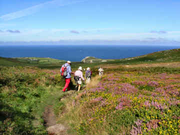
During 2007 I first walked the Land's End Trail - from east to west. I had found it in Val Saunders Evans' The Celtic Way and, as the directions there end with a stage from Trencom Hill to St. Michael's Mount, that was what I walked. I then started on the Penwith Round, also in The Celtic Way, in March 2008. I could, I suppose, have walked from St. Michael's Mount to Mousehole but this seemed pointless. I had done it before when walking the Coast Path and, frankly, it is the most boring part of it. Happily, the purpose of the Penwith Round, unlike the Land's End Trail, is not so much to get you from A to B as to educate and entertain you along the way. There is a full route description but there is also a great deal of antiquarian and historical description as the Round wanders from one prehistoric site to another. Ancient highlights along the way include the Merry Maidens and Pipers, Treryn Dinas cliff castle, Boscawen-ûn circle, the crosses and holy well at Sancreed, Carn Euny iron age village, Chapel Carn Brea, Bollowal Barrow, Chun Castle and Quoit, Bodrifty iron age village and Mulfra Quoit. Buses were useful but I had to split the Treen to Crows-an-Wra section in two. My reports do not include route directions - only comments - but to access full details, including information on history and antiquities, click on the link below. |
|
|
DOWNLOAD FULL PDF TRAIL ROUTE DESCRIPTION |
Online Mapping - Cornwall Council's Mapping Website
 |
'Right to Roam' legislation, the Countryside and Rights of Way Act, - long agitated for by the Ramblers Association, and initially opposed by many landowners - has resulted in vast areas of land all over England, Scotland, Wales and Cornwall being opened up to the general public. Essentially these rights are for walkers only - suits me. I used to find the Countryside Agency's Open Access website an immense help in my Cornwall moorland walking, not just on Bodmin Moor but also in West Penwith. Unfortunately the site, now Natural England, has been messed around with and although the maximum scale is acceptable, maps are too small and navigation is quite awkward. As a result, it is no longer worth, as a walker, using it in its current CRoW Access form. Fortunately, Cornwall Council has an excellent mapping web site, which I find better than the Open Access site ever was. It is easy to use, shows Open Access land, rights of way, cycle trails, path numbers should you wish to report problems, and is zoomable up to large scale. A word of warning on Open Access land. I soon discovered that this may not be quite as straightforward as that. I have encountered barbed wire fences, locked gates and even one gate on Bodmin Moor, leading to access land, that has a 'no walkers' sign on it. And, in West Penwith, where moorland is lower, I have found impenetrable furze and bramble. So don't expect it always to be easy. |
|
|
OS Explorer maps now show Open Access land as yellow |
Ordnance
Survey Maps - The 1:25000 Landranger Series
 |
My earliest walking was done with Jane with the Independent Ramblers, based in Ealing. With them we learned to love the Chilterns and the Cotswolds. But we soon graduated to our own independent walks, first from walk books, later of our own devising. The Ordnance Survey 1:25000 series became our bible. The current 2005 Explorer series still is my bible (to a degree) particularly as it now shows Open Access land. But, as with the Bible, you learn not to believe every word. I use OS maps, GPS and compass on most walks, especially on Bodmin Moor and on the moors of West Penwith. But I have lost some trust in OS. Since completing Mark Camp's Copper Trail during winter 2006, I have been walking routes of my own devising on Bodmin Moor and have been horrified to discover just how unreliable the Ordnance Survey can be. A couple of walks in December 2006 proved that. A path shown from Butterstor to Garrow simply does not exist yet OS quite fails to show a well waymarked path from Brown Willy to Garrow (and on to King Arthur's Hall). Below Garrow the OS fails to mark a footbridge over the De Lank River. It also fails to show a footbridge and clapper bridge that cross the river at the southern foot of Garrow Tor. Elsewhere I have found marsh that isn't shown, probably because it is not low-lying. So be advised, take your map, take your compass, take your GPS and expect the unexpected. |
|
|
Don't expect all antiquities to be marked either |
 |
I had good company for the first section of the Penwith Round in March 2008. My sister Mary was staying with us for a few days. We visited newly opened Port Eliot House, walked together on the Redruth and Chacewater Trail, walked at Godrevy with Jane and did this first part of the Penwith Round. In order to be able to use a bus one way, we did an extra couple of miles. We parked at Treen, caught the number 1 bus to Newlyn and set off from there to start our walk proper in Mousehole. Directions worked well except, oddly, at the beginning. At the top of the steep (unsigned) path from the Methodist chapel, you now turn right on the lane and left into the field through a new gate. The inland part was easy going, the coast part has three stiff climbs. I am afraid the info about Castallack Round may be a bit haywire; I think it's the hexagonal field on the right just before the wooden gate. The standing stone is hidden by brambles some way further on. Whilst on your way, do take time to explore the Merry Maidens and the several nearby standing stones and Cornish crosses, charming Penberth Cove and the very impressive Treryn Dinas cliff castle. On arrival in Treen, the café by the car park, though not really open, made us welcome tea and coffee; a few days later I was back for a superb bacon bap and cafétiere. |
|
|
The complete trail is on OS102 Land's End sheet |
Treen to Bosacawen-ûn Stone Circle - 5 miles (9 miles round)
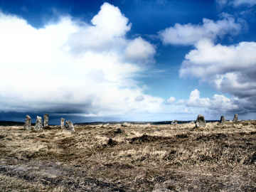
| I had hoped that the number 1 or 1A bus might enable me to do this walk as Treen to Crows-an-Wra. One bus stops at one, the other at the other, but neither at both. So I have split this section and will next do Boscawen-ûn to Crows-an-Wra. Again I parked at Treen, useful for refreshments. The Round's directions might benefit from a little amendment on this section. Leaving Treen, don't use the road but follow the unsigned path along the side of the car park to cross fields (look out for an unmarked standing stone to your left) and descend through woods to Penberth Cove, a delightful spot worth lingering at. On the way to St. Buryan you can cut out some road; turn right immediately after Pendrea to cross fields most of the way. The path out of St. Buryan (no spire to the church tower) can be difficult to spot; a narrow gap between houses. Then finally, at Changwens Farm follow their 'Nature Trail' sign to cross a couple of fields to the track to Boscawen-ûn circle. I was delighted to, at last, get a better photo of the stones. I returned by Higher Leah Farm, field paths to St. Buryan and, for speed, the road back to Treen, passing a succesion of primitive direction stones. Back at Treen I was in time for good fresh coffee and superb chocolate cake at the café by the car park. |  |
| In this photo you
don't see the angle of the central stone |
|
Boscawen-ûn to Crows-an-Wra - 6 miles including detours (7 miles round)
 |
This proved to be an easy section to do at the end of March 2008, paths were all fairly clear and route directions were easy to follow; only a total of 20 stiles impeded progress at all. I parked with no difficulty on the A30 not far from Bosacawen-ûn stone circle, where there is room for 6 cars. I do have a couple of suggestions to add to the interest - and the distance - along the way. The first is close to the start; instead of the lane to Tregonebris Farm and the path through Anjarden, I chose to stay on the Penzance road for another half-mile so as to visit the Blind Fiddler, an impressive 10 foot tall menhir, then over fields past Leslew and Trevorian farms to Sancreed. I lingered in Sancreed for the churchyard crosses and Chapel Downs Holy Well. After Sancreed Beacon I detoured again to visit Caer Bran hill fort, worth seeing now PAROW has cleared some of the site. At Brane I encountered the farmer who happily gave his permission to visit his chanbered cairn, well worth it. At Crows-an-Wra, do linger to see the Cornish cross on the green triangle and to admire the handsome direction stone next to it. From there it was just an easy level mile back to the car, passing Trevorgans cross on the way. An enjoyable walk, chock full of antiquarian interest. |
|
|
PAROW is the Penwith Access and Rights of Way group |
Crows-an-Wra
to Cape Cornwall - 6 miles (12 miles round)
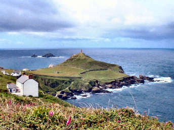
| I decided to kill two birds with one stone on this April 2008 section. One bird was to make a round walk of it (no buses), the other was to include the first 1½ miles of the next section to Penzance - to make that bit easier. So I parked in the NT Cape Cornwall car park and set off first down to the Kenidjack Valley for more mine photos. Then I followed the Penzance route as far as the St. Ives road before heading into St. Just (part road, part fields). Next I followed an old path through St. Just to come out at Bosavern and follow the road to Chapel Carn Brea. I didn't bother with the bit of road to Crows-an-Wra and back (boring) but headed up Chapel Carn Brea to start the trail route to Cape Cornwall. Trail directions are quite clear but the way down off Chapel Carn Brea is a bit confusing; just bear in mind that you are headed for white-painted Kerrow. You might also have a small problem at Brea Farm, where the footpath sign is missing; turn right just before the last barn. The last 3 miles from Nanjulian Cove are on some of the toughest coast path, constant up and down on very rocky paths. But well worth it for the superb views. Intesest along the way includes the cairns on Chapel Carn Brea, mine remains at Nanjulian and Porth Nanven (and the rocks at the latter) and amazing Bollowal Barrow at Carn Gluze. |  |
| Welcome refreshments Cape Cornwall golf club; & in St. Just |
|
Cape
Cornwall to Penzance - 11 miles it says (I reckon
it's nearer 14)
 |
My final section of the Penwith Round was another terrific walk, although I think the trail directions seriously underestimate the distance. By map wheel it is over 12 miles so I reckon it may be 14. Having continued up the Kenidjack Valley at the end of the previous section, this time I started from St. Just and picked up the trail at Truthwall Lane, having taken the 17 bus from Penzance and picked up a superb lunch pasty from the butcher in St. Just. Magnificent antiquities again - Tregeseal Stone Circle (the site recently cleared); Chûn Quoit and Castle; Bosullow Trehyllys, Bodrifty and Mulfra Vean iron age settlements; and Men-an-Tol, Men Scryfa, the Nine Maidens and Mulfra Quoit. And, delightfully, much of the time you can see your next landmark from the top of each hill. No serious problems with the route, unless you count the furze and brambles on Nine Maidens Common. One minor problem at Polkinghorne; no FP sign but turn right off the lane above the last house on the right. I did, however, make one unintentional variation. Leaving the road after New Mill (attractive Old Post Office) I found myself in beech and bluebell woods by the Trevaylor stream. The woods were so pleasant that I stayed in them and came up at Polkinghorne, missing out Boscobba. A great walk and a great finish to a very enjoyable Penwith Round. |
|
|
Many of the antiquities on this stage on the Land's End Trail |
|
|
|
|
|
|
|
|
|
|
|
|
|
|
|
|
|
|
|