|
Robert's Land's End Trail - a commentary |
|
|
|
|
|
|
|
|
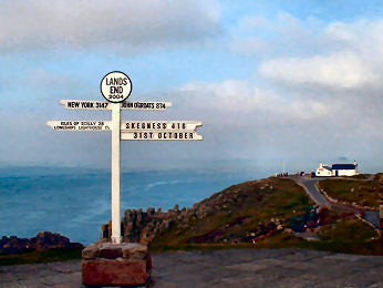
| The Land's End Trail was originally conceived by Hugh Miners and was researched by a group of Cornish Ramblers - Robert Wicks, Robert Preston and Robin Menneer. They researched and published the route from Land's End to Avebury in the early nineties. Route details from Land's End to Tavistock have been more-or-less finalised. To see them click on Cornish Section below. The draft details of the LET from Tavistock to Avebury are, for the time being, available (£5 post paid) from Robert Preston (Tel: (0) 1 872 262 334). Robert Preston has been re-walking and updating the Trail directions from Tavistock to Avebury. This page will be Robert's commentary on the route, stage by stage, with a characterising image for each stage. A separate page will describe, with images, the interest highlights along the way, shown in the Trail text in bold italics. Better maps are under development. In due course the complete LET will appear on these pages as Land's End to Avebury in both directions. FOR CONVENIENCE, WE SUGGEST OPENING THE PDF FILE IN A SEPARATE TAB. |
|
|
|
Tavistock to Avebury |
Index to Commentary |
Things to look out for along the trail |
The route from Land's End to Tavistock |
Return to LET Home |
| Oliver's Cornwall | Ramblers Association | Long Distance Walkers Association | Backpackers Club | Contact LET Group |
|
|
|
Index to the stages from Tavistock to Avebury
| Stage
14
Tavistock to Lydford |
Stage
15
Lydford to Belstone |
Stage
14/15
Tavisrock to Lanehead |
Stage
14/15
The Dartmoor Route |
Stage
16
Belstone to Sampford Courtenay |
| Stage
17
Sampford Courtenay to Chulmleigh |
Stage
18
Chulmleigh to South Molton |
Stage
19
South Molton to Dulverton |
Stage
20
Dulverton to Wiveliscombe |
| Stage
21
Wiveliscombe to Bishop's Lydeard |
Stage 14 - Tavistock to Lydford - 10 miles
 |
Like the following stage, from Lydford to Belstone, this is easy walking using existing established trails. Sufficiently easy that you may consider adding stages 14 and 15 together to make one long stage. Or, if you are an enthusiastic moorland walker, you may choose to take the Dartmoor route, described below. This stage uses the West Devon Way, waymarked but not always obviously. After an inevitable bit of road walking to get out of Tavistock, the trail takes the Old Tavistock Road, now little more than a track in places, to Harford Bridge before getting onto field paths to Mary Tavy (attractive church). A little more quiet roiad then its across West Blackdown (or up over Gibbet Hill) on clear wide horse tracks to join the quiet road to Lydford at the former Lydford Station. It's a pity that the Granite Way doesn't extend south to Lydford Station; that would save the road walking. Already the feeling is quite different from Cornwall, more hedgerows than Cornish hedges and stiles are mostly wooden. I enjoyed the walk which I did by parking (free) in Lydford and taking the Beacon bus to Tavistock. Lydford is an attractive village, worth lingering in for its church, castle and friendly Castle Inn and, of course, the famed National Trust Lydford Gorge. The car park in Lydford is right opposite the Castle Inn. |
|
|
Stages 14 & 15 are Oliver's Commentary, thereafter it is all Robert's |
Stage 15 - Lydford to Belstone - 13 miles
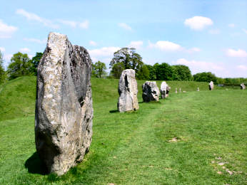
| This stage was a delight with a wide variety of countryside and using several trails. It uses the West Devon Way as far as Melson Bridge, continues on the Granite Way (former railway line) to Okehampton Station, uses the Devonshire Heartland Way to Fatherford Bridge and then joins the Tarka Trail to Belstone. As with Stage 14, it is easy going all the way. From Lydford village you are soon on a bridle path, as they call bridleways in Devon that takes you onto an edge of Dartmoor at Fernworthy Common. Then field paths lead to Sourton where the Highwayman makes an good and entertaining refreshment stop. Now it's on to the open Dartmoor moorland of Sourton Common. Between Meldon Bridge and Okehampton Station you may need to look out for cyclists on the Granite Way. Meldon and Okehampton stations are the termini of the Dartmoor Pony Railway and I can strongly recommend the Station Buffet at Okehampton. There is then a short stretch of bridle path through woodland, on the Devonshire Heartland Way, leading to my favourite part of this stage, first following the Tarka Trail through woods along the East Okement River then, after crossing the river, over Belstone Common, passing Nine Stones Cairn Circle, to the charming village of Belstone. I can't report on the Tors Inn there (it was closed) but can recommend the teas at The Barton. |  |
| Stages 14 and 15 are Oliver's Commentary, thereafter it is all Robert's |
|
Stage 14/15 - Tavistock to Belstone - The Route to Lanehead - 8 miles
 |
You might expect that all the scenic interest on this long stage would begin once you get to Lanehead and are on the open moor. Far from it. Despite much of this first 8 miles being on roads and lanes, I found a lot to enjoy along the way. As soon as you leave the Princetown road you are on a virtually traffic free lane, climbing above the valley of the River Tavy before descending to Radge Farm. The minor road to Cudlipptown is very quiet as is that from Hill Bridge to Lanehead. If you are there at the right time, I can recommend the Peter Tavy Inn, open all day. The best interest occurs between Cudlipptown and Hill Bridge. The first bit of woodland, on the way to Horndon Bridge, passes through the site of the former Devon United Mine before crossing the Riuver Tavy. Then, after climbing the steep rocky track towards Horndon, the path follows a mine leat through Creason Wood; this is a delight especially in spring. Since the LET was first researched things have changed at Hill Bridge. One used to climb a vertical metal ladder by the handsome bridge to reach the road. Now, while the ladder is still there, there is a path leading up to a gate. And, downstream of the photo, there is a new concrete weir with a salmon ladder in it. When I was there a family was swimming in the new pool below the bridge. |
|
|
The weir and salmon ladder are to the right of the bridge |
Stage 14/15 - Tavistock to Belstone - Crossing Dartmoor - 14 miles
| There is little doubt that this is the toughest stage on the Land's End Trail, 8 miles of lanes and paths take you to the open moorland at Lanehead. There follows 7½ miles of genuinely difficult going to get to Hangingstone Hill. After that the going to Belstone is relatively easy. This Dartmoor stage is defiinitely not for bad weather nor the faint hearted but, in good weather, it offers great walking and glorious scenic contrasts. At Lanehead you are on the open moor then, after a short level walk along an old mine leat, you are into the gorge of the River Tavy. When I walked here in April 2009, despite the sunny day, this section felt threatening, bare cliffs soaring above and tumbled rocks around you everywhere. Going is difficult but improves once you approach Black Ridge, where I failed to find the peat pass which has not been maintained. Between Black Ridge and Hangingstone Hill I encountered much boggy but passable ground near Cranmere Pool (that is difficult to spot, too, but it doesn't matter) and Taw Head ( source of the River Taw, which is easy to spot) so it was a bit of a relief to arrive at the Army OP on Hangingstone Hill. The final section from the OP to Belstone was sheer delight. Superb long views, ever changing, quite took my breath away. This section must be some of the very best of Dartmoor. My only complaint is that almost no antiquities were encountered along the way, just the delightfully located Nine Stones Cairn Circle shortly before Belstone, a charming village. |  |
| Stages 14 and 15 are Oliver's Commentary, thereafter it is all Robert's |
|
Stage 16 - Belstone to Sampford Courtenay - 8 miles
 |
No Tarka Trail waymark leads you out of Belstone but the way to the River Taw is obvious. Why does Devon call it a trail then not waymark it properly? The walk along Belstone Cleave, following the Taw to Sticklepath, is a delight the river tumbling over rocks amid broadleaf bluebell woodland but is more difficult than you might expect with tangled tree roots and mud covered rocks. You may like to make a detour to follow the footpath sign after Cleave Mill to explore Sticklepath village. Once you could scarcely cross the road for A30 traffic. Now bypassed, it is a tranquil place with a fascinating working museum at the National Trusts Finch Foundry and a couple of good pubs doorstep sandwiches at the Devonshire Inn. The track to South Tawton is filled with wildflowers in May and South Tawton itself is worth lingering in for its church, Tudor Church House, thatched cottages and Victorian Seven Stars Inn. Minor roads to Sampford Courtenay are quiet and pass two handsome houses, thatched Rowden and pink-washed Halford Manor. Sampford Courtenay is an attractive village, partly stone, partly cob under thatch. Both villages have handsome 15th century churches with pinnacled towers and fine carved roof bosses; Sampford Courtenay has fragments of medieval glass. Adjacent to both are a Church House, South Tawton's Tudor one is a museum. |
|
|
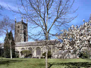
More on Sampford Courtenay below |
| SAMPFORD COURTENAY and the 1549 PRAYER BOOK REBELLION The use of the first English Prayer Book of 1549 on Whit Sunday 1549 marked the beginning of the Prayer Book Rebellion of that year, which started in Sampford Courtenay. On Whit Monday the parishioners forced the Priest to go back to the old Latin Mass, contrary to the commands of the King's Council. This caused trouble with the magistrates and in the ensuing argument, one Wiliam Hellyons was killed on the steps of the Church House. There was then no going back and the men of Sampford Courtenay joined the men of Cornwall and, gathering thousands of supporters in Devon, marched upon Exeter which they besieged for six weeks. The last battle was fought in this village on August 17th 1549 and the rebellion came to an end with trials and executions. Information from village website. |
Stage 17 - Sampford Courtenay to Chulmleigh - 15 miles
| A longish stage but against the 22 mile Dartmoor route on stage 14/15 an easy one. Start and finish are on roads - care needed on the steep B3096 road into Chulmleigh - but mostly the route follows the valley of the River Taw, on the waymarked Tarka Trail. Whilst not right by the river all the time, I particularly enjoyed this valley section. The Taw winds between between gentle hills, rising to 500 feet; the landscape is lightly wooded and pastoral. Bridges are worth a look, notably at Yeo, Bondleigh, Taw Bridge and Chenson. There are some interesting villages and churches. North Tawton, off the trail, was a thriving medieval woollen and market town; St. Peters church has an unusual oak-shingled spire. St. James church, Bondleigh has fine 15th century bench ends. Hilly Chulmleigh is now a quiet place but its position on the former main route from Exeter to Barnstaple meant that it was once a prosperous woollen and market town with many posting houses. It no longer has a market but retains its annual street fair, held since the 13th century. It is a town worth lingering over, its centre a conservation area. Buildings are of local stone or of cob under thatch. Among the best is the Old Court House Inn, where Charles I is reputed to have stayed. St. Mary Magdalene church has a handsome full-width rood screen and wagon roofs with deeply carved bosses. |  |
| Interest item on River Taw |
|
Stage 18 - Chulmleigh to South Molton - 11.5 miles - 16 to North Molton
|
I enjoyed this stage for its interesting churches (and good pubs at Kings Nympton and George Nympton). The River Taw has been left behind and now the going is mostly hilly, passing through some spectacular scenery. Leaving Chulmleigh, there is a lovely minor road walk with extensive views back to North Dartmoor; just stand and gaze! There is a more direct route but I prefer this for the quiet road and the views. The trail continues to Kings Nympton, sold by Henry VII to Sir Lewis Pollard of Bishops Nympton. The village has charming thatched cottages, a pub, the Grove Inn, and a lovely church, crowned by a tall shingled spire and with good roof bosses and a fine rood screen inside. After passing Venn Farm do pause, in anticipation of the next stage, to enjoy the view of superb Exmoor countryside with South Molton nestling below it; pity about the ugly looking works with chimneys! After crossing the River Mole you come to George Nympton where a delightful church has a charm of its own with lovely windows and a rare organ. Lunch there at the excellent Castle Inn. Two miles on you come to new housing estates, the beginning of South Molton. Here you can get lost very easily as the footpath disappears, so be wary!! South Molton grew as a market town round St. Marys church. Once an important woollen centre, in 1357 the town was granted a charter to hold a market and an annual fair. |
|
|
Alternative finish in North Molton in the box below |
| Although the stage ends at South Molton, I chose to continue to North Molton, partly for a quieter overnight stay, partly to equalise the lengths of stages 18 and 19. I was pleased that I did as I really enjoyed the walk mostly between woodland and the River Mole. And even more pleased that I would have the time to linger a little over the next stage which crosses southern Exmoor. |
Stage 19 - South Molton to Dulverton - 19 miles - 16 from North Molton
| A particularly long stage, so I was pleased that I had extended the last stage to North Molton, reducing this to 16 miles and allowing time to enjoy Exmoor. Going is quite strenuous in places, particularly climbing from Twitchen up onto Molland Common. I particularly like this stage, my favourite since leaving Dartmoor, for its two lovely river valleys and the chance to enjoy open Exmoor, crossing Anstey Rhiney Moor. On a clear day views over Exmoor are superb and I felt a great sense of peace and tranquillity. Leaving the open moor you reach the Somerset border at Danes Brook. The map suggests that you can cross the brook to Zeal Farm. I chickened out, feeling that, without a horse, I would need waders, and followed the brook to Slade Lane. Hawkridge church, though much rebuilt, still has its Norman south door and font; I enjoyed my sandwich lunch there. You then head east on a lovely ridge walk, with the River Barle to your left, to Castle Bridge, and then follow the Barle through woodland to Marsh Bridge. Dulverton is an attractively busy town. First recorded in 1084, the middle ages saw continued growth of fairs and markets. No market now but there are good shops, restaurants, pubs and an Exmoor National Park Centre. The old Market House, now the Town Hall, dates from 1760. The parish church - nice lych gate - is 15th century, and the bridge over the Barle dates from medieval times. |  |
| Exmoor National Park |
|
| On Exmoor, I would have liked to detour for the bronze age barrows and longstone on Anstey Common, for the hill forts above the Barle, for Tarr Steps further up the river, and for Ashway, birthplace of YMCA founder Sir George Williams, but time was pressing. Those interested in such things may like to spend an extra night in Dulverton and explore all these. And, if you can find time, do stop to enjoy the sumptuous cream tea served at Marsh Bridge Cottage on the last leg shortly before Dulverton. |
Stage 20 - Dulverton to Wiveliscombe - 13.5 miles
 |
After the rigours of Exmoor and two delightful river valley walks, this 13.5 mile stage can be easier going if you wish, thanks to a choice soon after starting (see below). From Dulverton the trail heads eastwards on the busy B3222 to Hele Bridge over the River Exe - beware of traffic here - and veers round a hill with Bury Castle (a Norman motte and bailey) on the right above you in woodland. Then comes the hamlet of Bury, where there is a fine hump-backed bridge; I enjoyed a coffee break while admiring it. Out of Bury, the trail follows a bridleway, the rather mucky Haddon Lane, as it climbs to Haddon Hill. I enjoyed climbing 1170 foot Hadborough, the high point of Haddon Hill, and relished the views over Wimbleball Lake and the surrounding countryside before the gentle descent of Haddon Hill to Bridge End. From there the route is includes minor roads, tracks and footpaths through beautiful rolling countryside. Theres good food at the traditional Lowtrow Cross Inn. Eventually, you come to Huish Champflower village - by footpath which is not easy to find - with a 15th century church and a house called Washbottle; a watermill ground corn from 1086 to 1914. Then over a hill to the market town of Wiveliscombe, once renowned for wool and for its brewery built in 1807 by William Hancock. St Andrews church is Victorian. |
|
|
Alternative valley route to bridge end - see box below |
| The alternative lowland valley route from Bury to Bridge End is a delight, too. A bridleway follows the River Haddeo as it winds through a steep wooded valley between Storridge and Haddon Woods. After a couple of miles it comes to the weir and dam on Wimbleball Lake, a nice spot for a break. The bridleway continues along the lake, passing through a deer park, and rejoins the route just before Bridge End. |
|
Tavistock to Avebury |
Index to Commentary |
Things to look out for along the trail |
The route from Land's End to Tavistock |
Return to LET Home |
| Oliver's Cornwall | Ramblers Association | Long Distance Walkers Association | Backpackers Club | Contact LET Group |
|
|
|