| Oliver's Cornwall |
|
The Cornish Coast Path |
|
|
|
|
Text and images should align.
To view this page at its best, adjust your zoom to fill screen width
| This page, and the pages linked to it, have been replaced by pages on my new collection of Walking Pages. So far as the coast is concerned, these are divided into two parts. First is a linear description of the Cornish Coast Path with GPS data, from Welcome Mouth, just over the north Devon border, to Cremyll, at the path's termination opposite Plymouth. Second is a series of Round Walks from the Coast Path. Both these projects are complete and have been uploaded. Although this page is now effectively redundant, I have retained it to provide links to a few features remaining on my old coast pages - North Coast - Far West - South Coast |
ON THIS PAGE
|
|
|
|
|
|
LINKS TO THE THREE OLD COAST PATH PAGES
|
|
|
|
CORNWALL REVIEWS INDEX and SITE CONTENTS
|
|
|
|
|
|
|
|
|
|
|
|
|
|
|
|
|
|
|
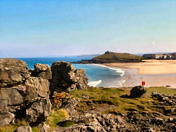
| England's longest official trail is the South West Coast Path, from Minehead on the Bristol Channel to Poole on the English Channel. Total length is said to be 630 miles but it must be more. Of this, the greatest part is in Cornwall where the official calculation, once 260 miles, is now approximately 297 miles. My own calculation, having walked every inch of it with a GPS, is that, if you follow the path faithfully and walk out to all the accessible headlands, and down to all the accessible coves, you will cover 312 GPS miles from Welcombe Mouth just over the North Devon border - no parking at Marsland Mouth on the border - to Cremyll Ferry on Plymouth Sound. Characteristics vary greatly along the way. The highest cliffs are near the North Devon border, rising at High Cliff to 731 feet. Along the north there is generally less vegetation and, while many small streams tumble over cliffs, only one serious river, the Camel, intrudes. Between Newquay and Hayle there are 'towans', vast sand dunes where you may have to walk on the beach. The West Penwith peninsula, that mysterious land beyond St. Ives and Penzance, contains the most difficult walking with many steep ascents and much rock-scrambling. The south coast is more wooded and the rivers have drowned valley estuaries - Helford, Fal, Fowey, Looe and the great Tamar on the Devon boundary. |
 |
| Now go to my Cornish Coast Path page |
|
Online Mapping - Cornwall Council's Mapping Website
|
The recently introduced
'Right to Roam' legislation - long agitated for by the Ramblers Association,
and initially opposed by many landowners - has resulted in vast areas of
land all over England, Scotland, Wales and Cornwall being opened up to
the general public. Essentially these rights are for walkers only
- suits me. I used to find the Countryside Agency's Open Access website
an immense help in my Cornwall moorland walking, not just on Bodmin Moor
but also in West Penwith. Unfortunately the site has been messed
around with. Maximum scale is now much smaller and navigation is
quite awkward. As a result, it is no longer worth, as a walker,
using it in its current CRoW Access form. .
Fortunately, Cornwall Council has an excellent mapping web site, which I find better than the Open Access site ever was. It is easy to use, shows Open Access land, rights of way, path numbers should you wish to report problems, and is zoomable up to large scale. A word of warning on Open Access land.. I soon discovered that this may not be quite as straightforward as that. I have encountered barbed wire fences, locked gates and even one gate on Bodmin Moor, leading to access land, that has a 'no walkers' sign on it. And, in West Penwith, where moorland is lower, I have found impenetrable furze and bramble. So don't expect it always to be easy. |
|
|
OS Explorer maps show Open Access land yellow |
Ordnance
Survey Maps - 1:25000 Landranger Series
 |
My earliest walking
was done with Jane with the Independent Ramblers, based in Ealing.
With them we learned to love the Chilterns and the Cotswolds. But
we soon graduated to our own independent walks, first from walk books,
later of our own devising. The Ordnance Survey 1:25000 series
became our bible. The current 2005 Explorer series still is my bible
(to a degree) particularly as it now shows Open Access land. But,
as with the Bible, you learn not to believe every word. I use OS
maps, GPS and compass on most walks, especially on Bodmin Moor and on the
moors of West Penwith. But I have lost some trust in OS.
Since completing Mark Camp's Copper Trail during winter 2006, I have been walking routes of my own devising on Bodmin Moor and have been horrified to discover just how unreliable the Ordnance Survey can be. A couple of walks in December 2006 proved that. A path shown from Butterstor to Garrow simply does not exist yet OS quite fails to show a well waymarked path from Brown Willy to Garrow (and on to King Arthur's Hall). Below Garrow the OS fails to mark a footbridge over the De Lank River. It also fails to show a footbridge and clapper bridge that cross the river at the southern foot of Garrow Tor. Elsewhere I have found marsh that isn't shown, probably because it is not low-lying. So be advised, take your map, take your compass and expect the unexpected. |
|
|
Don't expect all antiquities to be marked either |
Walking Trail Books - Our Preferred Guides
 |
CIRCULAR WALK GUIDES
Jarrold Pathfinder Cornwall Walks: 28 walks, most include coast, distances 4 to 11 miles. Good large scale Ordnance Survey maps, good descriptions and information. AA 50 Walks in Cornwall: Mostly coast but includes about 10 inland, 3 to 8 miles. Good descriptions and information, sketch maps could be much better, good on severity. Classic Walks in Cornwall: 2 volumes, each of 60 walks, all but 5 include coast, 3 to 6 miles. Good descriptions and information, poor sketch maps, good on severity. Circular Coast Walks Cornwall: by Moor, Dale and Mountain Press. 36 walks, 3 to 10 miles. Good information, routes not too clear, sketch maps. Ramblers Association: 14 volumes, each of 6 or so walks. See their web site Bodmin Moor Walks: Best of Bodmin Moor by Mark Camp; 18 short walks in three volumes. TRAIL GUIDES
|
|
|
| WALKABOUT WEST
Mark Camp offers guided walks generally in Cornwall and especially on Bodmin
Moor. Mark is one of the experts on Bodmin Moor: its
history, its antiquities and its industries - tin and copper mining, granite
quarrying aned china clay production. Mark has also published a number
of books about Bodmin Moor - four books of Short Walks, a new (March 2009)
Introductory Guide and a guide to the trail that he devised, the 60 mile
Copper Trail around the moor.
Links: Mark's WalkaboutWest ENCOUNTER CORNWALL This was new to me when I spotted it in April 2009. I had a good browse of their web site and think it well worth bringing to your attention. Encounter Cornwall organises walking tours - self-guided and supported - and has a recommended accommodation list. Tours, varying from 2 to 10 days, include the Coast Path, The Copper Trail, three Coast-to-Coast trails (Saints Way, St. Michaels Way and Smugglers Way) and some one centre breaks. Their programme also covers supported cycle tours with bike hire and guided kayaking trips on the Fowey River. They now only do Kayak and Canoe tours. Their web site Encounter Cornwall |
|
| I am sure there are many others but I don't know them |
|
|
|
|
|
|
|
|
|
|
|
|
|
|
|
|
|
|
|
|